Mussig
show This article may be expanded with text translated from the corresponding article in French. (December 2008) Click [show] for important translation instructions. |
Mussig
Müssig | |
|---|---|
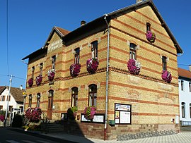 The town hall in Mussig | |
 Coat of arms | |
show Location of Mussig | |
 Mussig | |
| Coordinates: 48°13′46″N 7°31′15″E / 48.2294°N 7.5208°ECoordinates: 48°13′46″N 7°31′15″E / 48.2294°N 7.5208°E | |
| Country | France |
| Region | Grand Est |
| Department | Bas-Rhin |
| Arrondissement | Sélestat-Erstein |
| Canton | Sélestat |
| Intercommunality | Sélestat |
| Government | |
| • Mayor (2014–2020) | Jean-Claude Hilbert |
| Area 1 | 11.73 km2 (4.53 sq mi) |
| Population (Jan. 2018)[1] | 1,168 |
| • Density | 100/km2 (260/sq mi) |
| Time zone | UTC+01:00 (CET) |
| • Summer (DST) | UTC+02:00 (CEST) |
| INSEE/Postal code | 67310 /67600 |
| Elevation | 167–174 m (548–571 ft) |
| 1 French Land Register data, which excludes lakes, ponds, glaciers > 1 km2 (0.386 sq mi or 247 acres) and river estuaries. | |


Mussig is a commune in the Bas-Rhin department in Alsace in north-eastern France. Successive known names carried by the village were: Moussich, Mosich (1370) and Musich (1453) before becoming Musselburgh. The etymological origin is probably to be found in the existence of wetlands and swamps are conducive to the formation of foam. Until the 19th century[clarification needed] was practiced widely growing flax and hemp, woven at home or delivered to the weavers in the valley of Sainte-Marie-aux-Mines, this is still in the early twentieth century.
See also[]
References[]
- ^ "Populations légales 2018". INSEE. 28 December 2020.
| Wikimedia Commons has media related to Mussig. |
This Bas-Rhin geographical article is a stub. You can help Wikipedia by . |
Categories:
- Communes of Bas-Rhin
- Bas-Rhin geography stubs