La Vancelle
show This article may be expanded with text translated from the corresponding article in French. (December 2008) Click [show] for important translation instructions. |
La Vancelle | |
|---|---|
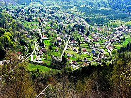 A general view of La Vancelle | |
 Coat of arms | |
show Location of La Vancelle | |
 La Vancelle | |
| Coordinates: 48°17′13″N 7°18′17″E / 48.2869°N 7.3047°ECoordinates: 48°17′13″N 7°18′17″E / 48.2869°N 7.3047°E | |
| Country | France |
| Region | Grand Est |
| Department | Bas-Rhin |
| Arrondissement | Sélestat-Erstein |
| Canton | Sélestat |
| Intercommunality | Sélestat |
| Government | |
| • Mayor (2020–2026) | Michèle Claver[1] |
| Area 1 | 7.88 km2 (3.04 sq mi) |
| Population (Jan. 2018)[2] | 402 |
| • Density | 51/km2 (130/sq mi) |
| Time zone | UTC+01:00 (CET) |
| • Summer (DST) | UTC+02:00 (CEST) |
| INSEE/Postal code | 67505 /67730 |
| Elevation | 217–810 m (712–2,657 ft) (avg. 400 m or 1,300 ft) |
| 1 French Land Register data, which excludes lakes, ponds, glaciers > 1 km2 (0.386 sq mi or 247 acres) and river estuaries. | |


La Vancelle (German: Wanzel) is a commune in the Bas-Rhin department in Alsace in north-eastern France.
See also[]
References[]
- ^ "Répertoire national des élus: les maires". data.gouv.fr, Plateforme ouverte des données publiques françaises (in French). 2 December 2020.
- ^ "Populations légales 2018". INSEE. 28 December 2020.
| Wikimedia Commons has media related to La Vancelle. |
This Bas-Rhin geographical article is a stub. You can help Wikipedia by . |
Categories:
- Communes of Bas-Rhin
- Bas-Rhin geography stubs