Kurtzenhouse
show This article may be expanded with text translated from the corresponding article in French. (December 2008) Click [show] for important translation instructions. |
Kurtzenhouse
Kurzehüse | |
|---|---|
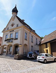 The town hall in Kurtzenhouse | |
 Coat of arms | |
show Location of Kurtzenhouse | |
 Kurtzenhouse | |
| Coordinates: 48°44′27″N 7°48′28″E / 48.7408°N 7.8078°ECoordinates: 48°44′27″N 7°48′28″E / 48.7408°N 7.8078°E | |
| Country | France |
| Region | Grand Est |
| Department | Bas-Rhin |
| Arrondissement | Haguenau-Wissembourg |
| Canton | Brumath |
| Government | |
| • Mayor (2020–2026) | Marc Moser[1] |
| Area 1 | 3.58 km2 (1.38 sq mi) |
| Population (Jan. 2018)[2] | 1,052 |
| • Density | 290/km2 (760/sq mi) |
| Time zone | UTC+01:00 (CET) |
| • Summer (DST) | UTC+02:00 (CEST) |
| INSEE/Postal code | 67252 /67240 |
| Elevation | 126–179 m (413–587 ft) |
| 1 French Land Register data, which excludes lakes, ponds, glaciers > 1 km2 (0.386 sq mi or 247 acres) and river estuaries. | |


Kurtzenhouse (German: Kurzenhausen) is a commune in the Bas-Rhin department in Grand Est in north-eastern France.
Until January 1955 the commune was known by its German language name of "Kurtzenhausen".
Geography[]
The village is positioned about ten kilometres (six miles) south of Haguenau: the surrounding countryside is largely taken up with agriculture. Through the south-eastern side of the commune runs the departmental road RD 37, and beside that the rather indirect railway line that connects Haguenau with Strasbourg to the south.
See also[]
References[]
- ^ "Répertoire national des élus: les maires". data.gouv.fr, Plateforme ouverte des données publiques françaises (in French). 2 December 2020. Retrieved 7 December 2020.
- ^ "Populations légales 2018". INSEE. 28 December 2020.
| Wikimedia Commons has media related to Kurtzenhouse. |
This Bas-Rhin geographical article is a stub. You can help Wikipedia by . |
Categories:
- Communes of Bas-Rhin
- Bas-Rhin geography stubs