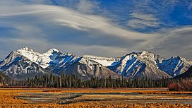
Fairholme Range
| Fairholme Range | |
|---|---|
 | |
| Highest point | |
| Peak | Mount Girouard |
| Elevation | 2,995 m (9,826 ft)[1] |
| Coordinates | 51°14′10″N 115°24′11″W / 51.23611°N 115.40306°W[2] |
| Geography | |
 | |
| Country | Canada |
| Province | Alberta |
| Range coordinates | 51°08′59″N 115°19′36″W / 51.14972°N 115.32667°WCoordinates: 51°08′59″N 115°19′36″W / 51.14972°N 115.32667°W[3] |
| Parent range | Front Ranges |
| Topo map | NTS 82O3 Canmore |

The Fairholme Range is a mountain range east of the Bow River valley in the Canadian Rockies. The range is bounded on the west side by the Trans-Canada Highway as it passes through the towns of Exshaw and Canmore, while the northern section of the range extends into Banff National Park to the southern shores of Lake Minnewanka.[4] John Palliser named the range in 1859 after his sister Grace Fairholme, who had married William Fairholme.[5]
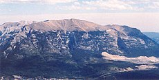
Peaks of this range include:
| Mountain/Peak | metres | feet |
|---|---|---|
| Mount Girouard | 2,995 | 9,827 |
| Mount Inglismaldie | 2,964 | 9,725 |
| Mount Peechee | 2,935 | 9,630 |
| Mount Charles Stewart | 2,809 | 9,216 |
| Grotto Mountain | 2,706 | 8,878 |
| Mount Lady Macdonald | 2,606 | 8,550 |
| Princess Margaret Mountain | 2,515 | 8,252 |
| Anû Kathâ Îpa | 2,514 | 8,250 |
Anû Kathâ Îpa, the last entry in the table above, is the official new name of a mountain that previously held a racist and offensive term. [6]
In the spring and summer of 2003, Parks Canada performed a prescribed burn in selected areas of the range in order to reduce fire hazard, manage pine beetle population and increase sheep habitat. In total, 5300 hectares of land were affected.[7]
Further reading[]
- Patton, Brian; Robinson, Bart (31 March 2011). Canadian Rockies Trail Guide. pp. 16, 32. ISBN 9780978237509.
- Patton, Brian (July 2007). Parkways of the Canadian Rockies: A Touring Guide to Banff, Jasper, Kootenay. pp. 13–14, 41. ISBN 9780978237523.
References[]
- ^ "Mount Girouard". PeakFinder.com. Retrieved 2019-08-02.
- ^ "Mount Girouard". Geographical Names Data Base. Natural Resources Canada. Retrieved 2019-08-02.
- ^ "Fairholme Range". Geographical Names Data Base. Natural Resources Canada. Retrieved 2019-08-02.
- ^ Ommanney, Simon (2002). Williams, Jr., Richard; Ferrigno, Jane (eds.). "Glaciers of the Canadian Rockies" (PDF). U.S. Geological Survey Professional Paper 1386: Satellite Image Atlas of the Glaciers of the World -- North America. Washington, D.C.: USGS: 224. Retrieved 2019-08-02.
- ^ "Fairholme Range". PeakFinder.com. Retrieved 2004-06-15.
- ^ "Beyond Local: Stoney Nakoda restores traditional name to peak with racist nickname". StAlbertToday.ca. Retrieved 2022-01-31.
- ^ "2003 Prescribed burn in the Fairholme Range". Parks Canada. Archived from the original on 2011-07-06. Retrieved 2005-10-16.
- Two-thousanders of Alberta
- Ranges of the Canadian Rockies