Rainbow Range (Rocky Mountains)
| Rainbow Range | |
|---|---|
 | |
| Highest point | |
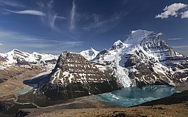
| Peak | Mount Robson |
| Elevation | 3,954 m (12,972 ft)[1] |
| Coordinates | 53°06′38″N 119°09′23″W / 53.11056°N 119.15639°W[2] |
| Dimensions | |
| Area | 497 km2 (192 sq mi)[3] |
| Geography | |
 | |
| Country | Canada |
| Provinces | British Columbia and Alberta |
| Range coordinates | 53°03′N 119°03′W / 53.050°N 119.050°WCoordinates: 53°03′N 119°03′W / 53.050°N 119.050°W[4] |
| Parent range | Canadian Rockies |


The Rainbow Range is a small subrange of the Park Ranges subdivisions of the Northern Continental Ranges of the Rocky Mountains on the border between Alberta and British Columbia in Mount Robson Provincial Park.
Its highest summit, and the highest in the Canadian Rockies, is Mount Robson 3,954 m (12,972 ft), followed by nearby Resplendent Mountain 3425 m (11241 ft) and Mount Kain 2863 m (9393 ft).

See also[]
References[]
- ^ "Mount Robson Provincial Park". BC Parks. Government of British Columbia. Retrieved 2019-08-19.
- ^ "Mount Robson". Geographical Names Data Base. Natural Resources Canada. Retrieved 2019-08-19.
- ^ "Rainbow Range". Peakbagger.com. Retrieved 2012-05-19.
- ^ "Rainbow Range". BC Geographical Names. Retrieved 2012-05-19.
External links[]
- Bivouac - Rainbow Range
This article about a location in the Interior of British Columbia, Canada is a stub. You can help Wikipedia by . |
Categories:
- Ranges of the Canadian Rockies
- Mountain ranges of British Columbia
- Robson Valley
- British Columbia Interior geography stubs