Faiyum Oasis
This article needs additional citations for verification. (February 2019) |
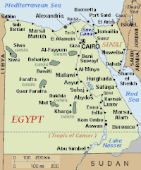

The Faiyum Oasis (Arabic: واحة الفيوم Waḥet El Fayyum) is a depression or basin in the desert immediately to the west of the Nile south of Cairo in Egypt. The extent of the basin area is estimated at between 1,270 km2 (490 mi2) and 1700 km2 (656 mi2). The basin floor comprises fields watered by a channel of the Nile, the Bahr Yussef, as it drains into a desert hollow to the west of the Nile Valley. The Bahr Yussef veers west through a narrow neck of land north of , between the archaeological sites of El Lahun and near Hawara; it then branches out, providing rich agricultural land in the Faiyum basin, draining into the large saltwater Lake Moeris (Birket Qarun).[1] The lake was freshwater in prehistory but is today a saltwater lake.[1] It is a source for tilapia and other fish for the local area.
Differing from typical oases, whose fertility depends on water obtained from springs, the cultivated land in the Faiyum is formed of Nile mud brought down by the Bahr Yussef, 24 km (15 miles) in length.[2] Between the beginning of Bahr Yussef at El Lahun to its end at the city of Faiyum, several canals branch off to irrigate the Faiyum Governorate. The drainage water flows into Lake Moeris.
History[]

When the Mediterranean Sea was a hot dry hollow near the end of the Messinian Salinity Crisis in the late Miocene, Faiyum was a dry hollow, and the Nile flowed past it at the bottom of a canyon (which was 8,000 feet (2,400 m) deep or more where Cairo is today).[3][4] After the Mediterranean reflooded at the end of the Miocene, the Nile canyon became an arm of the sea reaching inland further than Aswan. Over geological time that sea arm gradually filled with silt and became the Nile valley.[citation needed]
Eventually the Nile valley bed silted up high enough to let the Nile periodically overflow into the Faiyum Hollow and make a lake in it. The lake is first recorded from about 3000 BC, around the time of Menes (Narmer). However, for the most part it would only be filled with high flood waters. The lake was bordered by neolithic settlements, and the town of Crocodilopolis grew up on the south where the higher ground created a ridge.[citation needed]
In 2300 BC, the waterway from the Nile to the natural lake was widened and deepened to make a canal which is now known as the Bahr Yussef. This canal fed into the lake. This was meant to serve three purposes: control the flooding of the Nile, regulate the water level of the Nile during dry seasons, and serve the surrounding area with irrigation. There is evidence of ancient Egyptian pharaohs of the twelfth dynasty using the natural lake of Faiyum as a reservoir to store surpluses of water for use during the dry periods. The immense waterworks undertaken by the ancient Egyptian pharaohs of the twelfth dynasty to transform the lake into a huge water reservoir gave the impression that the lake itself was an artificial excavation, as reported by classic geographers and travellers.[5] The lake was eventually abandoned due to the nearest branch of the Nile dwindling in size from 230 BC.

Faiyum was known to the ancient Egyptians as the twenty-first nome of Upper Egypt, Atef-Pehu ("Northern Sycamore"). In ancient Egyptian times, its capital was Sh-d-y-t (usually written "Shedyt"),[6] called by the Greeks Crocodilopolis, and refounded by Ptolemy II as Arsinoe.[citation needed]
This region has the earliest evidence for farming in Egypt, and was a center of royal pyramid and tomb-building in the Twelfth dynasty of the Middle Kingdom, and again during the rule of the Ptolemaic dynasty. Faiyum became one of the breadbaskets of the Roman world.
For the first three centuries AD, the people of Faiyum and elsewhere in Roman Egypt not only embalmed their dead but also placed a portrait of the deceased over the face of the mummy wrappings, shroud or case. The Egyptians continued their practice of burying their dead, despite the Roman preference for cremation. Preserved by the dry desert environment, these Faiyum portraits make up the richest body of portraiture to have survived from antiquity. They provide us with a window into a remarkable society of peoples of mixed origins—Egyptians, Greeks, Romans, Syrians, Libyans and others—that flourished 2,000 years ago in Faiyum. The Faiyum portraits were painted on wood in a pigmented wax technique called encaustic.[7]
In the late 1st millennium AD, the arable area shrank, and settlements around the edge of the basin were abandoned. These sites include some of the best-preserved from the late Roman Empire, notably Karanis, and from the Byzantine and early Arab Periods, though recent redevelopment has greatly reduced the archaeological features. In addition to the mummy portraits, the villages of the Faiyum have also proven to be an important source of papyrus fragments containing literature and documents in Latin, Greek, and different Egyptian scripts.

"Colonial-type" village names (villages named after towns elsewhere in Egypt and places outside Egypt) show that much land was brought into cultivation in the Faiyum in the Greek and Roman periods.[8]
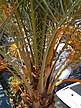
According to the Encyclopædia Britannica Eleventh Edition, in 1910 over 1,000 km2 (400 mile2) of the Faiyum Oasis was cultivated, the chief crops being cereals and cotton. The completion of the Aswan Low Dam ensured a fuller supply of water, which enabled 20,000 acres (80 km2) of land, previously unirrigated and untaxed, to be brought under cultivation in the three years 1903-1905. Three crops were obtained in twenty months. The province was noted for its figs and grapes of exceptional quality. Olives were also cultivated. Rose trees were very numerous, and most of the attar of roses of Egypt was manufactured in the province. Faiyum also possessed an excellent breed of sheep.[2]
Archaeology[]
There are, especially in the neighborhood of the lake, many ruins of ancient villages and cities. Mounds north of the city of Faiyum mark the site of Crocodilopolis/Arsinoe. There are extensive archaeological remains across the region which extend from the prehistoric period through to modern times, e.g. the Monastery of the Archangel Gabriel at Naqlun.
The cult of Sobek[]
In antiquity, the Fajyum was a center of the cult of the crocodile god Sobek. In many settlements, temples were dedicated to local manifestations of the god and associated divinities.[9] The priests of Sobek were key players in the social and economic life, for example by organizing religious festivals or by purchasing goods from local producers. Even in Roman times, priests of these temples therefore enjoyed various privileges. The development of temples dedicated to the Sobek cult can be studied particularly well in Bakchias, Narmouthis, Soknopaiou Nesos, Tebtunis, and Theadelphia, since many written sources (papyri, ostraka, inscriptions) on the daily life of the priests are available from these places.[10]
Egyptian temples have been operating at the edges of the Fayyum at least up until the early third century, in some cases still in the fourth century. The institutionalized Sobek cults thus existed alongside early Christian communities, which settled in the region from the third century onwards and built their first churches in the Fayyum settlements by the fourth century.[11]
Birket Qarun lake[]
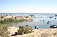
Birket Qarun (Arabic for Lake of Qarun), is located in the Faiyum Oasis and has an abundant population of fish, notably bulti, of which considerable quantities are sent to Cairo.[2] In ancient times this lake was much larger, and the ancient Greeks and Romans called it Lake Moeris.
Cities and towns[]
The largest city is Faiyum, which is also the capital of the Faiyum Governorate. Other towns include Sinnuris and Tamiya to the north of Faiyum, and Sanhur and Ibsheway on the road to the lake.
See also[]
- Bahr Yussef
- Faiyum
- Faiyum Governorate
- Farafra
- Fayum mummy portraits
- Lake Moeris
- Monastery of the Archangel Gabriel at Naqlun
- Phiomia (an extinct relative of the elephant, named after Faiyum)
- Roman Egypt
- The Alchemist (novel), in which it is a primary setting
Notes[]
- ^ Jump up to: a b "Lake Moeris". www.brown.edu. Retrieved 2018-08-14.
- ^ Jump up to: a b c One or more of the preceding sentences incorporates text from a publication now in the public domain: Chisholm, Hugh, ed. (1911). "Fayum". Encyclopædia Britannica. 10 (11th ed.). Cambridge University Press. p. 219.
- ^ Warren, John (2006). Evaporites: Sediments, Resources and Hydrocarbons. Berlin: Springer. p. 352. ISBN 3-540-26011-0.
- ^ El Mahmoudi, A.; Gabr, A. (2008). "Geophysical surveys to investigate the relation between the Quaternary Nile channels and the Messinian Nile canyon at East Nile Delta, Egypt". Arabian Journal of Geosciences. 2 (1): 53–67. doi:10.1007/s12517-008-0018-9. ISSN 1866-7511. S2CID 128432827.
- ^ Catholic Encyclopedia: Egypt
- ^ Hieroglyphic writing did not have vowels, so spellings vary as to use of vowels for names in Egyptian culture. Hieroglyphic pronunciation was indicated by determinatives which showed what sort of meaning the word had.
- ^ "History of Encaustic Art". Archived from the original on 2012-12-23.
- ^ For late-period Ancient Egyptian names of the Faiyum oasis and places within it, see http://fayum.arts.kuleuven.be/general/name.html Archived 2007-08-15 at archive.today
- ^ Kockelmann, Holger (2017). Der Herr der Seen, Sümpfe und Flußläufe. Untersuchungen zum Gott Sobek und den ägyptischen Krokodilgötter-Kulten von den Anfängen bis zur Römerzeit. Wiesbaden: Harrassowitz. pp. 19–63, 375–421. ISBN 978-3-447-10810-2.
- ^ Sippel, Benjamin (2020). Gottesdiener und Kamelzüchter: Das Alltags- und Sozialleben der Sobek-Priester im kaiserzeitlichen Fayum. Wiesbaden: Harrassowitz. ISBN 978-3-447-11485-1.
- ^ Choat, Malcolm (2012). Riggs, Christina (ed.). Christianity. The Oxford Handbook of Roman Egypt. Oxford, New York: Oxford Univ. Press. pp. 474–489. ISBN 978-0-19-957145-1.
References[]
Coordinates: 29°27′13″N 30°34′51″E / 29.45361°N 30.58083°E

| hide Egyptian oases | ||
|---|---|---|
 | ||
| ||
| Authority control |
|---|
- Faiyum Governorate
- Geography of ancient Egypt
- Oases of Egypt