Faleolo International Airport
This article uses bare URLs, which may be threatened by link rot. (September 2021) |
Faleolo International Airport | |||||||||||
|---|---|---|---|---|---|---|---|---|---|---|---|
 | |||||||||||
| Summary | |||||||||||
| Airport type | Public | ||||||||||
| Serves | Apia, Upolu Island, Samoa | ||||||||||
| Elevation AMSL | 58 ft / 18 m | ||||||||||
| Coordinates | 13°49′47″S 172°00′30″W / 13.82972°S 172.00833°W | ||||||||||
| Maps | |||||||||||
 Apia in Samoa | |||||||||||
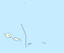 APW /NSFA Location of airport in Samoa | |||||||||||
| Runways | |||||||||||
| |||||||||||

Faleolo International Airport (IATA: APW, ICAO: NSFA) is an airport located 40 kilometres (25 mi) west of Apia, the capital of Samoa. Until 1984, Faleolo could not accommodate jets larger than a Boeing 737. Services to the United States, Australia, or New Zealand, could only land at Pago Pago International Airport in American Samoa. Since the airport's expansion most international traffic now uses Faleolo.
Until 31 December 2019 small turboprop aircraft used to connect American Samoa and Samoa from Fagali'i Airport in the eastern suburbs of Apia. With the closure of Fagali’i Airport, all aircraft now use Faleolo.
History[]
Faleolo Airfield[]
The site and location of the current airport was originally known as Faleolo Airfield.[2] It was constructed by the United States Navy SeaBees of 1st Construction Battalion after war broke out in the Pacific in 1942. It became an auxiliary field of U.S. Naval Station Tutuila in the Samoa Defense Group Area[3] during the Pacific War. Faleolo Airfield was completed by the Seabees in July 1942[4] and U.S. Marine Fighting Squadron VMF-111 was moved from Tafuna Airfield to Faleolo Airfield[4] after the aircraft runway was completed[2] to protect the islands of Upolu and Savai'i from an anticipated Japanese invasion. The original runway was 4,000 feet (1,219 m) x 200 feet (61 m) and was extended to 6,000 feet (1,829 m) x 350 feet (107 m) in March 1943 to accommodate a taxiway and space for basing of up to 57 fighter aircraft. Airfield support buildings and two hangars were also constructed and completed in March 1943. Until 1984, Faleolo could not accommodate jets larger than a Boeing 737. Services to the United States, Australia, or New Zealand, could only land at Pago Pago International Airport in American Samoa. Since the airport's expansion, the Airport now caters for most international traffic arriving from New Zealand, Australia, Fiji, Tonga, Hawaii and USA.
Facilities[]
The airport is at an elevation of 58 feet (18 m) above mean sea level. It has one runway designated 08/26 with an asphalt surface measuring 3,000 by 45 metres (9,843 ft × 148 ft).[5] The Pavement Classification Number for the runway is 058FBXT.[5]
Faleolo Tower has some jurisdiction over the airspace of American Samoa and Tonga as well as its own airspace. It is assisted by the tower at Nadi, Fiji and the whole area is under Oceanic Control from Auckland, New Zealand.[6]
Airlines and destinations[]
| Airlines | Destinations |
|---|---|
| Air New Zealand | Auckland |
| Fiji Airways | Honolulu,[7] Nadi |
| Fiji Link | Suva[8] |
| Samoa Airways | Auckland, Brisbane,[9] Pago Pago, Savai'i,[10] Sydney[11] |
| Talofa Airways | Nuku'alofa, Pago Pago |
| Virgin Australia | Brisbane, Sydney[12] |
Accidents and incidents[]
- On 13 January 1970, Polynesian Airlines Flight 208B, operated by Douglas C-47B 5W-FAC crashed into the sea shortly after take-off on an international non-scheduled passenger flight to Pago Pago International Airport, American Samoa. All 32 people on board were killed.[13][14]
- In 2000, Air New Zealand flight NZ60 nearly overshot the runway due to a faulty instrument landing system, which had been accidentally damaged by a digger. The pilots took a number of measures to successfully prevent an accident, which were incorporated into a training video. Key points from the video that averted disaster included the pilots' unease about the ILS glideslope capture, the conflict between the aircraft's altitude and the functioning Distance Measuring Equipment, and their familiarity with the approach into Faleolo which caused them to realise they were not where they were supposed to be, had the ILS been functioning correctly. For these reasons they initiated a go around, and used the VOR/DME equipment for the second and successful approach.[15]
References[]
- ^ Airport information for APW at Great Circle Mapper. Source: DAFIF (effective October 2006).
- ^ Jump up to: a b "Building the Navy's Bases in World War II". Department of the Navy Bureau of Yards and Docks, pg 213-214. Retrieved 18 February 2011.
- ^ "The U.S. Naval History of the Samoan Defense Group" (PDF). Lt. Commander John Buake, USNA. Archived from the original (PDF) on 25 July 2011. Retrieved 23 February 2011.
- ^ Jump up to: a b "History of U.S. Marine Corps Operations in World War II". Hough, Ludwig, Shaw - Chapter 3: The Southern Lifeline, pg 90. Retrieved 18 February 2011.
- ^ Jump up to: a b Airport information for NSFA from DAFIF (effective October 2006)
- ^ "Our work in the South Pacific". Airways NZ. Retrieved 24 August 2021.
- ^ "New Samoa-Honolulu flights planned". Pacific Business News. 2009-08-03. Retrieved 2009-08-03.
- ^ http://airlineroute.net/2014/01/20/fj-suvapw-jun14/
- ^ "Samoa Airways launches Brisbane-Apia flights". Retrieved 3 September 2018.
- ^ Liu, Jim. "Samoa Airways resumes Apia – Savai'i from late-August 2020". Routesonline. Retrieved 21 August 2020.
- ^ "Samoa Airways confirms plan to launch services from 14-Nov-2017". CAPA. 25 August 2017. Retrieved 26 August 2017.
- ^ http://australianaviation.com.au/2017/09/virgin-australia-launches-flights-to-samoa/
- ^ "5W-FAC Accident description". Aviation Safety Network. Retrieved 11 October 2010.
- ^ "All 30 Aboard DC‐3 Die In Air Crash in Samoa". New York Times. 14 January 1970. Retrieved 5 August 2021.
- ^ "NZ60 Erronious (sic) ILS Incident, Apia". YouTube. 2006-12-22. Retrieved 2009-09-30.
External links[]
| hide | ||
|---|---|---|
Traditional center: Leulumoega | ||
| Villages |  | |
| Transport | ||
| Environment | ||
| Electoral constituencies: Faipule Districts |
| |
- Airports in Samoa
- Apia
- A'ana
- Tutuila