Fan Island
| Fan Island | |
|---|---|
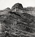
 Southeast aspect, from Colorado River | |
| Highest point | |
| Elevation | 5,092 ft (1,552 m)[1] |
| Prominence | 452 ft (138 m)[1] |
| Parent peak | Powell Plateau (7,661 ft)[2] |
| Isolation | 2.33 mi (3.75 km)[2] |
| Coordinates | 36°15′27″N 112°21′52″W / 36.2575440°N 112.3643134°WCoordinates: 36°15′27″N 112°21′52″W / 36.2575440°N 112.3643134°W[3] |
| Geography | |
 Fan Island Location in Arizona | |
| Location | Grand Canyon National Park Coconino County, Arizona, US |
| Parent range | Kaibab Plateau[1] Colorado Plateau |
| Topo map | USGS King Arthur Castle |
| Geology | |
| Type of rock | Redwall Limestone Tonto Group |
| Climbing | |
| First ascent | Jim Ohlman, Jim Kirschvink[4] |
| Easiest route | class 5.4 climbing[2] |


Fan Island is a 5,092-foot-elevation (1,552 meter) summit located in the Grand Canyon, in Coconino County of northern Arizona, US.[3] It is situated two miles south of Dutton Point, 2.5 miles west-northwest of Dox Castle, and 1.6 miles south-southwest of Masonic Temple. Topographic relief is significant as it rises 2,900 feet (884 meters) above the Colorado River in one mile (0.6 km). Fan Island was so named because the flat top resembles an unfolded hand fan.[5] According to the Köppen climate classification system, Fan Island is located in a cold semi-arid climate zone, with precipitation runoff draining south to the Colorado River via Hakatai Canyon from the west aspect, and Burro Canyon from the east aspect.[6] This butte is an erosional remnant composed of Redwall Limestone overlaying the Tonto Group.[7]
Gallery[]

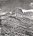
Southeast aspect, 1901
Fan Island in 1901
Fan Island, Burro Canyon

Fan Island (left), with Dutton Point looming behind it. Masonic Temple to right.
Fan Island centered in the distance


See also[]
References[]
- ^ a b c "Fan Island, Arizona". Peakbagger.com. Retrieved 2021-02-25.
- ^ a b c "Fan Island – 5,092' AZ". Lists of John. Retrieved 2021-02-25.
- ^ a b "Fan Island". Geographic Names Information System. United States Geological Survey. Retrieved 2021-02-25.
- ^ Todd R. Berger, Reflections of Grand Canyon Historians: Ideas, Arguments and First-Person Accounts, 2nd edition, 2008, Grand Canyon Association Publisher, ISBN 978-1934656006, p. 198.
- ^ Gregory McNamee, Grand Canyon Place Names, 1997, Mountaineers Publisher, ISBN 978-0898865332, p. 53.
- ^ Peel, M. C.; Finlayson, B. L.; McMahon, T. A. (October 11, 2007). "Updated world map of the Köppen−Geiger climate classification" (PDF). Hydrology and Earth System Sciences. 11 (5): 1633–1644. Bibcode:2007HESS...11.1633P. doi:10.5194/hess-11-1633-2007. Archived (PDF) from the original on February 14, 2021.
- ^ Ralph Lee Hopkins, Hiking the Southwest's Geology: Four Corners Region, 2002, The Mountaineers Books, ISBN 0898868564, p. 91.
External links[]
| Wikimedia Commons has media related to Fan Island. |
- Weather forecast: National Weather Service
- Fan Island photo by Harvey Butchart
- Fan Island (lower right) seen from Dutton Point: photo
- Grand Canyon
- Landforms of Coconino County, Arizona
- Colorado Plateau
- Grand Canyon National Park
- Buttes of Arizona
- North American 1000 m summits
- Grand Canyon, North Rim
- Grand Canyon, North Rim (west)