Farnborough, London
| Farnborough | |
|---|---|
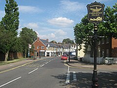 Farnborough High Street with its village sign | |
 Farnborough Location within Greater London | |
| Population | 14,632 (2011 Census. Farnborough and Crofton Ward)[1] |
| OS grid reference | TQ445645 |
| • Charing Cross | 13.4 mi (21.6 km) NW |
| London borough | |
| Ceremonial county | Greater London |
| Region | |
| Country | England |
| Sovereign state | United Kingdom |
| Post town | ORPINGTON |
| Postcode district | BR6 |
| Dialling code | 01689 |
| Police | Metropolitan |
| Fire | London |
| Ambulance | London |
| UK Parliament | |
| London Assembly | |

Farnborough is a village in south-east London, England, located in the historic county of Kent. Situated south of Locksbottom, west of Green Street Green, north of Downe and Hazelwood, and east of Keston, it is centred 13.4 miles (21.6 km) southeast of Charing Cross.
Suburban development following the Second World War resulted in the area becoming contiguous with the conurbation of London. The area has formed part of the London Borough of Bromley local authority district since the formation of the ceremonial county of Greater London for administrative purposes in 1965.
History[]

The village name derives from Fearnbiorginga, meaning a village among the ferns on the hill.[2] Old records date from 862 when Ethelbert, King of Wessex, gave away 950 acres at Farnborough. The village was not included in the Domesday Book of 1086, but the manor existed in the Middle Ages and was held in the 13th century by Simon de Montfort.[3][2]
The village evolved on the main road from London to Hastings which originally ran via Church Road and Old Hill (to the south of the village). The George pub existed in the 16th century and was used as a coaching inn. Coaches and horses were accommodated later.[3] In 1639 a severe storm destroyed St Giles' Church –it was later rebuilt.[2]
Farnborough formed a civil parish in the Ruxley hundred of Kent. In 1840 the parish was included in the Metropolitan Police District. It was part of the Bromley rural sanitary district and went on to form part of the Bromley Rural District from 1894 to 1934. The parish was abolished in 1934 as part of a county review order, following the Local Government Act 1929, and its area was split between the Municipal Borough of Bromley (3 acres) and Orpington Urban District (1,426 acres). The entire area has formed part of the London Borough of Bromley in Greater London since 1965.[4] The population of the parish was as follows:
| Year | 1801 | 1811 | 1821 | 1831 | 1841 | 1851 | 1861 | 1871 | 1881 | 1891 | 1901 | 1911 | 1921 | 1931 |
|---|---|---|---|---|---|---|---|---|---|---|---|---|---|---|
| Population[5] | 314 | 452 | 553 | 638 | 680 | 920 | 955 | 1,086 | 1,451 | 1,627 | 2,262 | 3,210 | 3,322 | 4,373 |
Suburban development occurred in the post-Second World War years, resulting in the former village becoming contiguous with the London conurbation, however Green Belt legislation prevented any further development southwards.[2]
Transport[]
Rail[]
The nearest National Rail station to Farnborough is Orpington, located 1.7 miles away.
Buses[]
Farnborough is served by London Buses routes 358 & R4. These connect it with areas including Beckenham, Bromley, Crystal Palace, Orpington & Penge.
Notable residents[]
- Steve Bennett (b. 1961) - football referee, born in Farnborough[6]
- Urania Boswell aka 'Gypsy Lee' (d. 1933) - local woman dubbed the Queen of the Kent gypsies[2]
- Chris Cowdrey (b. 1957) - cricketer, born in Farnborough[2]
- Nigel Farage (b. 1964) - politician, born in Farnborough[7]
- James Hanratty (b. 1936) - murderer[8]
- Ben Wallace (b. 1970) - politician, born in Farnborough[9]
Gallery[]

Welcome sign

The centre of Farnborough, looking east
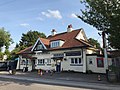
The Woodman pub
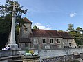
St Giles Church, parts of which date to the 12th century, though heavily modified in the 19th century, with the war memorial to the left[10]

A view to the south from near St Giles the Abbot church

Farnborough Village Hall


References[]
- ^ "Bromley Ward population 2011". Neighbourhood Statistics. Office for National Statistics. Retrieved 10 October 2016.
- ^ Jump up to: a b c d e f Willey, Russ (2006). The London Gazetteer. Chambers Harrap Publishers Ltd. pp. 172–3.
- ^ Jump up to: a b "Farnborough Village Society". Farnboroughvillage.info. Archived from the original on 5 July 2007. Retrieved 26 July 2012.
- ^ Great Britain Historical GIS / University of Portsmouth, Farnborough (historic map). Retrieved 2008-03-31.
- ^ Great Britain Historical GIS / University of Portsmouth, Farnborough population. Retrieved 2008-03-31.
- ^ "Birthdate and Biographical detail". the Football League official website. Archived from the original on 8 June 2008. Retrieved 25 March 2008.
- ^ "Biography of Nigel Farage at the European Parliament". European Parliament. Retrieved 12 July 2019.
- ^ GRO Register of Births DEC 1936 2a 1038 BROMLEY - James Hanratty, mmn = Wilson
- ^ Thomson, Alice; Sylvester, Rachel (9 June 2018). "Ben Wallace: we don't set out to kill terrorists". The Times.
- ^ Historic England. "CHURCH OF ST GILES THE ABBOT (1064339)". National Heritage List for England. Retrieved 12 September 2020.
External links[]

| Authority control |
|
|---|
- Areas of London
- Districts of the London Borough of Bromley