Felixstow, South Australia
| Felixstow Adelaide, South Australia | |
|---|---|
| Population | 2,311 (2016 census)[1] |
| • Density | 2,100/km2 (5,440/sq mi) |
| Postcode(s) | 5070 |
| Area | 1.1 km2 (0.4 sq mi) |
| LGA(s) | City of Norwood Payneham St Peters |
| State electorate(s) | Dunstan |
| Federal division(s) | Sturt |
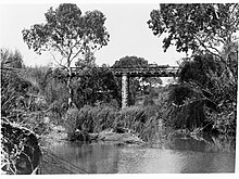
Horse and cart on Felixstow Bridge over River Torrens
Felixstow is a suburb of Adelaide, situated in the City of Norwood Payneham St Peters. It is located approximately 6.7 km (4.2 mi) from the Adelaide city centre.
It was reportedly named by Thomas Stow, who had been the first European to take up pastoral duties in the area, by combining the Latin word for "happy" with the Old English word for "place". His son, Augustine Stow, later had a vineyard at Felixstow.[2]
opened as on 1 July 1882 and was renamed on 15 August 1963.[3]
The historic (now the Aldersgate Nursing Home) is listed on the South Australian Heritage Register.[4]
References[]
- ^ Australian Bureau of Statistics (27 June 2017). "Felixstow (State Suburb)". 2016 Census QuickStats. Retrieved 3 April 2018.

- ^ "Place Names of South Australia - F". The Manning Index of South Australian History. State Library of South Australia. Retrieved 13 December 2016.
- ^ "Hectorville". Post Office Reference. Premier Postal. Retrieved 13 December 2016.
- ^ "Office ('Forsyth House', former Dwelling), Aldersgate Nursing Home". South Australian Heritage Register. Department of Environment, Water and Natural Resources. Retrieved 13 December 2016.
Coordinates: 34°53′28″S 138°38′38″E / 34.891°S 138.644°E

This article about a place in Adelaide is a stub. You can help Wikipedia by . |
Categories:
- Suburbs of Adelaide
- Adelaide geography stubs