Felthorpe
| Felthorpe | |
|---|---|
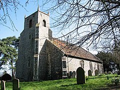 St Margaret's church | |
 Felthorpe Location within Norfolk | |
| Area | 8.70 km2 (3.36 sq mi) |
| Population | 745 (2011)[1] |
| • Density | 86/km2 (220/sq mi) |
| OS grid reference | TG169182 |
| Civil parish |
|
| District | |
| Shire county | |
| Region | |
| Country | England |
| Sovereign state | United Kingdom |
| Post town | NORWICH |
| Postcode district | NR10 |
| Police | Norfolk |
| Fire | Norfolk |
| Ambulance | East of England |

Felthorpe is a village and civil parish in the English county of Norfolk. It covers an area of 8.70 km2 (3.36 sq mi) and had a population of 710 in 287 households at the 2001 census,[2] increasing to a population of 745 in 297 households at the 2011 Census. For the purposes of local government, it falls within the district of Broadland.
The villages name means 'Faela's outlying farm/settlement'.
The parish church of St Margaret, restored in 1878, dates from the 14th century and is a grade II* listed building.[3]
In 1966, Felthorpe was the location of the first crash of a Trident jet, in which all four people on board were killed.
Notes[]
- ^ "Civil Parish population 2011". Neighbourhood Statistics. Office for National Statistics. Retrieved 3 August 2016.
- ^ Census population and household counts for unparished urban areas and all parishes. Office for National Statistics & Norfolk County Council (2001). Retrieved 20 June 2009.
- ^ Historic England. "PARISH CHURCH OF ST MARGARET (1051539)". National Heritage List for England. Retrieved 13 March 2014.
http://kepn.nottingham.ac.uk/map/place/Norfolk/Felthorpe
External links[]
![]() Media related to Felthorpe at Wikimedia Commons
Media related to Felthorpe at Wikimedia Commons
| Boroughs or districts | |
|---|---|
| Major settlements |
|
| Topics |
|
This Norfolk location article is a stub. You can help Wikipedia by . |
- Broadland
- Villages in Norfolk
- Civil parishes in Norfolk
- Norfolk geography stubs