Freethorpe
| Freethorpe | |
|---|---|
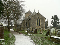 Freethorpe All Saints | |
 Freethorpe Location within Norfolk | |
| Area | 9.51 km2 (3.67 sq mi) |
| Population | 906 |
| • Density | 95/km2 (250/sq mi) |
| OS grid reference | TG409054 |
| Civil parish |
|
| District | |
| Shire county | |
| Region | |
| Country | England |
| Sovereign state | United Kingdom |
| Post town | NORWICH |
| Postcode district | NR13 |
| Police | Norfolk |
| Fire | Norfolk |
| Ambulance | East of England |

Freethorpe is a village and civil parish in the English county of Norfolk, about 8 miles (13 km) south-west of Great Yarmouth. It covers an area of 9.51 km2 (3.67 sq mi) and had a population of 906 in 363 households at the 2001 census.[1] For the purposes of local government, it falls within the district of Broadland.
The villages name means 'Fraethi's outlying farm/settlement' or perhaps, 'refuge outlying farm/settlement', ie., a place offering protection or refuge.
Its church, All Saints, is one of 124 existing round-tower churches in Norfolk.
School[]
Freethorpe Community Primary School, is the local school, which teaches Reception to Year 6 (Ages 4–11). They are currently without a head teacher. At the end of every year, the leaving Year 6's put on a performance of a well-known play/story.
Notes[]
- ^ Census population and household counts for unparished urban areas and all parishes. Office for National Statistics & Norfolk County Council (2001). Retrieved 20 June 2009.
http://kepn.nottingham.ac.uk/map/place/Norfolk/Freethorpe
External links[]
![]() Media related to Freethorpe at Wikimedia Commons
Media related to Freethorpe at Wikimedia Commons
This Norfolk location article is a stub. You can help Wikipedia by . |
- Villages in Norfolk
- Civil parishes in Norfolk
- Broadland
- Norfolk geography stubs