Ferrette
Ferrette | |
|---|---|
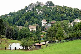 A general view of Ferrette | |
 Coat of arms | |
show Location of Ferrette | |
 Ferrette | |
| Coordinates: 47°30′N 7°19′E / 47.50°N 7.32°ECoordinates: 47°30′N 7°19′E / 47.50°N 7.32°E | |
| Country | France |
| Region | Grand Est |
| Department | Haut-Rhin |
| Arrondissement | Altkirch |
| Canton | Altkirch |
| Government | |
| • Mayor (2020–2026) | Corinne Rabault[1] |
| Area 1 | 1.94 km2 (0.75 sq mi) |
| Population (Jan. 2018)[2] | 770 |
| • Density | 400/km2 (1,000/sq mi) |
| Time zone | UTC+01:00 (CET) |
| • Summer (DST) | UTC+02:00 (CEST) |
| INSEE/Postal code | 68090 /68480 |
| Elevation | 429–640 m (1,407–2,100 ft) (avg. 550 m or 1,800 ft) |
| 1 French Land Register data, which excludes lakes, ponds, glaciers > 1 km2 (0.386 sq mi or 247 acres) and river estuaries. | |


Ferrette (French pronunciation: [fɛʁɛt]; German: ![]() Pfirt (help·info); Alsatian: Pfìrt) is a commune in the Haut-Rhin department in Alsace in north-eastern France.
Pfirt (help·info); Alsatian: Pfìrt) is a commune in the Haut-Rhin department in Alsace in north-eastern France.
It is situated close to the Swiss border. Its main attraction is the Château de Ferrette.
County of Ferrette[]
The County of Ferrette came into existence in the 11th century and consisted of a large part of southern Alsace. In 1324, the County was acquired by Austria through the marriage of Jeanne, Countess of Ferrette, with Albert II, Duke of Austria. The County was part of the dowry for Catherine of Burgundy upon her marriage to Duke Leopold IV.[3] Upon Leopold's death in 1411, his brother, Frederick occupied Ferrette.[3] Austria ceded it to France in the Peace of Westphalia of 1648.
See also[]
References[]
- ^ "Répertoire national des élus: les maires". data.gouv.fr, Plateforme ouverte des données publiques françaises (in French). 2 December 2020.
- ^ "Populations légales 2018". INSEE. 28 December 2020.
- ^ Jump up to: a b Richard Vaughan, Philip the Good: The Apogee of Burgundy, (The Boydell Press, 2002), 31.
| Wikimedia Commons has media related to Ferrette. |
| show |
|---|
| show Authority control |
|---|
This Haut-Rhin geographical article is a stub. You can help Wikipedia by . |
- Communes of Haut-Rhin
- History of Alsace
- Haut-Rhin geography stubs