Ferris, Texas
Ferris, Texas | |
|---|---|
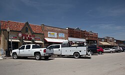 Downtown Ferris, Texas | |
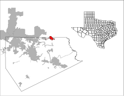
 Location of Ferris, Texas | |
 | |
| Coordinates: 32°32′7″N 96°40′1″W / 32.53528°N 96.66694°WCoordinates: 32°32′7″N 96°40′1″W / 32.53528°N 96.66694°W | |
| Country | United States |
| State | Texas |
| Counties | Ellis, Dallas |
| Area | |
| • Total | 4.78 sq mi (12.37 km2) |
| • Land | 4.63 sq mi (12.01 km2) |
| • Water | 0.14 sq mi (0.37 km2) |
| Elevation | 466 ft (142 m) |
| Population (2010) | |
| • Total | 2,436 |
| • Estimate (2019)[2] | 2,974 |
| • Density | 641.64/sq mi (247.73/km2) |
| Time zone | UTC-6 (Central (CST)) |
| • Summer (DST) | UTC-5 (CDT) |
| ZIP code | 75125 |
| Area code(s) | 972 |
| FIPS code | 48-25752[3] |
| GNIS feature ID | 1335757[4] |
| Website | www |

Ferris is a city in Dallas and Ellis counties in the U.S. state of Texas. It is 20 miles (32 km) south of downtown Dallas. The population was 2,436 at the 2010 census.[5]
Geography[]
Ferris is located at 32°32′7″N 96°40′1″W / 32.53528°N 96.66694°W (32.535144, −96.667038).[6]
According to the United States Census Bureau, the city has a total area of 4.8 square miles (12.4 km2), of which 4.6 square miles (12.0 km2) is land and 0.15 square miles (0.4 km2) is water.[7] Most of the city lies within Ellis County, with only a small portion in Dallas County.
History[]
Settlement of the area began in the early 1870s. On September 28, 1874, a local family deeded approximately 100 acres (0.40 km2) of land to four trustees for the establishment of a town and railway station.[8] Judge Justus Wesley Ferris of Waxahachie handled the transaction, and the community was named for him. Within ten years, Ferris had a population of 300 with a post office, gristmills, cotton gins, four churches, and a school.[9]
On September 18, 1882, an election was held to incorporate the community. A total of 47 votes were cast – 34 (72%) in favor of incorporation and 13 (28%) against.[8] The results were verified by the Ellis County Judge on September 30, and Ferris officially became a town. By 1900, the town was home to 904 residents. In 1910, that number had increased to 1,233 residents.[9]
Fifty businesses, including six brick plants that benefitted from the area's mineral rich soil, were operating in 1914. The population rose to 1,586 by 1925 but declined during the 1930s and 1940s as a result of the Great Depression and World War II.[10]
Ferris thrived during the early post-war years. Four brick plants operated during the 1950s, and the community was known locally as the "Brick Capital of the Nation".[9] Ferris also has a second nickname – "The City that Bricked the World" – which is still commonly used to date. In 1952, the population had risen to 1,734 and 1,807 by 1964. The Ferris Annual Brick Festival is held every year at the end of April.[10]
The expansion of the Dallas–Fort Worth Metropolitan Area and the construction of Interstate 45 aided the growth of Ferris in the latter half of the twentieth century. Although the number of businesses decreased during the 1980s, the population continued to grow. It stood at 2,212 in 1990, 2,175 in 2000,[9] and 2,436 in 2010.[5] In 1994, Ferris won the 3-A State Championship in men's basketball.
Demographics[]
| Historical population | |||
|---|---|---|---|
| Census | Pop. | %± | |
| 1880 | 106 | — | |
| 1890 | 311 | 193.4% | |
| 1900 | 904 | 190.7% | |
| 1910 | 1,233 | 36.4% | |
| 1920 | 1,586 | 28.6% | |
| 1930 | 1,438 | −9.3% | |
| 1940 | 1,436 | −0.1% | |
| 1950 | 1,735 | 20.8% | |
| 1960 | 1,807 | 4.1% | |
| 1970 | 2,155 | 19.3% | |
| 1980 | 2,228 | 3.4% | |
| 1990 | 2,212 | −0.7% | |
| 2000 | 2,175 | −1.7% | |
| 2010 | 2,436 | 12.0% | |
| 2019 (est.) | 2,974 | [2] | 22.1% |
| U.S. Decennial Census[11] | |||
In 2010 Ferris had a population of 2,436. The racial and ethnic composition of the population was 42.7% non-Hispanic white, 17.5% non-Hispanic black, 1% Hispanic black, 0.3% Native American, 0.2% Asian, 1.8% from two or more races and 38.4% Hispanic or Latino.[12]
As of the census[3] of 2000, there were 2,175 people, 688 households, and 502 families residing in the city. The population density was 699.8 people per square mile (270.0/km2). There were 741 housing units at an average density of 238.4/sq mi (92.0/km2). The racial makeup of the city was 67.68% White, 22.39% African American, 0.23% Native American, 0.46% Asian, 7.45% from other races, and 1.79% from two or more races. Hispanic or Latino of any race were 27.54% of the population.
There were 688 households, out of which 41.0% had children under the age of 18 living with them, 49.9% were married couples living together, 17.9% had a female householder with no husband present, and 26.9% were non-families. 22.5% of all households were made up of individuals, and 9.7% had someone living alone who was 65 years of age or older. The average household size was 3.06 and the average family size was 3.61.
In the city, the population was spread out, with 32.0% under the age of 18, 9.7% from 18 to 24, 28.7% from 25 to 44, 17.7% from 45 to 64, and 11.9% who were 65 years of age or older. The median age was 31 years. For every 100 females, there were 86.5 males. For every 100 females age 18 and over, there were 84.4 males.
The median income for a household in the city was $36,573, and the median income for a family was $43,641. Males had a median income of $32,227 versus $24,423 for females. The per capita income for the city was $18,104. About 8.1% of families and 12.2% of the population were below the poverty line, including 14.5% of those under age 18 and 11.1% of those age 65 or over.
Education[]
Pupils in Ferris are served by the Ferris Independent School District.
Some areas in Dallas County not within the Ferris city limits but with Ferris addresses are served by the Dallas Independent School District. The areas were served by the Wilmer-Hutchins Independent School District until it closed for good during the 2005–2006 school year.
The designated community college for Ellis County is Navarro College. The designated community college for Dallas County is Dallas College (formerly Dallas County Community College District or DCCCD).[13]
Photo gallery[]

City Hall

Downtown

Downtown
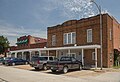
Downtown

Ferris Presbyterian Church


Transportation[]
Major highways[]
Air[]
The city of Ferris jointly owns the Ferris Red Oak Muni Heliport together with the city of Red Oak.[14] Ferris is also served by the privately owned Dallas South Port Airport.[15]
Climate[]
The climate in this area is characterized by hot, humid summers and generally mild to cool winters. According to the Köppen Climate Classification system, Ferris has a humid subtropical climate, abbreviated "Cfa" on climate maps.[16]
Notable people[]
- Guilherme Marchi, Professional bull rider and 2008 PBR world champion.
- Homer P. Rainey, Former University of Texas president; briefly attended Ferris High School.
References[]
- ^ "2019 U.S. Gazetteer Files". United States Census Bureau. Retrieved August 7, 2020.
- ^ a b "Population and Housing Unit Estimates". United States Census Bureau. May 24, 2020. Retrieved May 27, 2020.
- ^ a b "U.S. Census website". United States Census Bureau. Retrieved 2008-01-31.
- ^ "US Board on Geographic Names". United States Geological Survey. 2007-10-25. Retrieved 2008-01-31.
- ^ a b "Profile of General Population and Housing Characteristics: 2010 Demographic Profile Data (DP-1): Ferris city, Texas". United States Census Bureau. Retrieved January 12, 2012.
- ^ "US Gazetteer files: 2010, 2000, and 1990". United States Census Bureau. 2011-02-12. Retrieved 2011-04-23.
- ^ "Geographic Identifiers: 2010 Demographic Profile Data (G001): Ferris city, Texas". United States Census Bureau. Retrieved January 12, 2012.
- ^ a b The Story of Ferris, Texas – Ellis County TXGenWeb.
- ^ a b c d Ferris, Texas – Handbook of Texas.
- ^ a b Ferris, Texas – Texas Escapes Online Magazine.
- ^ "Census of Population and Housing". Census.gov. Retrieved June 4, 2015.
- ^ 2010 general population and housing profile for Ferris from the US Census
- ^ Texas Education Code Sec. 130.176. DALLAS COUNTY COMMUNITY COLLEGE DISTRICT SERVICE AREA. Sec. 130.189. NAVARRO COLLEGE DISTRICT SERVICE AREA.
- ^ FAA Airport Form 5010 for 12T PDF. Federal Aviation Administration. Effective 26 April 2018.
- ^ FAA Airport Form 5010 for T13 PDF. Federal Aviation Administration, Effective 26 April 2018.
- ^ Climate Summary for Ferris, Texas
External links[]
| Wikimedia Commons has media related to Ferris, Texas. |
- City of Ferris official website
- Read the Ferris Wheel newspaper, 1896–1897, hosted by the Portal to Texas History
Municipalities and communities of Dallas County, Texas, United States | ||
|---|---|---|
| Cities |  | |
| Towns | ||
| CDP | ||
| Unincorporated community | ||
| Historical communities |
| |
| Footnotes | ‡This populated place also has portions in an adjacent county or counties | |
| ||
Municipalities and communities of Ellis County, Texas, United States | ||
|---|---|---|
| Cities |  | |
| Towns | ||
| CDP | ||
| Other communities | ||
| Footnotes | ‡This populated place also has portions in an adjacent county or counties | |
| ||
- Dallas–Fort Worth metroplex
- Cities in Dallas County, Texas
- Cities in Ellis County, Texas
- Cities in Texas
- Populated places established in 1874
- 1874 establishments in Texas