Ferrol, Romblon
Ferrol | |
|---|---|
| Municipality of Ferrol | |
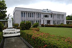 Municipal Hall | |
 Map of Romblon with Ferrol highlighted | |
OpenStreetMap  | |
 Ferrol Location within the Philippines | |
| Coordinates: 12°20′18″N 121°56′19″E / 12.33833°N 121.93861°ECoordinates: 12°20′18″N 121°56′19″E / 12.33833°N 121.93861°E | |
| Country | Philippines |
| Region | Mimaropa |
| Province | Romblon |
| District | Lone district |
| Founded | 1850 |
| Incorporated | 1978 |
| Barangays | 6 (see Barangays) |
| Government | |
| • Type | Sangguniang Bayan |
| • Mayor | Jovencio "Jun" L. Mayor Jr. |
| • Vice Mayor | Antonio F. Compas |
| • Councilors |
|
| • Electorate | 4,583 voters (2019) |
| Area | |
| • Total | 26.72 km2 (10.32 sq mi) |
| Elevation | 31 m (102 ft) |
| Highest elevation | 622 m (2,041 ft) |
| Lowest elevation | 0 m (0 ft) |
| Population (2020 census) [3] | |
| • Total | 8,005 |
| • Density | 300/km2 (780/sq mi) |
| • Households | 1,653 |
| Economy | |
| • Income class | 6th municipal income class |
| • Poverty incidence | 33.17% (2015)[4] |
| • Revenue | ₱57,087,157.36 (2020) |
| • Assets | ₱199,373,817.33 (2020) |
| • Expenditure | ₱49,792,515.19 (2020) |
| • Liabilities | ₱24,179,664.97 (2020) |
| Service provider | |
| • Electricity | Tablas Island Electric Cooperative (TIELCO) |
| Time zone | UTC+8 (PST) |
| ZIP code | 5506 |
| PSGC | |
| IDD : area code | +63 (0)42 |
| Native languages | Onhan Tagalog |

Ferrol, officially the Municipality of Ferrol, is a 6th class municipality in the province of Romblon, Philippines. According to the 2020 census, it has a population of 8,005 people. [3]
History[]
Ferrol was established in 1850 as a barrio of Odiongan municipality by Spanish colonial authorities. They discovered the place some 10 kilometers south-west after repulsing and chasing a convoy of Muslim pirates that attacked Odiongan. The Spanish noted the resemblance of the bay in the vicinity to the bay of Ferrol, Spain, which is the home port of Spain's Maritime Department of the North, hence the town's name.[5]
In 1978, in order to consolidate the Onhan-speaking barangays of Odiongan into one municipality, Assemblyman Nemesio Ganan Jr. authored a bill in the Congress of the Philippines which created Ferrol, together with the barangays of Agnocnoc, Bunsoran, Hinagoman, Tubigon, and Claro M. Recto in a new municipality. On 11 June 1978, Ferrol formally became the 16th municipality in Romblon by virtue of Presidential Decree No. 1492, signed by President Ferdinand Marcos.[6]
Geography[]
Ferrol is located on Tablas Island. It is bounded on the north by Odiongan, on the west by the Tablas Strait, on the east by Santa Maria, and on the south by Looc. It has a total land area of 26.72 km2.
Barangays[]

Ferrol is politically subdivided into 6 barangays:
- Agnonoc
- Bunsoran
- Claro M. Recto
- Poblacion
- Hinaguman
- Tubigon
Climate[]
| Climate data for Ferrol, Romblon | |||||||||||||
|---|---|---|---|---|---|---|---|---|---|---|---|---|---|
| Month | Jan | Feb | Mar | Apr | May | Jun | Jul | Aug | Sep | Oct | Nov | Dec | Year |
| Average high °C (°F) | 28 (82) |
29 (84) |
30 (86) |
31 (88) |
31 (88) |
30 (86) |
29 (84) |
29 (84) |
29 (84) |
29 (84) |
29 (84) |
28 (82) |
29 (85) |
| Average low °C (°F) | 21 (70) |
21 (70) |
22 (72) |
23 (73) |
25 (77) |
25 (77) |
25 (77) |
25 (77) |
25 (77) |
24 (75) |
23 (73) |
22 (72) |
23 (74) |
| Average precipitation mm (inches) | 31 (1.2) |
20 (0.8) |
25 (1.0) |
39 (1.5) |
152 (6.0) |
269 (10.6) |
314 (12.4) |
285 (11.2) |
303 (11.9) |
208 (8.2) |
95 (3.7) |
70 (2.8) |
1,811 (71.3) |
| Average rainy days | 9.5 | 7.1 | 9.0 | 11.3 | 21.0 | 25.7 | 28.1 | 26.5 | 27.3 | 24.6 | 16.5 | 12.1 | 218.7 |
| Source: Meteoblue [7] | |||||||||||||
Demographics[]
| Year | Pop. | ±% p.a. |
|---|---|---|
| 1980 | 4,840 | — |
| 1990 | 5,621 | +1.51% |
| 1995 | 5,772 | +0.50% |
| 2000 | 5,924 | +0.56% |
| 2007 | 6,395 | +1.06% |
| 2010 | 6,802 | +2.27% |
| 2015 | 6,964 | +0.45% |
| 2020 | 8,005 | +2.78% |
| Source: Philippine Statistics Authority [8] [9] [10][11] | ||
According to the 2015 census, it has a population of 6,964 people. Onhan, together with Tagalog, Hiligaynon, and English, is the medium of communication in business and trade.
Economy[]
| Poverty Incidence of Ferrol | |
| Source: Philippine Statistics Authority[12][13][14][15][16][17] | |
Ferrol has the highest level of vegetable production in Romblon. Livestock and rice farming are also present in the coastal areas which is mostly for home consumption and grown in small scale. Other economic opportunities include copra farming, fish cultivation, agricultural manufacturing and retail, and tourism. The Tablas Island Electric cooperative supplies 41.78% of households in Ferrol with electricity. As for water supply, the town has a Level 3 water supply system and a Level 4 irrigation system with 75 service areas.[5]
Landline and cellular phone services from PLDT, Smart, and Globe are already available in Ferrol. The town is connected to nearby Odiongan and other municipalities through the Tablas Circumferential Road. Jeepneys and tricycles are the common form of land transportation. A port in Barangay Agnocnoc caters to intra-provincial travel and fishing vessels.[5]
Tourist attractions and transport[]
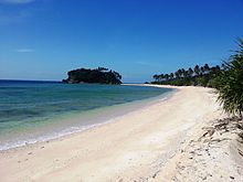
Beaches near Ferrol include Binucot, Atabay and Guin-awayan beaches. Caves the Mabaho and Burobintana caves. The town is accessible via Odiongan by RORO vessels from Batangas City or Roxas, Oriental Mindoro.[5] It is also accessible via Tugdan Airport in Alcantara town, where Cebu Pacific has flights from Manila four times weekly.[18]
Local government[]
Pursuant to Chapter II, Title II, Book III of Republic Act 7160 or the Local Government Code of 1991,[19] the municipal government is composed of a mayor (alkalde), a vice mayor (bise alkalde) and members (kagawad) of the legislative branch Sangguniang Bayan alongside a secretary to the said legislature, all of which are elected to a three-year term and are eligible to run for three consecutive terms.
Jovencio "Jun" Mayor, Jr. and Antonio Compas of the PDP–Laban, are the incumbent mayor and vice mayor of Ferrol as of 30 June 2019.
References[]
- ^ Municipality of Ferrol | (DILG)
- ^ "2015 Census of Population, Report No. 3 – Population, Land Area, and Population Density" (PDF). Philippine Statistics Authority. Quezon City, Philippines. August 2016. ISSN 0117-1453. Archived (PDF) from the original on May 25, 2021. Retrieved July 16, 2021.
- ^ a b Census of Population (2020). "MIMAROPA". Total Population by Province, City, Municipality and Barangay. PSA. Retrieved 8 July 2021.
- ^ https://psa.gov.ph/sites/default/files/City%20and%20Municipal-level%20Small%20Area%20Poverty%20Estimates_%202009%2C%202012%20and%202015_0.xlsx; publication date: 10 July 2019; publisher: Philippine Statistics Authority.
- ^ a b c d Fabula, Milex (2001). "Profile: Ferrol". Romblon Travel Guide. Retrieved 22 August 2014.
- ^ A Decree Creating the Municipality of Ferrol in the Province of Romblon ChanRobles.com. Retrieved on 2012-04-17.
- ^ "Ferrol: Average Temperatures and Rainfall". Meteoblue. Retrieved 28 April 2020.
- ^ Census of Population (2015). "Region IV-B (Mimaropa)". Total Population by Province, City, Municipality and Barangay. PSA. Retrieved 20 June 2016.
- ^ Census of Population and Housing (2010). "Region IV-B (Mimaropa)". Total Population by Province, City, Municipality and Barangay. NSO. Retrieved 29 June 2016.
- ^ Censuses of Population (1903–2007). "Region IV-B (Mimaropa)". Table 1. Population Enumerated in Various Censuses by Province/Highly Urbanized City: 1903 to 2007. NSO.
- ^ "Province of Romblon". Municipality Population Data. Local Water Utilities Administration Research Division. Retrieved 17 December 2016.
- ^ "Poverty incidence (PI):". Philippine Statistics Authority. Retrieved 28 December 2020.
- ^ https://psa.gov.ph/sites/default/files/NSCB_LocalPovertyPhilippines_0.pdf; publication date: 29 November 2005; publisher: Philippine Statistics Authority.
- ^ https://psa.gov.ph/sites/default/files/2003%20SAE%20of%20poverty%20%28Full%20Report%29_1.pdf; publication date: 23 March 2009; publisher: Philippine Statistics Authority.
- ^ https://psa.gov.ph/sites/default/files/2006%20and%202009%20City%20and%20Municipal%20Level%20Poverty%20Estimates_0_1.pdf; publication date: 3 August 2012; publisher: Philippine Statistics Authority.
- ^ https://psa.gov.ph/sites/default/files/2012%20Municipal%20and%20City%20Level%20Poverty%20Estima7tes%20Publication%20%281%29.pdf; publication date: 31 May 2016; publisher: Philippine Statistics Authority.
- ^ https://psa.gov.ph/sites/default/files/City%20and%20Municipal-level%20Small%20Area%20Poverty%20Estimates_%202009%2C%202012%20and%202015_0.xlsx; publication date: 10 July 2019; publisher: Philippine Statistics Authority.
- ^ "Cebu Pacific adds Masbate, Tablas to route network". Manila Bulletin. December 13, 2016. Retrieved 12 January 2017.
- ^ "An Act Providing for a Local Government Code of 1991". The LawPhil Project. 8th Congress of the Republic of the Philippines. Retrieved April 21, 2014.
External links[]
| Wikimedia Commons has media related to Ferrol, Romblon. |
- Ferrol Profile at PhilAtlas.com
- Philippine Standard Geographic Code
- Philippine Census Information
- Local Governance Performance Management System
Places adjacent to Ferrol, Romblon | ||||||||||||||||
|---|---|---|---|---|---|---|---|---|---|---|---|---|---|---|---|---|
| ||||||||||||||||
- Municipalities of Romblon