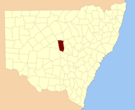
Flinders County

From Wikipedia, the free encyclopedia

Map all coordinates using: OpenStreetMap 
Download coordinates as: KML
Flinders
New South Wales
Flinders NSW.PNG
Location in New South Wales
Lands administrative divisions around Flinders:
Robinson Canbelego Oxley
Mouramba Flinders Kennedy
Blaxland Cunningham Kennedy

Flinders County is one of the 141 Cadastral divisions of New South Wales. It is located to the south west of the Bogan River.

Flinders County was named in honour of the navigator, hydrographer, and scientist Matthew Flinders (1774-1814).[1]

Parishes within this county[]

A full list of parishes found within this county; their current LGA and mapping coordinates to the approximate centre of each location is as follows:

Parish LGA Coordinates
Bogan Shire 31°57′54″S 146°32′04″E / 31.96500°S 146.53444°E / -31.96500; 146.53444 (Babego)
Bogan Shire 31°57′54″S 146°30′04″E / 31.96500°S 146.50111°E / -31.96500; 146.50111 (Babinda)
Bogan Shire 32°07′54″S 147°00′04″E / 32.13167°S 147.00111°E / -32.13167; 147.00111 (Balgay)
Bogan Shire 31°51′54″S 146°30′04″E / 31.86500°S 146.50111°E / -31.86500; 146.50111 (Barrow)
Bogan Shire 31°49′54″S 146°38′04″E / 31.83167°S 146.63444°E / -31.83167; 146.63444 (Bebri)
Lachlan Shire 32°08′54″S 147°10′04″E / 32.14833°S 147.16778°E / -32.14833; 147.16778 (Belah)
Bogan Shire 31°37′54″S 146°50′04″E / 31.63167°S 146.83444°E / -31.63167; 146.83444 (Birrigan)
Bogan Shire 31°33′54″S 146°42′04″E / 31.56500°S 146.70111°E / -31.56500; 146.70111 (Boree)
Bogan Shire 31°33′54″S 146°34′04″E / 31.56500°S 146.56778°E / -31.56500; 146.56778 (Budgery)
Bogan Shire 32°02′54″S 147°09′04″E / 32.04833°S 147.15111°E / -32.04833; 147.15111 (Budtha)
Lachlan Shire 32°14′54″S 147°10′04″E / 32.24833°S 147.16778°E / -32.24833; 147.16778 (Bulbodny)
Bogan Shire 31°43′39″S 146°23′59″E / 31.72750°S 146.39972°E / -31.72750; 146.39972 (Bulga)
Lachlan Shire 32°23′54″S 147°07′04″E / 32.39833°S 147.11778°E / -32.39833; 147.11778 (Bumbaldry)
Lachlan Shire 32°23′54″S 147°00′04″E / 32.39833°S 147.00111°E / -32.39833; 147.00111 (Burra)
Bogan Shire 32°19′37″S 146°44′07″E / 32.32694°S 146.73528°E / -32.32694; 146.73528 (Cameron)
Bogan Shire 31°45′54″S 146°34′04″E / 31.76500°S 146.56778°E / -31.76500; 146.56778 (Condon)
Bogan Shire 31°55′54″S 146°56′04″E / 31.93167°S 146.93444°E / -31.93167; 146.93444 (Coolibah)
Bogan Shire 31°57′54″S 146°36′04″E / 31.96500°S 146.60111°E / -31.96500; 146.60111 (Crowie)
Bogan Shire 32°06′28″S 146°30′25″E / 32.10778°S 146.50694°E / -32.10778; 146.50694 (Cumbine)
Bogan Shire 32°04′21″S 146°52′02″E / 32.07250°S 146.86722°E / -32.07250; 146.86722 (Currajong)
Delby Bogan Shire 32°15′57″S 146°43′29″E / 32.26583°S 146.72472°E / -32.26583; 146.72472 (Delby)
Bogan Shire 31°43′54″S 146°30′04″E / 31.73167°S 146.50111°E / -31.73167; 146.50111 (Egeria)
Bogan Shire 31°53′54″S 146°32′04″E / 31.89833°S 146.53444°E / -31.89833; 146.53444 (Firbank)
Bogan Shire 31°33′54″S 146°46′04″E / 31.56500°S 146.76778°E / -31.56500; 146.76778 (Foster)
Bogan Shire 31°38′34″S 146°23′38″E / 31.64278°S 146.39389°E / -31.64278; 146.39389 (Geweroo)
Gilgai Bogan Shire 31°37′54″S 147°01′04″E / 31.63167°S 147.01778°E / -31.63167; 147.01778 (Gilgai)
Gilgai Bogan Shire 31°35′54″S 146°58′04″E / 31.59833°S 146.96778°E / -31.59833; 146.96778 (Gilgai)
Grahway Bogan Shire 32°14′21″S 146°33′05″E / 32.23917°S 146.55139°E / -32.23917; 146.55139 (Grahway)
Bogan Shire 31°39′54″S 146°40′04″E / 31.66500°S 146.66778°E / -31.66500; 146.66778 (Grayrigg)
Hermitage Bogan Shire 31°55′54″S 146°48′04″E / 31.93167°S 146.80111°E / -31.93167; 146.80111 (Hermitage)
Bogan Shire 31°53′54″S 146°42′04″E / 31.89833°S 146.70111°E / -31.89833; 146.70111 (Hermitage Plains)
Bogan Shire 31°49′54″S 146°56′04″E / 31.83167°S 146.93444°E / -31.83167; 146.93444 (Honeybugle)
Bogan Shire 31°51′54″S 147°01′04″E / 31.86500°S 147.01778°E / -31.86500; 147.01778 (Honeybugle)
Bogan Shire 31°47′54″S 146°30′04″E / 31.79833°S 146.50111°E / -31.79833; 146.50111 (Howgill)
Bogan Shire 31°41′54″S 146°56′04″E / 31.69833°S 146.93444°E / -31.69833; 146.93444 (Keenan)
Bogan Shire 31°43′54″S 147°02′04″E / 31.73167°S 147.03444°E / -31.73167; 147.03444 (Keenan)
Bogan Shire 32°07′56″S 146°43′28″E / 32.13222°S 146.72444°E / -32.13222; 146.72444 (Kinnear)
Bogan Shire 31°39′54″S 146°34′04″E / 31.66500°S 146.56778°E / -31.66500; 146.56778 (Lambrigg)
Bogan Shire 31°55′54″S 147°04′04″E / 31.93167°S 147.06778°E / -31.93167; 147.06778 (Merrilba)
Lachlan Shire 32°20′52″S 146°54′39″E / 32.34778°S 146.91083°E / -32.34778; 146.91083 (Miamley North)
Bogan Shire 31°37′54″S 147°06′04″E / 31.63167°S 147.10111°E / -31.63167; 147.10111 (Miandetta)
Lachlan Shire 32°18′54″S 147°10′04″E / 32.31500°S 147.16778°E / -32.31500; 147.16778 (Minalong)
Lachlan Shire 32°18′38″S 146°50′52″E / 32.31056°S 146.84778°E / -32.31056; 146.84778 (Mogille)
Lachlan Shire 32°20′54″S 147°00′04″E / 32.34833°S 147.00111°E / -32.34833; 147.00111 (Mogille Plain)
Lachlan Shire 32°15′04″S 146°51′07″E / 32.25111°S 146.85194°E / -32.25111; 146.85194 (Mogundale)
Bogan Shire 31°45′54″S 146°36′04″E / 31.76500°S 146.60111°E / -31.76500; 146.60111 (Mullah)
Bogan Shire 31°43′54″S 147°06′04″E / 31.73167°S 147.10111°E / -31.73167; 147.10111 (Murrabudda)
Bogan Shire 32°02′54″S 147°04′04″E / 32.04833°S 147.06778°E / -32.04833; 147.06778 (Myall Cowall)
Bogan Shire 32°19′57″S 146°35′48″E / 32.33250°S 146.59667°E / -32.33250; 146.59667 (Nangerybone)
Nardoo Bogan Shire 31°41′54″S 146°48′04″E / 31.69833°S 146.80111°E / -31.69833; 146.80111 (Nardoo)
Lachlan Shire 32°17′54″S 147°03′04″E / 32.29833°S 147.05111°E / -32.29833; 147.05111 (Oberon)
Bogan Shire 31°57′54″S 146°42′04″E / 31.96500°S 146.70111°E / -31.96500; 146.70111 (Pangee)
Bogan Shire 31°49′54″S 146°46′04″E / 31.83167°S 146.76778°E / -31.83167; 146.76778 (Pangee Creek)
Bogan Shire 31°43′54″S 146°42′04″E / 31.73167°S 146.70111°E / -31.73167; 146.70111 (Quanda)
Quondong Bogan Shire 31°45′54″S 146°52′04″E / 31.76500°S 146.86778°E / -31.76500; 146.86778 (Quondong)
Bogan Shire 31°57′54″S 146°56′04″E / 31.96500°S 146.93444°E / -31.96500; 146.93444 (Red Gilgais)
Bogan Shire 32°01′54″S 147°00′04″E / 32.03167°S 147.00111°E / -32.03167; 147.00111 (Red Gilgais)
Bogan Shire 31°51′54″S 146°52′04″E / 31.86500°S 146.86778°E / -31.86500; 146.86778 (Regan)
Bogan Shire 32°10′30″S 146°52′11″E / 32.17500°S 146.86972°E / -32.17500; 146.86972 (Talgong)
Lachlan Shire 32°27′42″S 146°53′02″E / 32.46167°S 146.88389°E / -32.46167; 146.88389 (The Bluff)
The Overflow Bogan Shire 32°12′05″S 146°38′31″E / 32.20139°S 146.64194°E / -32.20139; 146.64194 (The Overflow)
Bogan Shire 32°07′54″S 147°04′04″E / 32.13167°S 147.06778°E / -32.13167; 147.06778 (Umang)
Bogan Shire 32°23′45″S 146°47′29″E / 32.39583°S 146.79139°E / -32.39583; 146.79139 (Walkers Hill)
Walton Bogan Shire 32°10′26″S 146°34′16″E / 32.17389°S 146.57111°E / -32.17389; 146.57111 (Walton)
Bogan Shire 32°06′04″S 146°36′55″E / 32.10111°S 146.61528°E / -32.10111; 146.61528 (Walwa)
Wharfdale Bogan Shire 32°12′54″S 147°02′04″E / 32.21500°S 147.03444°E / -32.21500; 147.03444 (Wharfdale)
Wharfdale North Bogan Shire 32°11′33″S 146°57′19″E / 32.19250°S 146.95528°E / -32.19250; 146.95528 (Wharfdale North)
Bogan Shire 31°33′54″S 146°50′04″E / 31.56500°S 146.83444°E / -31.56500; 146.83444 (Whitbarrow)
Bogan Shire 31°57′54″S 146°58′04″E / 31.96500°S 146.96778°E / -31.96500; 146.96778 (Wicklow)
Bogan Shire 31°59′54″S 147°00′04″E / 31.99833°S 147.00111°E / -31.99833; 147.00111 (Wicklow)
Bogan Shire 31°49′54″S 147°02′04″E / 31.83167°S 147.03444°E / -31.83167; 147.03444 (Widgeland)
Wilmatha Lachlan Shire 32°27′54″S 147°03′04″E / 32.46500°S 147.05111°E / -32.46500; 147.05111 (Wilmatha)
Bogan Shire 31°39′54″S 146°30′04″E / 31.66500°S 146.50111°E / -31.66500; 146.50111 (Winfell)
Bogan Shire 31°37′54″S 146°44′04″E / 31.63167°S 146.73444°E / -31.63167; 146.73444 (Yamma)
Bogan Shire 31°55′54″S 146°36′04″E / 31.93167°S 146.60111°E / -31.93167; 146.60111 (Yarrow)
Bogan Shire 31°33′54″S 146°30′04″E / 31.56500°S 146.50111°E / -31.56500; 146.50111 (Yoongee)

References[]

  1. ^ "Flinders County". Geographical Names Register (GNR) of NSW. Geographical Names Board of New South Wales. Edit this at Wikidata
Retrieved from ""