Geography of Fiji
 | |
| Continent | Pacific Ocean |
|---|---|
| Region | Oceania |
| Coordinates | 18°00′S 179°00′E / 18.000°S 179.000°E |
| Area | Ranked 151st |
| • Total | 18,272 km2 (7,055 sq mi) |
| • Land | 100% |
| • Water | 0% |
| Coastline | 1,129 km (702 mi) |
| Borders | None |
| Highest point | Mount Tomanivi 1,324 metres (4,344 ft) |
| Lowest point | Pacific Ocean 0 m |
| Exclusive economic zone | 1,282,978 km2 (495,361 sq mi) |


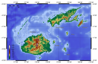
Fiji is a group of volcanic islands in the South Pacific, lying about 4,450 kilometres (2,765 mi) southwest of Honolulu and 1,770 km (1,100 mi) north of New Zealand. Of the 332 islands and 522 smaller islets making up the archipelago, about 106 are permanently inhabited.[1] The total land size is 18,272 km2 (7,055 sq mi). It has the 26th largest Exclusive Economic Zone of 1,282,978 km2 (495,361 sq mi).
Viti Levu, the largest island, covers about 57% of the nation's land area, hosts the two official cities (the capital Suva, and Lautoka) and most other major towns, such as Nausori, Vaileka, Ba, Tavua, Kororvou, Nasinu, and Nadi (the site of the international airport), and contains some 69% of the population. Vanua Levu, 64 km (40 mi) to the north of Viti Levu, covers just over 30% of the land area though is home to only some 15% of the population. Its main towns are Labasa and Savusavu. In the northeast it features Natewa Bay, carving out the Loa peninsula.
Both islands are mountainous, with peaks up to 1,300 m (4,300 ft) rising abruptly from the shore, and covered with tropical forests. Heavy rains (up to 304 cm or 120 inches annually) fall on the windward (southeastern) side, covering these sections of the islands with dense tropical forest. Lowlands on the western portions of each of the main islands are sheltered by the mountains and have a well-marked dry season favorable to crops such as sugarcane.
Other islands and island groups, which cover just 12.5% of the land area and house some 16% of the population, include Taveuni southeast off Vanua Levu and Kadavu Island, south off Viti Levu (the third and fourth largest islands respectively), the Mamanuca Group (just off Nadi) and Yasawa Group (to the north of the Mamanucas), which are popular tourist destinations, the Lomaiviti Group (just off Suva) with Levuka, the former capital and the only major town on any of the smaller islands, located on the island of Ovalau, and the remote Lau Group over the Koro Sea to the east near Tonga, from which it is separated by the .
Two outlying regions are Rotuma, 400 km (250 mi) to the north, and the uninhabited coral atoll and cay Ceva-i-Ra or Conway Reef, 450 km (280 mi) to the southwest of main Fiji. Culturally conservative Rotuma with its 2,000 people on 44 km2 (17 sq mi) geographically belongs to Polynesia, and enjoys relative autonomy as a Fijian dependency.
Fiji Television reported on 21 September 2006 that the Fiji Islands Maritime and Safety Administration (FIMSA), while reviewing its outdated maritime charts, had discovered the possibility that more islands could lie within Fiji's Exclusive Economic Zone.[citation needed]
More than half of Fiji's population lives on the island coasts, either in Suva or in smaller urban centers. The interior is sparsely populated because of its rough terrain.
Statistics[]
- Location
- Oceania, island group in the South Pacific Ocean; Geographic coordinates:
- 18°00′S 179°00′E / 18.000°S 179.000°E
- Map references
- Oceania
- Area
-
- Total: 18,274 km2 (7,056 sq mi)
- Land: 18,274 km2 (7,056 sq mi)[2]
- Water: 0 km2 (0 sq mi)
- Area – comparative
- Slightly smaller than New Jersey; slightly less than one third Nova Scotia's size; slightly smaller than Wales
- Land boundaries
- 0 km (0 mi)
- Coastline
- 1,129 km (702 mi)
- Maritime claims
-
- Measured from claimed archipelagic baselines
- Territorial sea: 12 nautical miles (22 km; 14 mi)
- Exclusive economic zone: 1,282,978 km2 (495,361 sq mi). 200 nmi (370 km; 230 mi)
- Continental shelf: 200 m (660 ft) depth or to the depth of exploitation; rectilinear shelf claim added
- Climate
- Tropical marine; only slight seasonal temperature variation
- Terrain
-
- Mostly mountains of volcanic origin, beaches
- A recent global remote sensing analysis suggested that there were 438km² of tidal flats in Fiji, making it the 49th ranked country in terms of tidal flat area.[3]
- Elevation extremes
-
- Lowest point: Pacific Ocean 0 km (0 mi)
- Highest point: Mount Tomanivi 1,324 metres (4,344 ft)
- Natural resources
- Timber, fish, gold, copper, offshore oil potential, hydropower
- Land use
-
- Arable land: 9.03%
- Permanent crops: 4.65%
- Other: 86.32% (2011)
- Irrigated land
- 30 km2 (12 sq mi) (2003)
- Total renewable water resources
- 28.55 km3 (6.85 cu mi) (2011)
- Freshwater withdrawal (domestic/industrial/agricultural)
-
- total: 0.08 km3/a (0.019 cu mi/a) (30%/11%/59%)
- per capita: 100.1 m3/a (130.9 cu yd/a) (2005)
- Natural hazards
- Cyclonic storms can occur from November to January
- Environment – current issues
- Deforestation; soil erosion
- Environment – international agreements
-
- Party to: Biodiversity, Climate Change-Kyoto Protocol, Desertification, Endangered Species, Law of the Sea, Marine Life Conservation, Ozone Layer Protection, Tropical Timber 83, Tropical Timber 94, Wetlands
- Signed, but not ratified: None of the selected agreements
- Geography – note
- Includes 322 islands and islets of which approximately 110 are inhabited
Tectonics[]
Fiji is located on the northeast corner of the Indo-Australian Plate near where it subducts under the Pacific Plate on the North Fiji Basin microplate between the on the north and the on the south. It is part of the Ring of Fire, the string of volcanoes around the boundary of the Pacific Ocean.[4]
Extreme points[]
This is a list of the extreme points of Fiji, the points that are farther north, south, east or west than any other location.
- Northernmost point – Uea Island, Rotuma, Eastern Division
- Easternmost point – Vatoa Island, Eastern Division
- Southernmost point – Ceva-i-Ra island, Western Division
- Westernmost point – Viwa Island, Western Division
Ecology[]
Fiji has more than three hundred islands, four of which are of a significant size. From largest to smallest, these four islands are Viti Levu, Vanua Levu, Kadavu Island, and Taveuni Island. The Fiji islands are home to numerous indigenous flora and fauna. These include:
- Brachylophus bulabula
- Fiji banded iguana
- Fiji crested iguana
References[]
- ^ "Fiji". CIA World Factbook. CIA. Retrieved 28 December 2014.
- ^ Fiji. SOPAC – Applied Geoscience and Technology Division
- ^ Murray, N.J.; Phinn, S.R.; DeWitt, M.; Ferrari, R.; Johnston, R.; Lyons, M.B.; Clinton, N.; Thau, D.; Fuller, R.A. (2019). "The global distribution and trajectory of tidal flats". Nature. 565: 222–225. doi:10.1038/s41586-018-0805-8.
- ^ Patrick Maillet, Etienne Ruellan, Martine Gérard, Alain Person, Hervé Bellon, Joseph Cotten, Jean-Louis Joron, Setsuya Nakada, and Richard C.Price (9 October 1995). Tectonics, Magmatism, and Evolution of the New Hebrides Backarc Troughs (Southwest Pacific). Plenum Press.CS1 maint: multiple names: authors list (link)
![]() This article incorporates public domain material from the CIA World Factbook website https://www.cia.gov/the-world-factbook/.
This article incorporates public domain material from the CIA World Factbook website https://www.cia.gov/the-world-factbook/.
- Geography of Fiji