Florstadt
Florstadt | |
|---|---|
 Coat of arms | |
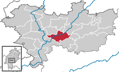
show Location of Florstadt within Wetteraukreis district | |
 Florstadt | |
| Coordinates: 50°18′57″N 8°51′47″E / 50.31583°N 8.86306°ECoordinates: 50°18′57″N 8°51′47″E / 50.31583°N 8.86306°E | |
| Country | Germany |
| State | Hesse |
| Admin. region | Darmstadt |
| District | Wetteraukreis |
| Subdivisions | 6 districts |
| Government | |
| • Mayor (2018–24) | Herbert Unger[1] (SPD) |
| Area | |
| • Total | 39.60 km2 (15.29 sq mi) |
| Elevation | 156 m (512 ft) |
| Population (2020-12-31)[2] | |
| • Total | 8,803 |
| • Density | 220/km2 (580/sq mi) |
| Time zone | UTC+01:00 (CET) |
| • Summer (DST) | UTC+02:00 (CEST) |
| Postal codes | 61197 |
| Dialling codes | 06035, 06041 (Nieder-Mockstadt) |
| Vehicle registration | FB |
| Website | www.florstadt.de |


Florstadt is a town in the Wetteraukreis, in Hesse, Germany. It is located approximately 26 kilometers (16 miles) northeast of Frankfurt am Main. It received town privileges in 2007.
Rivers[]
The river Nidda and its tributary the Horloff flow through the area of the town.
Location[]
Florstadt borders on the town Reichelsheim in the north, on Ranstadt in the northeast, on Glauburg in the east, on Altenstadt and Niddatal in the south, and on Friedberg in the west.
Districts[]
The town is divided into six districts: Leidhecken, Nieder-Florstadt, Nieder-Mockstadt, Ober-Florstadt, Staden and Stammheim.
References[]
- ^ Direkt gewählte (Ober-) Bürgermeister/-innen der hessischen Städte und Gemeinden, accessed 5 July 2021.
- ^ "Bevölkerung in Hessen am 31.12.2020 nach Gemeinden". Hessisches Statistisches Landesamt (in German). June 2021.
| show Towns and municipalities in Wetteraukreis district |
|---|
| show Authority control |
|---|
This Hesse location article is a stub. You can help Wikipedia by . |
Categories:
- Towns in Hesse
- Wetteraukreis
- Hesse geography stubs