Wetteraukreis
Wetteraukreis | |
|---|---|
 Flag 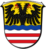 Coat of arms | |
 | |
| Country | Germany |
| State | Hesse |
| Adm. region | Darmstadt |
| Capital | Friedberg |
| Area | |
| • Total | 1,101.71 km2 (425.37 sq mi) |
| Population (31 December 2020)[1] | |
| • Total | 310,353 |
| • Density | 280/km2 (730/sq mi) |
| Time zone | UTC+01:00 (CET) |
| • Summer (DST) | UTC+02:00 (CEST) |
| Vehicle registration | FB, BÜD |
| Website | http://www.wetteraukreis.de |
The Wetteraukreis is a Kreis (district) in the middle of Hesse, Germany. Neighbouring districts are Landkreis Gießen, Vogelsbergkreis, Main-Kinzig-Kreis, district-free Stadt Frankfurt, Hochtaunuskreis and Lahn-Dill-Kreis.
History[]
The district was created in 1972 when the two districts Friedberg and Büdingen were merged.
Geography[]
The district is located between the Taunus mountains and the Vogelsberg volcanic mountain. The main rivers of the district are the Nidda River and the Wetter River.
Coat of arms[]
The imperial eagle in the top of the coat of arms was chosen because the Wetterau was imperial possession in the past. The bars in the bottom derive from the lords of Isenburg-Büdingen, who owned most of the area. The wavy line depicts the river Wetter which flows through the capital Friedberg.
Towns and municipalities[]

| Towns | Municipalities |
|---|---|
References[]
- ^ "Bevölkerung in Hessen am 31.12.2020 nach Gemeinden". Hessisches Statistisches Landesamt (in German). June 2021.
External links[]
![]() Media related to Wetteraukreis at Wikimedia Commons
Media related to Wetteraukreis at Wikimedia Commons
- Official website (in German)
Coordinates: 50°22′N 8°55′E / 50.367°N 8.917°E

| show Authority control |
|---|
- Districts of Hesse
- Wetteraukreis