Hersfeld-Rotenburg
Hersfeld-Rotenburg | |
|---|---|
 Flag 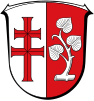 Coat of arms | |
 | |
| Country | Germany |
| State | Hesse |
| Adm. region | Kassel |
| Capital | Bad Hersfeld |
| Area | |
| • Total | 1,097.08 km2 (423.58 sq mi) |
| Population (31 December 2020)[1] | |
| • Total | 120,304 |
| • Density | 110/km2 (280/sq mi) |
| Time zone | UTC+01:00 (CET) |
| • Summer (DST) | UTC+02:00 (CEST) |
| Vehicle registration | HEF |
| Website | http://www.hef-rof.de |
Hersfeld-Rotenburg is a Kreis (district) in the east of Hesse, Germany. Neighboring districts are Werra-Meißner, Wartburgkreis, Fulda, Vogelsbergkreis, Schwalm-Eder.
History[]
In 1821 districts were created in Hesse, including the districts Hersfeld and Rotenburg, which stayed nearly unchanged (except a short period after the revolution of 1848 when they were dissolved) through the annexion of Hesse-Kassel (or Hesse-Cassel) by Prussia and the creation of the Hesse state. In 1972 both districts were merged into one.
Geography[]
The district contains the hilly landscape of Waldhessen, the mountains are of the Knüllgebirge, Stölzinger Gebirge, Richelsdorfer Gebirge and the Kuppenrhön, part of the Rhön mountains.
Coat of arms[]
The coat of arms is a combination of the two coat of arms of the precursor districts. The cross in the left half is taken from the old arms of the Hersfeld abbey; the linden branch is taken from the city arms of Rotenburg.
Towns and municipalities[]
| Towns | Municipalities | |
|---|---|---|
Twin towns[]
References[]
- ^ "Bevölkerung in Hessen am 31.12.2020 nach Gemeinden". Hessisches Statistisches Landesamt (in German). June 2021.
External links[]
| Wikimedia Commons has media related to Landkreis Hersfeld-Rotenburg. |
- Official website (in German)
- Touristic website (in German)
| hide | |
|---|---|
| Urban districts | |
| Rural districts |
|
Districts of German states (Full list)
| |
Coordinates: 50°55′N 9°45′E / 50.92°N 9.75°E

| Authority control |
|---|
- Districts of Hesse
- Hersfeld-Rotenburg