Fluchthorn
| Fluchthorn | |
|---|---|
| Piz Fenga | |
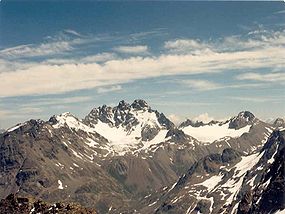 Fluchthorn from the West, July 1987 | |
| Highest point | |
| Elevation | 3,399 m (11,152 ft) |
| Prominence | 647 m (2,123 ft)[1] |
| Parent peak | Piz Linard |
| Isolation | 15.5 km (9.6 mi)[2] |
| Listing | Alpine mountains above 3000 m |
| Coordinates | 46°53′27.2″N 10°13′38.7″E / 46.890889°N 10.227417°ECoordinates: 46°53′27.2″N 10°13′38.7″E / 46.890889°N 10.227417°E |
| Geography | |
 Fluchthorn Location in the Alps | |
| Location | Tyrol, Austria Graubünden, Switzerland |
| Parent range | Silvretta Alps |
| Climbing | |
| First ascent | 1862 by Johann Jakob Weilenmann and Franz Pöll[citation needed] |
| Easiest route | Scramble |

The Fluchthorn or Piz Fenga is a mountain in the Silvretta Alps, located on the border between Austria and Switzerland. With a height of 3,399 metres (11,152 ft) above sea level, it is the second highest summit of the Silvretta Alps. The Fluchthorn lies between the Jamtal (Tyrol) and the Val Fenga (Graubünden). It consists of three summits of which the southern one is the highest.
See also[]
- List of most isolated mountains of Switzerland
- List of mountains of Graubünden
References[]
- ^ Retrieved from the Swisstopo topographic maps. The key col is the Fuorcla Zadrell (2,752 m).
- ^ Retrieved from Google Earth. The nearest point of higher elevation is north of Piz Linard.
External links[]
| Authority control |
|---|
This Tyrol location article is a stub. You can help Wikipedia by . |
This Graubünden location article is a stub. You can help Wikipedia by . |
Categories:
- Mountains of Graubünden
- Mountains of Tyrol (state)
- Mountains of the Alps
- Alpine three-thousanders
- Austria–Switzerland border
- International mountains of Europe
- Mountains of Switzerland
- Silvretta Alps
- Tyrol geography stubs
- Graubünden geography stubs