Footdee
Footdee
| |
|---|---|
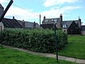
 North Square, looking towards Aberdeen harbour | |
 Footdee Location within the City of Aberdeen | |
| OS grid reference | NJ957058 |
| Council area |
|
| Lieutenancy area |
|
| Country | Scotland |
| Sovereign state | United Kingdom |
| Post town | ABERDEEN |
| Postcode district | AB11 |
| Dialling code | 01224 |
| Police | Scotland |
| Fire | Scottish |
| Ambulance | Scottish |
| UK Parliament | |
| Scottish Parliament | |
| Website | aberdeencity.gov.uk |

Footdee (Scots: Fittie) is an area of Aberdeen, Scotland known locally by its Scots language name of Fittie. It is an old fishing village at the east end of the harbour. The name is actually folk etymology. Far from being "Foot of the Dee/Fit o the Dee", it is actually a corruption of a former dedication to a "St Fittick".[1] It has also been referred to as Fort Dee.[2][3]
The area has had a settlement as far back as the Medieval times and the first recorded reference to the area of Fittie was in the year 1398. This village was slightly further North than where Footdee is now located. It would have been near to where the St Clement's Church is located.[4] The following is taken from Historic Scotland's Information Supplementary to the Statutory List:[5]
Footdee is a particularly interesting example of a planned housing development purpose-built to re-house Aberdeen's local fishing community. Laid out in 1809 by John Smith, then Superintendent Of The Town's Public Works. Smith went on to establish himself as one of Aberdeen's key architects. Occupying an isolated spit of land to the SE of Aberdeen's city centre, its regimented squares have been described as a cross between the neo-classical aspirations of Aberdeen and the close-knit fishing communities of the north-east.
The two squares of 'Fish Town' (known as Footdee), originally contained 28 single-storey thatched houses although this increased when the later Middle Row (circa 1837) and Pilot Square (circa 1855) were added. The entrances on each of the North and South squares were filled in the 1870s by William Smith (son of John and architect of Balmoral Castle). He also added additional storeys to the East and West sides of South Square creating a tenement feel. This was an attempt to ease crowding resulting from an influx of fishing families from other less prosperous areas and to help try to enforce the 'one-house-one-family' rule.
The Town Council decided to start selling the dwellings to occupiers in 1880, beginning a period of incremental development and reconstruction. Additional storeys and dormers were added piecemeal by the new owners as funds allowed. The result is one of individuality expressed within the constraints of a strictly formal plan and is a contributing factor to the special architectural and historical interest of Footdee as a whole.
Throughout the 19th century, 'tarry sheds' were added to the communal land within the squares opposite each dwelling and now every dwelling has its own shed. Originally constructed from drift wood and other found materials, the sheds have been built and rebuilt in an idiosyncratic manner over the years in a variety of materials with rendered brick now predominating slightly (2006). Some timber built sheds remain, predominantly on the North side of North Square.
North Square Mission Hall occupies the central area of the North Square, reflecting its significance as an integral part of village life. The building is plain, with simple detailing throughout, and as such, responds sympathetically to its setting and context. Known locally as 'the schoolie' the hall was built for general as well as religious purposes and continues to operate as a multi-purpose meeting space.
The entire Footdee village was added to the statutory list in 1967 as a single entity. The village was subsequently given Conservation Area status in 1968. At resurvey in 2006, each building within the Conservation Area was re-assessed separately. Key examples, demonstrating both individual architectural interest and representing the history and development of the village as a whole, were selected for listing.
On an 1828 map, the new housing squares were specifically labelled 'Fish Town'. 'Footdee' referred to the larger area from St. Clement's Church to 'Fish Town'. Later, the name 'Footdee' was used to refer specifically to the housing squares, with 'Fish Town' becoming forgotten.[6]
On Tuesday 25 September 2012, parts of Footdee became covered in foam from the sea after experiencing strong wind and rain conditions. The effect was like a blanket of snow and this made the UK national news.[7]
Gallery[]

The Church of Footdee

Nice street in Footdee
Houses and Gardens in Footdee

Footdee War Memorial


References[]
- ^ "Footdee: Overview". Gazetteer for Scotland. Retrieved 22 November 2018.
- ^ Lockhart, John Gibson (1837). Memoirs of the Life of Sir Walter Scott, Bart. Robert Cadell, Edinburgh. John Murray and Whittaker and Company, London.
- ^ "PIONEERING ENGINEERING HISTORY GEORGE FRASER & SONS PHOENIX FOUNDRY. AUCKLAND STAR". paperspast.natlib.govt.nz. 31 October 1939. Retrieved 17 August 2020.
- ^ "Footdee". aboutaberdeen.com.
- ^ "FOOTDEE, NORTH SQUARE, MISSION HALL". Historic Scotland.
- ^ "Town Plans / Views, 1580-1919". National Library of Scotland.
- ^ Strange sea foam blankets Scottish fishing village as storms batter Britain, The Telegraph.

- Areas of Aberdeen