Torry
Torry
| |
|---|---|
 Torry Location within the City of Aberdeen | |
| Population | 10,465 |
| OS grid reference | NJ952050 |
| Council area |
|
| Lieutenancy area |
|
| Country | Scotland |
| Sovereign state | United Kingdom |
| Post town | ABERDEEN |
| Postcode district | AB11 |
| Dialling code | 01224 |
| Police | Scotland |
| Fire | Scottish |
| Ambulance | Scottish |
| UK Parliament | |
| Scottish Parliament | |
| Website | aberdeencity.gov.uk |

Torry is an area within the city of Aberdeen, Scotland.
Setting and historical development[]
Torry, lying on the south bank of the River Dee, was once a Royal Burgh in its own right, having been erected a burgh of barony in 1495.[1] It was incorporated into Aberdeen in 1891, after the construction of the Victoria Bridge, itself made possible by the 1871 channelling of the River Dee which had previously followed an unstable course to the sea. The channelling also enabled further expansion of the harbour.
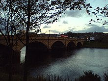
Torry is connected to the north bank of the Dee and the centre of Aberdeen by three bridges. Leading most directly to the centre of Torry, the Victoria Bridge was completed in 1887, following a ferry disaster in 1876 which claimed the lives of 32 people returning from a visit to the Bay of Nigg.[2] The bridge also has facilities for carrying water and gas services across the river. To the west of the Victoria Bridge lie the Queen Elizabeth Bridge of 1983, and the narrow Wellington Suspension Bridge. The suspension bridge was designed by Captain Samuel Brown and opened in 1831, replacing the Craiglug ferry. Refurbished in 1930, the Category A listed building was closed to vehicular traffic in 1984 and to pedestrians in March 2002. Aberdeen City Council engineers have strengthened the bridge, and have reopened it as a public footbridge.[3][4]
Land use and economy[]
Torry is famous for its fishing community and still has a number of fishing businesses operating close to the Dee. However, most of the old fishermen’s cottages of Old Torry have been swept away by first the channelling of the River Dee, then later by modern industry, particularly North Sea oil at Torry Quay.[5]
In the 1970s, 3.6 acres of land including around 100 occupied houses was cleared to make space for a Shell facility.[6][7]
Torry is also home to the Fisheries Research Laboratory in Victoria Road.
Torry has traditionally been seen as an area of low-cost housing. This has attracted students and more recently economic migrants from Eastern Europe and particularly Poland. In June 2006, a Polish shop opened on Victoria Road to cater for the influx of new workers and their families to the Aberdeen area.
The median property sale in 2004 was £34,000 compared to £91,000 in the Aberdeen City area.[8]
Unemployment in Torry is estimated at around 3 percent[9] which is high for the city. Torry is a neighbourhood highlighted as a priority area for Aberdeen’s Community Regeneration Strategy.[10] The population of Torry in 2011 was 10,465.[11]
The 18-hole Balnagask golf course offers panoramic city views from the east side of Torry, as well as a good vantage point for viewing the dolphins which frequently visit the harbour mouth area.
Garden Suburb[]
Nicholas J. Williams writes that the transfer, in 1919, of "responsibility for working-class housing from the private sector to the council" meant a vast improvement in housing quality in Aberdeen.[12] The first such houses were built at Torry, and a variety of possible plans were put on show at the Art Gallery in April, 1919. They were the work of the architects William Kelly and Harbourne McLennan and the surveyor John Gordon.[13] The following year it was announced that the building of the "initial instalment" of a proposed 500 houses was well under way. Earth from the excavated roadways around the housing development was being placed on top of the central hill summit, "and a mound, from which a complete view of the city will be obtained, is being built."[14] Ronald W. McDonald, in his history of the area, writes that the "area grew steadily between 1919 and 1933" and suggests that the "hub" of the area was the Torry Intermediate School, "opened on the 29th August 1927, with 305 pupils."[15]
Landmarks and historic buildings[]
The formerly fortified Torry Battery – last used defensively during the Second World War – is now a scheduled ancient monument, protected as a place of historical interest of national importance.[16] Close by are the remains of a rocket-propelled life-saving apparatus station (supplanted as a rescue system by the development of helicopters), and further along the shore road are a disused but preserved foghorn and Robert Stevenson-designed lighthouse.
Also of historical interest is the ruin of 's Church, built 1199, the key to which is available from the Starter's Hut near the Balnagask golf clubhouse; the graveyard has remains of many who perished in the Wreck of the Oscar (1 April 1813),[17] and a road in Torry is named Oscar Road.[18]
Balnagask Motte, near North Balnagask Road, may be the remains of the earthen mound which would have been the base of an early wooden castle, but it has never been the subject of archaeological investigation.[19]
Buildings in Torry are often used in the annual Doors Open Day event which takes place in September each year. This is a great opportunity to obtain a free viewing of interesting locales both old and new. The programme for 2006 shows Tullos Primary School and the FRS Marine Laboratory as participating.
References[]
- ^ Ó Baoill, Colm. "Saint Fittick – Some Linguistic Light?" (PDF). Clann Tuirc. Retrieved 27 April 2018.
- ^ W. Hamish Fraser and Clive H. Lee (2000). Aberdeen 1800-2000 A New History. Aberdeen: Tuckwell Press. Aberdeen City Council. ISBN 1-86232-108-6.
- ^ Frank Urquhart (30 August 2006). "175-year-old bridge to get new lease of life". The Scotsman. Edinburgh. Retrieved 30 August 2006.
- ^ "Wellington Suspension Bridge". Archived from the original on 27 September 2007. Retrieved 30 August 2006.
- ^ Smith, Robert (2004). 25 walks in and around Aberdeen. Edinburgh: Mercat Press. ISBN 1-84183-009-7.
- ^ "Tumbling Torry... and a reminder of its past". The Press and Journal. 14 February 1974. p. 7. Retrieved 12 December 2021.
- ^ "May date for Old Torry". The Press and Journal. 7 April 1972. p. 3. Retrieved 12 December 2021.
- ^ "PDF (Acrobat file) from Aberdeen City Community Planning website".
- ^ "North East Scotland Economic Research website".
- ^ "Community Planning" (PDF). Aberdeen City.
- ^ "2011 Census Neighbourhood Statistics" (PDF). Aberdeen City Council. Retrieved 4 April 2019.
- ^ Nicholas J. Williams, "Housing" in W. Hamish Fraser and Clive H. Lee (eds) Aberdeen 1800-2000 A New History Tuckewell Press, East Lothian 2000 pp. 308-310
- ^ Aberdeen Daily Journal 8 April 1919, clipping included in "Torry: From Cuttings in the Local Studies Department", Aberdeen Library Local History Collection
- ^ "Aberdeen Housing Scheme", Aberdeen Daily Journal 11 November 1920, clipping included in "Torry: From Cuttings in the Local Studies Department", Aberdeen Library Local History Collection
- ^ Ronald W. McDonald, A Short History of Torry, The Labrys Press 1995 p. 20
- ^ Historic Environment Scotland. "Torry Battery, battery 130m ESE of Old South Breakwater (SM9215)". Retrieved 12 March 2019.
- ^ "Girdleness". www.mcjazz.f2s.com. Retrieved 24 November 2020.
- ^ Board, Aberdeen Harbour. "Loss of the Whaling ship 'Oscar'". Aberdeen Harbour Board. Retrieved 24 November 2020.
- ^ The Cheerful Vale – Exploring the past of Balnagask, Tullos and Torry. Aberdeen City Council. 2006. ISBN 0-900017-66-X.
External links[]
- Book of Saint Fitticks on Electrick Scotland - History of Torry
- Conversation among Torry residents about accent, dialect and ways of life

- Areas of Aberdeen
- Royal burghs
- History of Aberdeen