Forbes County

From Wikipedia, the free encyclopedia

Map all coordinates using: OpenStreetMap 
Download coordinates as: KML
Forbes
New South Wales
Forbes NSW.PNG
Location in New South Wales
Lands administrative divisions around Forbes:
Cunningham Ashburnham Bathurst
Gipps Forbes Bathurst
Bland Monteagle King

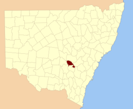
Forbes County is one of the 141 Cadastral divisions of New South Wales.

Forbes County was named in honour of Chief Justice Sir Francis Forbes (1784-1841).[1] It is located south of the Lachlan River near Forbes, down to Grenfell. It includes the area along the Lachlan east to Cowra and the Boorowa River, and also south to Koorawatha

The Lachlan River at Cowra; the river is the boundary between Forbes and Bathurst

Parishes within this county[]

A full list of parishes found within this county; their current LGA and mapping coordinates to the approximate centre of each location is as follows:

Parish LGA Coordinates
Forbes Shire 33°31′54″S 148°15′04″E / 33.53167°S 148.25111°E / -33.53167; 148.25111 (Bandon)
Cowra Shire 34°01′54″S 148°38′04″E / 34.03167°S 148.63444°E / -34.03167; 148.63444 (Bang Bang)
Weddin Shire 33°38′54″S 148°23′04″E / 33.64833°S 148.38444°E / -33.64833; 148.38444 (Binda)
Weddin Shire 33°42′54″S 148°07′04″E / 33.71500°S 148.11778°E / -33.71500; 148.11778 (Birangan)
Weddin Shire 33°48′54″S 148°05′04″E / 33.81500°S 148.08444°E / -33.81500; 148.08444 (Bogolong)
Forbes Shire 33°54′54″S 147°36′04″E / 33.91500°S 147.60111°E / -33.91500; 147.60111 (Boyd)
Forbes Shire 33°30′54″S 148°01′04″E / 33.51500°S 148.01778°E / -33.51500; 148.01778 (Braulin)
Cowra Shire 33°50′54″S 148°33′04″E / 33.84833°S 148.55111°E / -33.84833; 148.55111 (Broula)
Forbes Shire 33°30′54″S 147°53′04″E / 33.51500°S 147.88444°E / -33.51500; 147.88444 (Bundaburrah)
Cowra Shire 33°46′54″S 148°31′04″E / 33.78167°S 148.51778°E / -33.78167; 148.51778 (Conimbla)
Cowra Shire 33°54′54″S 148°46′04″E / 33.91500°S 148.76778°E / -33.91500; 148.76778 (Cudgelong)
Forbes Shire 33°25′54″S 148°08′04″E / 33.43167°S 148.13444°E / -33.43167; 148.13444 (Cumbijowa)
Forbes Shire 33°40′54″S 147°50′04″E / 33.68167°S 147.83444°E / -33.68167; 147.83444 (Currowong)
Forbes Shire 33°15′54″S 148°12′04″E / 33.26500°S 148.20111°E / -33.26500; 148.20111 (Erasa)
Weddin Shire 33°53′54″S 148°03′04″E / 33.89833°S 148.05111°E / -33.89833; 148.05111 (Eualdrie)
Gooloogong Cowra Shire 33°39′54″S 148°31′04″E / 33.66500°S 148.51778°E / -33.66500; 148.51778 (Gooloogong)
Forbes Shire 33°37′54″S 148°17′04″E / 33.63167°S 148.28444°E / -33.63167; 148.28444 (Goonigal)
Forbes Shire 33°26′54″S 147°48′04″E / 33.44833°S 147.80111°E / -33.44833; 147.80111 (Jemalong)
Weddin Shire 33°42′54″S 148°20′04″E / 33.71500°S 148.33444°E / -33.71500; 148.33444 (Kangarooby)
Forbes Shire 33°41′54″S 148°03′04″E / 33.69833°S 148.05111°E / -33.69833; 148.05111 (Maudry)
Weddin Shire 33°48′54″S 148°11′04″E / 33.81500°S 148.18444°E / -33.81500; 148.18444 (Melyra)
Cowra Shire 33°44′54″S 148°32′04″E / 33.74833°S 148.53444°E / -33.74833; 148.53444 (Merriganowry)
Cowra Shire 33°53′54″S 148°39′04″E / 33.89833°S 148.65111°E / -33.89833; 148.65111 (Morongla)
Cowra Shire 33°48′54″S 148°35′04″E / 33.81500°S 148.58444°E / -33.81500; 148.58444 (Mulyan)
Forbes Shire 33°31′54″S 148°07′04″E / 33.53167°S 148.11778°E / -33.53167; 148.11778 (Mulyandry)
Forbes Shire 33°31′54″S 148°20′04″E / 33.53167°S 148.33444°E / -33.53167; 148.33444 (Nanima)
Cowra Shire 34°01′54″S 148°43′04″E / 34.03167°S 148.71778°E / -34.03167; 148.71778 (Neila)
Forbes Shire 33°38′54″S 148°09′04″E / 33.64833°S 148.15111°E / -33.64833; 148.15111 (Ooma)
Forbes Shire 33°33′54″S 147°49′04″E / 33.56500°S 147.81778°E / -33.56500; 147.81778 (Tallabung)
Forbes Shire 33°35′54″S 148°02′04″E / 33.59833°S 148.03444°E / -33.59833; 148.03444 (Thurungle)
Forbes Shire 33°25′54″S 147°54′04″E / 33.43167°S 147.90111°E / -33.43167; 147.90111 (Waayourigong)
Weddin Shire 33°44′54″S 148°15′04″E / 33.74833°S 148.25111°E / -33.74833; 148.25111 (Wallah Wallah)
Weddin Shire 33°41′54″S 148°13′04″E / 33.69833°S 148.21778°E / -33.69833; 148.21778 (Warraderry)
Cowra Shire 33°59′54″S 148°30′04″E / 33.99833°S 148.50111°E / -33.99833; 148.50111 (Warrangong)
Cowra Shire 33°48′54″S 148°22′04″E / 33.81500°S 148.36778°E / -33.81500; 148.36778 (Warrumba)
Cowra Shire 33°54′54″S 148°37′04″E / 33.91500°S 148.61778°E / -33.91500; 148.61778 (Wattamondara)
Weddin Shire 33°45′54″S 147°56′04″E / 33.76500°S 147.93444°E / -33.76500; 147.93444 (Wheoga)
Forbes Shire 33°25′54″S 148°02′04″E / 33.43167°S 148.03444°E / -33.43167; 148.03444 (Wongajong)

References[]

  1. ^ "Forbes County". Geographical Names Register (GNR) of NSW. Geographical Names Board of New South Wales. Edit this at Wikidata
Retrieved from ""