Foresta, California
Foresta | |
|---|---|
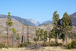 Yosemite Valley as seen from Foresta | |
 Foresta Location in California | |
| Coordinates: 37°41′54″N 119°45′19″W / 37.69833°N 119.75528°WCoordinates: 37°41′54″N 119°45′19″W / 37.69833°N 119.75528°W | |
| Country | United States |
| State | California |
| County | Mariposa County |
| Elevation | 4,314 ft (1,315 m) |

Foresta (formerly, McCauley and Opim)[2] is an unincorporated community in Mariposa County, California, within Yosemite National Park.[1] It is located 2.25 miles (3.6 km) northeast of El Portal,[2] at an elevation of 4,314 feet (1,315 m).[1] The Crane Creek census-designated place overlays the community.
The name comes from the , founded by A.B. Davis in 1913.[2] Davis built a resort at Foresta but abandoned it.[2]
The Opim post office operated there from 1882 to 1884.[2]
References[]
Municipalities and communities of Mariposa County, California, United States | ||
|---|---|---|
| CDPs |  | |
| Unincorporated communities | ||
| Former settlements | ||
| ||
This Mariposa County, California–related article is a stub. You can help Wikipedia by . |
Categories:
- Unincorporated communities in Mariposa County, California
- Populated places in the Sierra Nevada (United States)
- Yosemite National Park
- Unincorporated communities in California
- Mariposa County, California geography stubs