Foss, Oregon
Foss | |
|---|---|
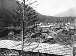 Camp Nehalem | |
 Foss Location within the state of Oregon | |
| Coordinates: 45°41′46″N 123°47′51″W / 45.69611°N 123.79750°WCoordinates: 45°41′46″N 123°47′51″W / 45.69611°N 123.79750°W | |
| Country | United States |
| State | Oregon |
| County | Tillamook |
| Elevation | 49 ft (15 m) |
| Time zone | UTC-8 (Pacific (PST)) |
| • Summer (DST) | UTC-7 (PDT) |
| Area code(s) | 503 and 971 |
| GNIS feature ID | 1120902[1] |
| Coordinates and elevation from Geographic Names Information System[1] | |


Foss is an unincorporated community in Tillamook County, Oregon, United States.[1] It is about 4 miles (6 km) east of Mohler and Oregon Route 53, near the Nehalem River.[2] Foss is the site of an important river flood gauge.[3]
Foss was named for Herbert Foss, who owned timber in the area.[4] Foss post office ran from 1928 to 1943, and Foss station on the Southern Pacific Railroad (now the Port of Tillamook Bay Railroad) was established shortly after the post office.[4] Camp Nehalem (also known as Camp Foss), a Civilian Conservation Corps (CCC) camp northeast of Foss, had a Foss mailing address.[5]
References[]
- ^ a b c "Foss". Geographic Names Information System. United States Geological Survey. November 28, 1980. Retrieved December 21, 2016.
- ^ Oregon Atlas & Gazetteer (7th ed.). Yarmouth, Maine: DeLorme. 2008. p. 20. ISBN 0-89933-347-8.
- ^ "Nehalem River Near Foss". National Weather Service Advanced Hydrologic Prediction Service. Retrieved April 1, 2012.
- ^ a b McArthur, Lewis A.; McArthur, Lewis L. (2003) [1928]. Oregon Geographic Names (7th ed.). Portland, Oregon: Oregon Historical Society Press. p. 375. ISBN 978-0875952772.
- ^ "Camp Nehalem" (PDF). Oregon Inventory of Historic Properties Historic Resource Survey Form. Oregon State Historic Preservation Office. February 1992. Retrieved April 1, 2012.
External links[]
- Foss history from VanNatta Forestry
- Image of Camp Nehalem from Oregon State University Special Collections
Municipalities and communities of Tillamook County, Oregon, United States | ||
|---|---|---|
| Cities |  | |
| CDPs | ||
| Other communities | ||
| ||
This Tillamook County, Oregon state location article is a stub. You can help Wikipedia by . |
Categories:
- Civilian Conservation Corps in Oregon
- Unincorporated communities in Tillamook County, Oregon
- 1928 establishments in Oregon
- Unincorporated communities in Oregon
- Oregon geography stubs