Fosselvi
| Fosselvi | |
|---|---|
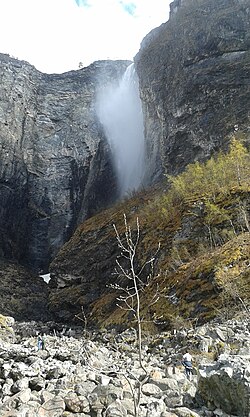 View of the river Fosselvi and Vettisfossen | |
 Location of the river | |
| Location | |
| Country | Norway |
| County | Vestland |
| Municipalities | Årdal Municipality |
| Physical characteristics | |
| Source | Vettisfossen |
| • location | Utladalen, Årdal, Norway |
| • coordinates | 61°22′45″N 07°56′51″E / 61.37917°N 7.94750°E |
| • elevation | 501 metres (1,644 ft) |
| Mouth | River |
• location | Utladalen, Årdal, Norway |
• coordinates | 61°22′56″N 07°56′19″E / 61.38222°N 7.93861°ECoordinates: 61°22′56″N 07°56′19″E / 61.38222°N 7.93861°E |
• elevation | 276 metres (906 ft) |
| Length | 473.3 m (1,553 ft) |
| Discharge | |
| • minimum | 4 m3/s (140 cu ft/s) |
| • maximum | 14 m3/s (490 cu ft/s) |


Fosselvi is a river in Årdal Municipality in Vestland county, Norway. The 473.3-metre (1,553 ft) long river starts at an elevation of 501 metres (1,644 ft) from the Vettisfossen waterfall, assuming rapids and rocks exposed above the flow surface, and reaching towards the river at an elevation of 276 metres (906 ft) in the Utladalen valley below.[1][2]
See also[]
- List of rivers in Norway
References[]
- ^ "Vettisfossen". Jotunheimen.com.
- ^ "Vettisfossen". European Waterfalls.
External links[]
 Media related to Fosselvi at Wikimedia Commons
This Vestland location article is a stub. You can help Wikipedia by . |
Categories:
- Rivers of Vestland
- Utladalen
- Vettisfossen
- Rivers of Norway
- Vestland geography stubs
- Norway river stubs