Fransum
show This article may be expanded with text translated from the corresponding article in Dutch. (February 2014) Click [show] for important translation instructions. |
Fransum | |
|---|---|
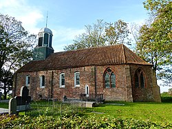 The church of Fransum | |
| Coordinates: 53°16′41″N 6°26′50″E / 53.27806°N 6.44722°E | |
| Country | Netherlands |
| Province | Groningen |
| Municipality | Westerkwartier |

Fransum (Gronings: Fraansum) is an old church village in the municipality of Westerkwartier, Netherlands. The village in the northeast of the country contains an early 13th century Romanesque church, a farm and a house.
From Den Ham a narrow road leads to the wierde, with the last part being unpaved. A dodenweg, or 'death road' runs across the wierde from north to south. From Fransum there used to be church paths to Aduard, , and Den Ham. Many of these paths disappeared later, but some have been restored as bike paths.
References[]
- Corresponding Dutch Wikipedia
- Meinema, J. (1997), Fransum: uit de geschiedenis van Fransum en zijn kerk. Onnen: 't Widde Vool. 31 p.
- IJzerman, M.J. et al. (1996), Den Ham en Fransum door de jaren heen. Bedum: Profiel. 94 p.
External links[]
 Media related to Fransum at Wikimedia Commons
| Authority control |
|
|---|
Categories:
- Geography articles needing translation from Dutch Wikipedia
- Populated places in Groningen (province)
- Westerkwartier (municipality)
- Westerkwartier