Gadara Aqueduct
hideThis article has multiple issues. Please help or discuss these issues on the talk page. (Learn how and when to remove these template messages)
|
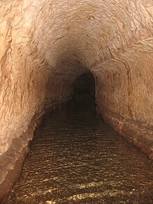
The Gadara Aqueduct, also called Qanatir Fir'awn[1] or Qanat Fir'aun (Pharaoh's Watercourse), was a Roman aqueduct supplying water for some of the cities of the Decapolis. It serviced Adraha (known today as Dera'a in Syria), Abila (at Wadi Queilebh in Jordan), and Gadara (modern-day Umm Qais in Jordan).[2] The aqueduct has the longest known tunnel of the Classical era.
There was one section of more than 106 kilometres (66 mi), constructed with qanat technology. In this special case, nearly all the shafts were diagonal at 45-60 degrees, with stairs to the real water channel inside the mountain. The line went along steep slopes and collected water from sources around the area. The first visitor who rode along the "Kanatir" was U. J. Seetzen in 1805.[citation needed]
There are gradients of 0.3 metres per mile (0.2 m/km; 1.0 ft/mi) for the tunnel section. The aqueduct starts at a Roman dam in Dilli (al-Dali, also spelled el-Dilli, Eldili, ad-Dili, c. 7 km north of the sub-district residence town of Al-Shaykh Maskin, Izra District, Daraa Governorate, Syria). From there, this part of the aqueduct line crosses several wadis via five-to-ten-metre-high (15–35 ft) bridges. During the last few decades, more than three kilometres (2 mi) of the remaining substructions were demolished on the plains between Dilli and Dera'a near the Syria-Jordan border.[citation needed]
East of Adraha was a 35-metre (115 ft) bridge. The remains of the bridge now can be found on the ground of the new located at the eastern suburbs of Dera'a. After a junction point with a side channel from the Muzayrib lake, the underground aqueduct begins. Three water systems have been found near Gadara (Umm Qais). The first and second were built with qanat technology, and the third[3] was built as a channel along a street. It is believed that all three systems were used, but each at a different period.[4]
Claims of underground city[]
Beneath the classical city of Adraha was an underground city, and was also part of the aqueduct. The inhabitants of the city collected water by jars on ropes, from the underground channel. Today, however, there is no sign of the "underground city" which was described by Wetzstein in 1860 and G. Schumacher in 1896.[citation needed]
See also[]
- Decapolis
- List of aqueducts in the Roman Empire
- List of Roman aqueducts by date
- Ancient Roman technology
- Roman engineering
References[]
- ^ van Donzel, Emeri Johannes (1994). Islamic Desk Reference. BRILL. p. 24. ISBN 9789004097384. Retrieved 10 July 2020.
- ^ Döring, Mathias; Radler, Siegfried (2015), "Stau- und Wasserkraftanlagen", Taschenbuch der Wasserwirtschaft, Springer Fachmedien Wiesbaden, pp. 637–721, doi:10.1007/978-3-8348-8216-5_11, ISBN 9783528125806
- ^ Döring, Mathias "Qanat Fir'un - Documentation of the 100 Kilometres Aqueduct Tunnel in Northern Jordan. Annual of the Department of Antiquities of Jordan, Amman, Jordan 2009, pp. 153–165.
- ^ "Qanat Fir'aun / Dekapolis Aquädukt | Qanat Fir'aun". www.dekapolis-aquaedukt.de (in German). Retrieved 2018-10-25.
Bibliography[]
- Döring, Mathias, "Qanat Firaun. 106 km langer unterirdischer Aquädukt im nordjordanischen Bergland, Schriften der Deutschen Wasserhistorischen Gesellschaft, Vol. 10 (2008), pp. 1–16
- Döring, Mathias, "Wasser für die Dekapolis - Jordanisches Bergland birgt längsten bisher bekannten Aquädukttunnel. Ein Zwischenbericht. Deutsches Archäologisches Institut, Forschungs Cluster 2, Berlin 2012, 225-243.
- Döring, Mathias, "Wasser für die Dekapolis. Römische Fernwasserleitung in Syrien und Jordanien. Deutsche Wasserhistorische Gesellschaft Vol. S 12, 2016, pp. 1–248, ISBN 978-3-9815362-3-2.
- Döring, Mathias, "Roman Water Systems in Northern Jordan", Proceedings of the 12th International Congress on the History of Water Management and Hydraulic Engineering in the Mediterranean Region (Ephesus, Oct. 2004), Österreichisches Archäologisches Institut, Sonderschriften, Vol. 42 (Leuven, 2006), pp. 237–243
External links[]
- Rome's tremendous tunnel. The Ancient World's Longest Underground Aqueduct, Spiegel Online
- [1], Qanat Fir'aun, the more than 150 km long Decapolis Aqueduct in Syria and Jordan, Jens Kleb
International
- Gadara (Jordan), romanaqueducts.info


- Persian developed underground aqueducts
- Buildings and structures completed in the 2nd century
- Aqueducts in Jordan
- Roman aqueducts outside Rome
- Archaeological sites in Jordan
- Roman sites in Jordan
- Ancient Greek archaeological sites in Western Asia
- Ancient history of Jordan
- Hellenistic sites