Aqua Claudia


Aqua Claudia ("the Claudian water") was an ancient Roman aqueduct that, like the Aqua Anio Novus, was begun by Emperor Caligula (37 – 41 AD) in 38 AD and finished by Emperor Claudius (41 – 54 AD) in 52 AD.[1]
Together with Aqua Anio Novus, Aqua Anio Vetus, and Aqua Marcia, it is regarded as one of the "four great aqueducts of Rome".[2]
Route[]

Its mainsprings, the Caeruleus and Curtius, were situated 300 paces to the left of the 38th milestone of the Via Sublacensis.[3]
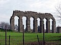
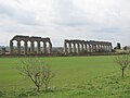
The total length was approximately 69 kilometres (43 mi), most of which was underground. The flow was about 190,000 cubic metres (6,700,000 cu ft) in 24 hours (about 2.3 cubic metres per second (80 cu ft/s)).[4] Directly after its filtering tank, near the seventh mile of the Via Latina, it finally emerged onto arches, which increase in height as the ground falls toward the city, reaching over 30 metres (100 ft).
It is one of the two ancient aqueducts that flowed through the Porta Maggiore, the other being the Anio Novus. It is described in some detail by Frontinus in his work published in the later 1st century, De aquaeductu.
Nero extended the aqueduct with the Arcus Neroniani to the Caelian hill and Domitian further extended it to the Palatine[5] after which the Aqua Claudia could provide all 14 Roman districts with water.[6] The section on the Caelian hilll was called arcus Caelimontani.
Repairs[]
The aqueduct went through at least two major repairs. Tacitus suggests that the aqueduct was in use by AD 47.[7] An inscription from Vespasian suggests that Aqua Claudia was used for ten years, then failed and was out of use for nine years.[8] The first repair was done by Emperor Vespasian in 71 AD; it was repaired again in 81 AD by Emperor Titus.[9]
Alexander Severus reinforced the arches of Nero (CIL VI.1259) where they are called arcus Caelimontani, including the line of arches across the valley between the Caelian and the Palatine.
The church of San Tommaso in Formis was later built into the side of the aqueduct.
Gallery[]


The Arcus Nerioniani near the Caelian and the Palatine Hills.


See also[]
- Ancient Roman technology
- List of aqueducts in the city of Rome
- List of aqueducts in the Roman Empire
- List of Roman aqueducts by date
- Parco degli Acquedotti
- Roman engineering
- Roman technology
Notes[]
- ^ Frontinus. De aquaeductu. 1.13.
- ^ Blackman, Deane R. (1978). "The Volume of Water Delivered by the Four Great Aqueducts of Rome". Papers of the British School at Rome. 46: 52–72. doi:10.1017/S0068246200011417. JSTOR 40310747.
- ^ Dembskey, E.J. (2009). "Aqua Claudia". Roman Aqueducts. Retrieved 28 May 2018.
- ^ Schram, Wilke D. (January 2010). "Aqua Claudia". Roman Aqueducts. Retrieved 15 March 2013.
- ^ "The Aqueducts". Maquettes Historiques. Archived from the original on 4 December 2017. Retrieved 28 May 2018.
- ^ Platner, Samuel Ball (1929). "Arcus Neroniani". In Ashby, Thomas (ed.). A Topographical Dictionary of Ancient Rome. London: Oxford University Press. pp. 40–41.
- ^ Georges, K. E. (1874-01-01). "Tac. Ann. 11, 23". Philologus. 33 (1–4). doi:10.1524/phil.1874.33.14.311. ISSN 2196-7008.
- ^ Christol, Michel (1981). "Doubles lyonnais d'inscriptions romaines de Narbonne (CIL, XIII, 1994 = CIL, XII, 4486 ; CIL, XIII, 1982 a = CIL, XII, 4497)". Revue archéologique de Narbonnaise. 14 (1): 221–224. doi:10.3406/ran.1981.1068. ISSN 0557-7705.
- ^ "Gale, Baroness, (Anita Gale) (born 28 Nov. 1940)", Who's Who, Oxford University Press, 2007-12-01, doi:10.1093/ww/9780199540884.013.u16642
External links[]
| Wikimedia Commons has media related to Aqua Claudia. |
- Interactive map with the full Aqua Claudia
- Map of Rome with Aqua Claudia running (red)
- The Aqua Claudia Webpage
- 3D digital model of Rome featuring Aqua Claudia

| Authority control |
|
|---|

- Buildings and structures completed in the 1st century
- Classical aqueducts in Rome
- 50s establishments in the Roman Empire
- 1st-century establishments in Italy
- Claudius
- Caligula
- 52 establishments