Gadfa
This article needs additional citations for verification. (October 2019) |
| Gadfa | |
|---|---|
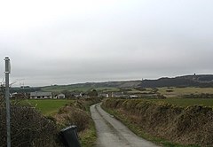 An access road that runs west from the A5025 to Penterfyn-Gadfa. | |
 Gadfa Location within Anglesey | |
| OS grid reference | SH 4607 8985 |
| • Cardiff | 140 mi (230 km) |
| • London | 218.8 mi (352.1 km) |
| Community | |
| Principal area | |
| Country | Wales |
| Sovereign state | United Kingdom |
| Post town | Penysarn |
| Police | North Wales |
| Fire | North Wales |
| Ambulance | Welsh |
| UK Parliament | |
| Senedd Cymru – Welsh Parliament | |

Gadfa is a hamlet in the community of Llaneilian, Ynys Môn, Wales, which is 140 miles (225.3 km) from Cardiff and 218.8 miles (352.1 km) from London.
The dispersed settlement has a scatter of buildings mainly along and to the west of the A5025, with a smaller number on the eastern side of the road.[1]
See also[]
Map of Llaneilian Community, showing Gadfa and the surrounding area.[1]
References[]
- ^ a b historicwales.gov.uk the map enabled portal for historic environment in Llaneilian. Accessed 15 November 2017
| Towns |  | |
|---|---|---|
| Villages |
| |
| Hydrological features | ||
| Ancient sites | ||
| Islands | ||
| Topics |
| |
This Anglesey location article is a stub. You can help Wikipedia by . |
Categories:
- Villages in Anglesey
- Anglesey geography stubs