Gahcho Kue Aerodrome
Gahcho Kue Aerodrome | |||||||||||
|---|---|---|---|---|---|---|---|---|---|---|---|
| Summary | |||||||||||
| Airport type | Private | ||||||||||
| Owner/Operator | De Beers Canada | ||||||||||
| Serves | Gahcho Kue Diamond Mine Project | ||||||||||
| Location | |||||||||||
| Time zone | MST (UTC−07:00) | ||||||||||
| • Summer (DST) | MDT (UTC−06:00) | ||||||||||
| Elevation AMSL | 1,429 ft / 436 m | ||||||||||
| Coordinates | 63°26′07″N 109°08′41″W / 63.43528°N 109.14472°WCoordinates: 63°26′07″N 109°08′41″W / 63.43528°N 109.14472°W | ||||||||||
| Map | |||||||||||
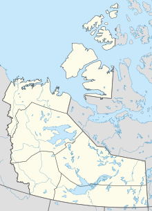
 GHK Location in the Northwest Territories | |||||||||||
| Runways | |||||||||||
| |||||||||||
Source: Canada Flight Supplement[1] | |||||||||||
Gahcho Kue Aerodrome (IATA: GHK, TC LID: CGK2) is an airport located 1.4 nautical miles (2.6 km; 1.6 mi) east southeast of the Gahcho Kue Diamond Mine Project, Northwest Territories, Canada. The airport is owned and operated by De Beers Canada and serves the Gahcho Kue Diamond Mine Project. The airport originally was an ice runway on and was 5,146 ft (1,569 m) in length and numbered 08/26. The ice runway was only open from January to April.
References[]
Categories:
- Registered aerodromes in the North Slave Region
- De Beers
- Northwest Territories airport stubs