Galdames
Galdames | |
|---|---|
 View from Serantes | |
 Coat of arms | |
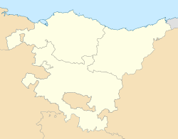 Galdames Location of Galdames within the Basque Country | |
| Coordinates: 43°15′18″N 3°5′47″W / 43.25500°N 3.09639°WCoordinates: 43°15′18″N 3°5′47″W / 43.25500°N 3.09639°W | |
| Country | Spain |
| Autonomous community | Basque Country |
| Province | Biscay |
| Comarca | Enkarterri |
| Government | |
| • Alcalde | Carlos Avellanal Villanueva (EAJ-PNV) |
| Area | |
| • Total | 44.36 km2 (17.13 sq mi) |
| Elevation | 166 m (545 ft) |
| Population (2018)[1] | |
| • Total | 829 |
| • Density | 19/km2 (48/sq mi) |
| Demonym(s) | galdamestarra |
| Time zone | UTC+1 (CET) |
| • Summer (DST) | UTC+2 (CEST) |
| Postal code | 48191 |
| Official language(s) | Basque, Spanish |
| Website | Official website |

show This article may be expanded with text translated from the corresponding article in Basque. (June 2010) Click [show] for important translation instructions. |
Galdames (Basque pronunciation: [ɡaldames̺]) is a valley, town and municipality located in the province of Biscay, in the autonomous community of Basque Country, northern Spain.
Main sights are Santa Maria Magdalena and Arenaza caves, both situated in Triano mountain range and the latter containing stalactites and rest of mining operations. Medieval Tower of Loizaga is located in Concejuelo ward, nowadays site of a museum of classic automobiles.[2]
Neighborhoods[]
Galdames is administratively divided into 8 neighborhoods or wards:[3]
- Atxuriaga (La Aceña).
- Concejuelo.
- Humaran.
- Larrea.
- Montellano.
- San Esteban Galdames.
- San Pedro Galdames.
- Txabarri.
Demography[]
| 1897 | 1900 | 1910 | 1920 | 1930 | 1940 | 1950 | 1960 | 1970 | 1981 | 1991 | 2001 | 2006 |
|---|---|---|---|---|---|---|---|---|---|---|---|---|
| 2,310 | 2,886 | 3,856 | 3,854 | 3,335 | 3,022 | 2,312 | 1,892 | 1,249 | 812 | 799 | 799 | 813 |
References[]
- ^ Municipal Register of Spain 2018. National Statistics Institute.
- ^ Ainhoa Arozamena & Manu Castaño. "Auñamendi Encyclopedia: Galdames" (in Spanish). . Retrieved 27 June 2010.
- ^ Euskaltzaindia. "Euskal Onomastikaren Datutegia (EODA): Galdames" (in Basque). Euskaltzaindia. Retrieved 27 June 2010.

| show Authority control |
|---|
This article about a location in the Basque Country, Spain, is a stub. You can help Wikipedia by . |
Categories:
- Municipalities in Biscay
- Basque geography stubs