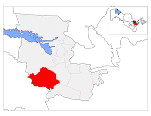
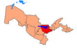
Gallaorol District
Coordinates: 39°59′18″N 67°35′02″E / 39.9882°N 67.5840°E

Gallaorol | |
|---|---|
| G`allaorol tumani | |
 | |
| Country | Uzbekistan |
| Region | Jizzakh Region |
| Capital | Gallaorol |
| Established | 1926 |
| Area | |
| • Total | 1,950 km2 (750 sq mi) |
| Population | |
| • Total | 127 500 |
| Time zone | UTC+5 (UZT) |
G'allaorol is a raion (district) of about 2,000 km2 in Jizzakh Region, Uzbekistan. The capital lies at Gallaorol.
Settlements[]
There are one city (G'allaorol), 2 towns (Mar-jonbuloq, Qoʻytosh) and 11 villages (Buloqboshi, Guliston, Ittifoq, Koʻkbuloq, Madaniyat, Mirzabuloq, Moʻltob, Mulkush, Tozaurugʻ, Qipchoqsoy, Gʻoʻbdin).
Population[]
It has a population of 127,500 people, mainly Uzbeks, but also Russians, Tatars and of other nationalities. The average density of the population is 19 people per km2. The urban population is 32.2 thousand, the rural population is 91.6 thousand people.
Geography[]
Topography[]
The central and western part of the G'allaorol district is composed of plains, with high mountain ranges and mountains. The district is surrounded by Nurata Range from the north and the Molguzar Mountain in the east.
Geology[]
The most parts of the Gallyarol region is formed by plains consisting of loess and yellow soil layer, moving from 380 to 400 meters to the north of 1600-1900 meters to the north. This plain, formed by the Sangzor River, dates back to the Nurata mountain range. The soil in the central and northern part of the hillsides is a greasy, opaque, typical gray soils formed on the soil. The territory of the district is rich in mineral resources such as lead minerals, zircon, zinc and gold. There are sand, gravel, gypsum, granite, limestone and other homogeneous construction materials of local significance. The district also profits from mineral water supply.
Climate[]
Climate is sharp continental, dry summer, cold winter. The average January temperature is -2 ° C and 32 ° C in July. Yearly rainfall is 326 mm. Vegetation period is 240 days.
Economy[]
In the community and private farms of the district have cattle, sheep and goats, poultry and parrots. There is also a production of cereals, vegetables, potatoes, melons and vine.
Wildlife[]
The wild-growing plants are tulips, lilac, mulberry, sesame, shoreta, wormwood, spruce, bergamot, among others. The fauna consists of wolves, foxes, hogs, alleys, arches, rabbits; rodents, frogs, poisonous snakes, echinaceae, hawthorn, the moth, the mushroom, the field mouse; eagles, birds, quails, shrubs, doves, pigeons, there are various fishes in the water basins. Some kinds of mushroom also exist.[1]
History[]
There are several archeological sites dating back until the first century (BC), called Qoʻngʻirtepa, Shaxidtepa, Almantepa, Jalmantepa, Lapaktepa, Pardakultepa, Nushkent.
Established on September 29, 1926, it was called Yangiqoʻrgʻon district until 1931.
References[]
- ^ OʻzME. Birinchi jild. Tashkent. 2000.
Capital: Jizzakh | ||
|  | |
This Uzbekistan location article is a stub. You can help Wikipedia by . |
- Uzbekistan geography stubs
- Districts of Uzbekistan
- Jizzakh Region