Gambia River
| Gambia River | |
|---|---|
 Gambia River in the Niokolo-Koba National Park | |
 Map of the Gambia River drainage basin | |
| Location | |
| Countries | |
| Physical characteristics | |
| Source | Fouta Djallon |
| Mouth | Atlantic Ocean |
• location | Banjul |
• coordinates | 13°28′N 16°34′W / 13.467°N 16.567°WCoordinates: 13°28′N 16°34′W / 13.467°N 16.567°W |
| Length | 1,120[1] km (700 mi) |

The Gambia River (formerly known as the River Gambra) is a major river in West Africa, running 1,120 kilometres (700 mi) from the Fouta Djallon plateau in north Guinea westward through Senegal and The Gambia to the Atlantic Ocean at the city of Banjul. It is navigable for about half that length.
The river is strongly associated with The Gambia, the smallest country in mainland Africa, which consists of little more than the downstream half of the river and its two banks.
Geography[]
From the Fouta Djallon, the river runs northwest into the Tambacounda Region of Senegal, where it flows through the Parc National du Niokolo Koba, then is joined by the and before entering the Gambia at Fatoto. At this point, the river runs generally west, but in a meandering course with a number of oxbows, and about 100km from its mouth it gradually widens, to over 10km wide where it meets the sea.
Crossings[]
As of 2020, there is only one fixed-link crossing of the river, the Senegambia Bridge near the towns of Farafenni and Soma in The Gambia. Opened in January 2019, it provides a link between the stretches of the Trans-Gambia Highway on the North and South Bank of the river. It also provides an expedited connection for Senegalese trucks traveling to and from Casamance. The bridge is 1.9 kilometers long and replaces a previously-unreliable vehicle ferry. A toll is levied on vehicle crossings.
All other crossings within the Gambia are done by ferry, including a primary crossing between Banjul and Barra at the mouth of the river.
History[]
Near the mouth of the river, near Juffure, is Kunta Kinteh Island, a place used in the slave trade which is now a UNESCO World Heritage Site. The Duke of Courland established fort St. Andrea where he purchased slaves and sold English goods, but in February 1660 he reportedly sold the place to the Dutch.[2]
Flora and fauna[]
The aquatic fauna in the Gambia River basin is closely associated with that of the Senegal River basin, and the two are usually combined under a single ecoregion known as the Senegal-Gambia Catchments. Although the species richness is moderately high, only three species of frogs and one fish are endemic to this ecoregion.[3]
Oysters are harvested from the River Gambia by women and used to make oyster stew, a traditional dish in the cuisine of Gambia.
Photo gallery[]
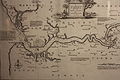
Map of the River Gambra (now the Gambia) 1732
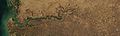
The western portion of the Gambia River, seen from space. The line shows the border of The Gambia.

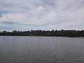
Upstream view of the river, near Janjanbureh Island
Bank of the river, near Janjanbureh
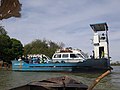
Ferry crossing of the river, at Janjanbureh


References[]
- ^ "Gambia River". Encyclopædia Britannica. Retrieved 30 October 2016.
- ^ "America and West Indies: May 1673." Calendar of State Papers Colonial, America and West Indies: Volume 7, 1669-1674. Ed. W Noel Sainsbury. London: Her Majesty's Stationery Office, 1889. 487-499. British History Online Retrieved 17 March 2021.
- ^ "509: Senegal – Gambia". Freshwater Ecoregions of the World. Archived from the original on 30 October 2016. Retrieved 30 October 2016.
External links[]
 Media related to Gambia River at Wikimedia Commons
- Gambia River Information & Photos
| hide Authority control | |
|---|---|
| General | |
| National libraries | |
- Gambia River
- Rivers of Guinea
- Rivers of the Gambia
- Rivers of Senegal
- International rivers of Africa
- Banjul