Garni
Garni Գառնի | |
|---|---|
 Garni as seen from the Shrine of Saint Sargis | |
 Garni Գառնի | |
| Coordinates: 40°07′10″N 44°43′23″E / 40.11944°N 44.72306°ECoordinates: 40°07′10″N 44°43′23″E / 40.11944°N 44.72306°E | |
| Country | |
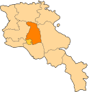
| Marz | Kotayk |
| Government | |
| • Mayor | Aharon Sahakyan |
| Area | |
| • Total | 33.42 km2 (12.90 sq mi) |
| Elevation | 1,400 m (4,600 ft) |
| Population (2011 census) | |
| • Total | 6,910 |
| • Density | 210/km2 (540/sq mi) |
| Time zone | GMT +4 |

Garni (Armenian: Գառնի), is a major village in the Kotayk Province of Armenia. It is known for the nearby classical temple. As of the 2011 census, the population of the village is 6,910.[1]
History[]
The settlement has an ancient history, and is best known for the Hellenistic Garni temple. The area was first occupied in the 3rd millennium BC along easily defensible terrain at one of the bends of the Azat River. In the 8th century BC the area was conquered by the Urartian King Argishti Iin a war against Diauehi.[2] An early Georgian formation that co-existed alongside with Urartu. The fortification at Garni was erected probably sometime in the 3rd century BC as a summer residence for the Armenian Orontid and Artaxiad royal dynasties. Later around the 1st century AD the fortress of Garni became the last refuge of King Mithridates of Armenia and where he and his family were assassinated by his son-in-law and nephew Rhadamistus. The fortress was eventually sacked in 1386 by Timur Lenk. In 1679 an earthquake devastated the area destroying the temple.
Monuments and landmarks[]
Garni is notable for its fortress complex with the 1st-century AD Garni Temple, , Mashtots Hayrapet Church, a ruined 4th-century single-aisle church, a ruined Tukh Manuk Shrine, Saint Sargis Shrine, and a Queen Katranide Shrine.
Nearby is the Garni Gorge with well preserved basalt columns, carved out by the Goght River. This portion of the gorge is typically referred to as the "Symphony of the Stones". It is most easily reached via a road that leads left down the gorge just before reaching the temple of Garni. Another road leads to the gorge through the village, down a cobblestone road, and into the valley.
Once in the valley, turning right will lead to Garni Gorge, an 11th-century medieval bridge, and the "Symphony of the Stones". Taking a left will lead along the river past a fish hatchery, up to the Khosrov State Reserve, and a little further Havuts Tar Monastery (which may be seen from the temple). The medieval bridge was controversially restored in 2013, in a project organized and paid for by the US government through its Ambassadors Fund for Cultural Preservation.[3] Critics said the work destroyed the bridge's value as an historical monument.[4] Within the Khosrov reserve is Aghjots Vank from the 13th century, the church of Saint Stepanos, and the fortress of Kakavaberd. Garni lies along the road to the UNESCO World Heritage Site of Geghard Monastery (a further 7 km southeast).
Gallery[]
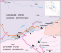
Map of Garni and the surrounding area
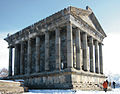
Garni Temple
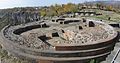
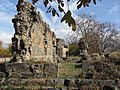
Saint Sion Church foundations adjacent to Garni Temple, 7th to 9th centuries

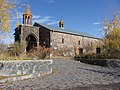
Mashtots Hayrapet Church, 12th century
Garni, Surp Astvatsatsin Church, 11th century[citation needed]
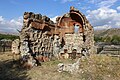
Khumarazham Church ruins, 4th-5th centuries
Ruins of a 4th-century[citation needed] single-aisle chapel at the west side of the Garni cemetery

Garni Gorge "Symphony of the Stones"

11th-century bridge crossing the Azat River in Garni Gorge (prior to reconstruction)

The Havuts Tar Monastic Complex located across the gorge from Garni, 11th-13th centuries

Aghjots Vank of the 13th century located within the Khosrov State Reserve


See also[]
References[]
- ^ "Kotayk population" (PDF).
- ^ Melkʻonyan, A. A. (2007). Javakhk in the 19th century and the 1st quarter of the 20th century : a historical research. Erevan: National Academy of Sciences of the Republic of Armenia, Institute of History. ISBN 978-99941-73-07-5. OCLC 607636080.
- ^ "Medieval bridge of Garni will be put in operation in autumn".
- ^ "Armenia protest: Activists call for attention to Garni bridge". www.tert.am.
External links[]
| Wikivoyage has a travel guide for Garni. |
| Wikimedia Commons has media related to Garni. |
- Armeniapedia.org: Garni Village
- Surb Astvatsatsin Church (17th-19th centuries), Garni: photo1, photo2
- Khumarzham (Khonarvats) Church (4th-5th centuries) ruins, Garni: photo1, photo2
- Old Khachkars (Cross-stones), Garni: photo1, photo2, photo3, photo4, photo5
- Surb Astvatsatsin Church (12th century) ruins, Garni: photo1, photo2
- Cave-Fort, Garni
| show Authority control |
|---|
- Populated places in Kotayk Province
- Tourist attractions in Kotayk Province
- Erivan Governorate