Garoth
Garoth | |
|---|---|
| गरोठ | |
 Garoth Location in Madhya Pradesh, India | |
| Coordinates: 24°19′29″N 75°39′7″E / 24.32472°N 75.65194°ECoordinates: 24°19′29″N 75°39′7″E / 24.32472°N 75.65194°E | |
| Country | |
| State | Madhya Pradesh |
| District | Mandsaur |
| Area | |
| • Total | 120 km2 (50 sq mi) |
| Population (2012) | |
| • Total | 15,122 |
| • Density | 130/km2 (330/sq mi) |
| Languages | |
| • Official | Hindi |
| Time zone | UTC+5:30 (IST) |
| PIN | 458880 |
| Telephone code | 07425 |
| Vehicle registration | M.P-14 |
| Sex ratio | 51% Male 49% Female ♂/♀ |
| Literacy | 87.38%[1]% |

Garoth is a town in the Malwa region of Madhya Pradesh state in central India. It is one of the tehsil of Mandsaur District.It shares boundary with Jhalawar district of Rajasthan.
Demographics[]
The town has an area of 9,791 km2. The district is part of the Malwa region, and is bounded by Neemuch District to the north, Rajasthan state to the east and west and It is part of Ujjain Division
Garoth forms the northern projection of Madhya Pradesh from its western Division, i.e., Ujjain Commissioner's Division
As of 2012 India census,[2] Garoth had a population of 1,89,729. Males constitute 51% of the population and females 49%. Garoth has an average literacy rate of 63%, higher than the national average of 59.5%: male literacy is 76%, and female literacy is 50%. In Garoth, 15% of the population is under 6 years of age.
Gandhi Sagar dam[]
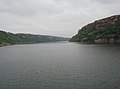
Gandhisagar Dam is situated at a distance of 60 km. from the city headquarter. The Dam is constructed on the Chambal River.
References[]
- ^ "Literacy rate". Web.archive.org. 16 June 2004. Retrieved 29 April 2012.
- ^ "Census of India 2001: Data from the 2001 Census, including cities, villages and towns (Provisional)". Census Commission of India. Archived from the original on 16 June 2004. Retrieved 1 November 2008.
- Cities and towns in Mandsaur district