Shajapur
hideThis article has multiple issues. Please help or discuss these issues on the talk page. (Learn how and when to remove these template messages)
|
Shajapur | |
|---|---|
Town | |
 Map showing Shajapur in Madhya Pradesh, India | |
| Coordinates: 23°26′N 76°16′E / 23.43°N 76.27°E | |
| Country | |
| State | Madhya Pradesh |
| District | Shajapur |


Shajapur is a town in Malwa region of Madhya Pradesh state in west-central India. It is the headquarters of Shajapur district.
History[]
Shajapur is named after Shahjahan, the Mughal Emperor who halted here in 1640. It is said that the original name was Shahjahanpur, which colloquially reduced to Shajapur. When Gwalior acceded to the Government of India after Indian Independence in 1947, Shajapur district, along with the rest of Gwalior state, became part of Madhya Bharat. Madhya Bharat was merged into Madhya Pradesh on 1 November 1956
Geography[]
Shajapur is located at 23°26′N 76°16′E / 23.43°N 76.27°E.[1] It has an average elevation of 443 m (1,453 ft). The highest peak is known as Bhairo Dungri.

Climate[]
| hideClimate data for Shajapur (1981–2010, extremes 1969–2012) | |||||||||||||
|---|---|---|---|---|---|---|---|---|---|---|---|---|---|
| Month | Jan | Feb | Mar | Apr | May | Jun | Jul | Aug | Sep | Oct | Nov | Dec | Year |
| Record high °C (°F) | 33.6 (92.5) |
38.3 (100.9) |
42.1 (107.8) |
45.6 (114.1) |
47.2 (117.0) |
46.1 (115.0) |
40.7 (105.3) |
39.1 (102.4) |
39.8 (103.6) |
39.0 (102.2) |
36.1 (97.0) |
32.7 (90.9) |
47.2 (117.0) |
| Average high °C (°F) | 26.1 (79.0) |
29.1 (84.4) |
34.6 (94.3) |
39.3 (102.7) |
41.4 (106.5) |
38.1 (100.6) |
32.0 (89.6) |
29.7 (85.5) |
32.0 (89.6) |
33.6 (92.5) |
30.5 (86.9) |
27.3 (81.1) |
32.8 (91.0) |
| Average low °C (°F) | 8.8 (47.8) |
10.7 (51.3) |
15.7 (60.3) |
21.6 (70.9) |
26.2 (79.2) |
25.8 (78.4) |
23.9 (75.0) |
23.1 (73.6) |
22.2 (72.0) |
17.8 (64.0) |
12.4 (54.3) |
9.2 (48.6) |
18.1 (64.6) |
| Record low °C (°F) | −0.5 (31.1) |
1.5 (34.7) |
5.1 (41.2) |
9.3 (48.7) |
17.8 (64.0) |
20.3 (68.5) |
19.6 (67.3) |
20.0 (68.0) |
12.1 (53.8) |
9.5 (49.1) |
3.3 (37.9) |
2.1 (35.8) |
−0.5 (31.1) |
| Average rainfall mm (inches) | 8.0 (0.31) |
4.2 (0.17) |
1.6 (0.06) |
3.0 (0.12) |
11.4 (0.45) |
95.1 (3.74) |
239.4 (9.43) |
318.3 (12.53) |
126.8 (4.99) |
24.9 (0.98) |
10.6 (0.42) |
4.5 (0.18) |
847.7 (33.37) |
| Average rainy days | 0.6 | 0.3 | 0.3 | 0.5 | 1.1 | 4.8 | 9.3 | 10.6 | 6.0 | 1.6 | 0.7 | 0.4 | 36.3 |
| Average relative humidity (%) (at 17:30 IST) | 43 | 33 | 24 | 18 | 22 | 43 | 67 | 76 | 65 | 43 | 43 | 46 | 43 |
| Source: India Meteorological Department[2][3] | |||||||||||||
Demographics[]
As of 2011 India census,[4] Shajapur district had a population of 1,290,685, with 669,852 males and 620,833 females.
The most common language spoken is Hindi, but people still speak Malvi, a local language similar to Hindi in dialect and script.
Tourism[]
The town contains numerous places of interest including:
- Astana Aliya Warsiya of Waris Ali Shah (The great sufi saint) at Dayra.
- Sonaniya Bheru Maharaj temple is situated in Araniya Kalan (town in Kalapipal block).
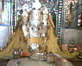
- The Raj Rajeshwari Temple is one of the famous Shakti Temple. Sculpture of temple is about 10th century A.D. Age of Parmars. It is situated near the A.B, Road. It is estimated to have been built between 1007 and 1009 by Raja Bhoj. Mangal Nath Temple is behind the Raj Rajeshvari Temple and near the Bank of Chillar River.
- The Karedi Mata temple, which was built by Karan (Mahabharata)(15 km From District HQ situated In Ujjain-Shajapur District Boundaries) "Mahakaleswar Temple" is situated in "sundersi". It was from ancient times. Sundersi is a historical place in the honor of 'sunderbai' sister of "maharaja Vikramaditya" this place is known as "Sundergarh".
- The old fort is near the bank of the Chiler river built by the Mughal Emperor. The fort used to contain the district court but it is now home of the Girls District College (GDC).
- Pale wale Baba ka Mandir (Khardon Kalan) & Mata Vijyasan Mandir (Lasudliya Patla) are at 110 km from Shajapur.
- Pandu Kho (Near Lal Ghati) where Pandavas (Mahabharat) stayed during their Vanvas.
- Bapu Ki Kutia is situated near collectorate at AB Road, Shajapur (Temple & Samadhi).
- Muradpura Temple (old Famous Temple of God Hanuman)
- Mankamneshwar Mahadev Temple (Kumharia Khas) is a very old Temple of God Shiva.
- Baba Baijnath Temple (Agar) is 70 km from district headquarters.
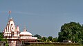
- Mata Baglamukhi Temple (Nalkheda) is one of the shakti peeth in India and a very famous temple of Nalkheda tehsil (now in the newly made district).
- Nityanand Ashram is situated at AB Road Shajapur
- Bhairo Dungri is the highest mountain peak in Shajapur and having a temple at the top.
- Fort and Jama Masjid.
- Mazare-e-sherif, the famous mazare is situated near at Kashinagar, Shajapur.
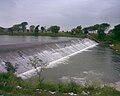
- Chillar Dam is a very important tourist place. It is the lifeline of shajapur.[citation needed] It is situated in the village of Sanpkheda.
- Iklera Mataji is the famous temple situated at Iklera.
- Ballon is the famous temple situated at Ballon pond.
- Famous temple of God Hanuman is situated at Bolai.
- Famous temple of Baba Ramdev Ji Maharaj is situated at Khatsur.
- Famous temple of Ilahi Mata Ji is situated at Village Madana.
- Famous Kamdhenu Gau-Shaala is situated at Village Madana, which is having more than 200 cows.[citation needed]
- Gayatri Mandir (Temple of Goddess Gayatri)is situated near Station Road, Rajnagar Colony.
- Dargah e Yusufi - Famous Dawoodi Bohra Pilgrimage.
- Shri Hatkeshwar Dham ( Mahankal Mandir)- Famous place situated at village Semli. Where cow shelter is also there having more than 200 cows. And also famous Katha Vachak Sant Kamal Kishor Ji Nagar.
- Gopal Mandir of Village Kanheriya Khedi.And the uniqueness due to wall around the village has 3 gates and 2 windows.
[5][6]
Gallery[]

Raj Rajeshwari Temple
Mata Baglamukhi Temple
Chillar Dam

Pandu Kho

Muradpura Hanuman Temple
Gopal Mandir of Village Kanheriya Khedi

Picnic spot near village Kanheriya Khedi.
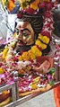
Mahakal sawari of Village Ranthbhanwar.


In popular media[]
In the opening scenes of the popular yesteryears Hindi film, Shree 420, the protagonist (Raj Kapoor) finds a road crossing showing the direction to three places, of which one is Shajapur. The other two are Dewas and Bombay.[7]
References[]

- ^ "Falling Rain Genomics, Inc - Shajapur". Falling Rain Genomics.
- ^ "Station: Shajapur Climatological Table 1981–2010" (PDF). Climatological Normals 1981–2010. India Meteorological Department. January 2015. pp. 695–696. Archived from the original (PDF) on 5 February 2020. Retrieved 6 January 2021.
- ^ "Extremes of Temperature & Rainfall for Indian Stations (Up to 2012)" (PDF). India Meteorological Department. December 2016. p. M130. Archived from the original (PDF) on 5 February 2020. Retrieved 6 January 2021.
- ^ "Census of India 2001: Data from the 2001 Census, including cities, villages and towns (Provisional)". Census Commission of India. Archived from the original on 16 June 2004. Retrieved 1 November 2008.
- ^ "District Administration Shajapur (M.P.)". Retrieved 26 February 2019.
- ^ "Gallery". Sheetal Medical Stores. Retrieved 26 February 2019.
- ^ "Movie - Shree 420". www.youku.com. You Ku. Retrieved 15 June 2017.
- "Census of India: District Details". censusindia.gov.in. Retrieved 10 June 2014.
- "Shajapur: District Details". District Administration Shajapur. Retrieved 3 March 2016.
- Shajapur