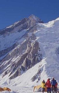
Gasherbrum III
| Gasherbrum III | |
|---|---|
 | |
| Highest point | |
| Elevation | 7,952 m (26,089 ft)[1][2] |
| Prominence | 461 m (1,512 ft)[1] |
| Coordinates | 35°44′N 76°38′E / 35.733°N 76.633°ECoordinates: 35°44′N 76°38′E / 35.733°N 76.633°E |
| Geography | |
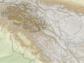 Gasherbrum III Location of Gasherbrum III | |
| Location | Baltistan, Gilgit-Baltistan, Pakistan Xinjiang, China[3] |
| Parent range | Karakoram |
| Climbing | |
| First ascent | 1975 by a Polish team |
| Easiest route | snow/ice climb |


Gasherbrum III (Urdu: گاشر برم -3; simplified Chinese: 加舒尔布鲁木III峰; traditional Chinese: 加舒爾布魯木III峰; pinyin: Jiāshūěrbùlǔmù III Fēng), surveyed as K3a, is a summit in the Gasherbrum massif of the Baltoro Muztagh, a subrange of the Karakoram on the border between Xinjiang, China and Gilgit-Baltistan, Pakistan.[3] It is situated between Gasherbrum II and IV.
Gasherbrum III fails to meet a 500 metres (1,600 ft) topographic prominence cutoff to be an independent mountain; hence it can be considered a subpeak of Gasherbrum II.[4]
Gasherbrum III was one of the highest unclimbed summits in the world[5] up to its first ascent in 1975, by Wanda Rutkiewicz, Alison Chadwick-Onyszkiewicz, Janusz Onyszkiewicz and Krzysztof Zdzitowiecki, members of a Polish expedition.
See also[]
- List of mountains in Pakistan
- List of highest mountains
Notes and references[]
- ^ a b "Gasherbrum III". Peakbagger.com. Retrieved 2014-08-24.
- ^ "Trekking Routes - Highest peaks". Central Karakoram National Park. Retrieved 2014-08-24.
- ^ a b This region is also claimed by India. This massif is under the control of Pakistan; it lies just north of the Line of Control.
- ^ Some sources use a lower cutoff value, and consider Gasherbrum III to be independent.
- ^ In fact no summit in 1975 was both higher and more topographically prominent.
This Gilgit-Baltistan location article is a stub. You can help Wikipedia by . |
- Seven-thousanders of the Karakoram
- Mountains of Gilgit-Baltistan
- Gilgit-Baltistan geography stubs