
Gauriganj, India
This article relies largely or entirely on a single source. (June 2019) |
Gauriganj | |
|---|---|
Town | |
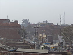 Gauriganj skyline | |
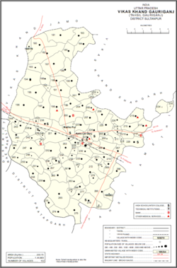 Map of Gauriganj CD block | |
 Gauriganj Location of Gauriganj in Uttar Pradesh | |
| Coordinates: 26°12′22″N 81°41′24″E / 26.206°N 81.690°E | |
| Country | |
| State | Uttar Pradesh |
| District | Amethi |
| Government | |
| • MLA | Rakesh Pratap Singh[1] |
| Elevation | 104 m (341 ft) |
| Population (2011) | |
| • Total | 326,723 |
| • Density | 855/km2 (2,210/sq mi) |
| Language | |
| • Official | Hindi[2] |
| • Additional official | Urdu[2] |
| Time zone | UTC+5:30 (Indian Standard Time) |
| Postal code | 227409 |
| Telephone code | 05-368 |
| Sex ratio | 904:1000 ♂/♀ |
| Vehicle Registration | UP-36 |
Gauriganj is a town and administrative headquarters of Amethi district in Faizabad division, Uttar Pradesh, India. It is situated about 126 km from Lucknow, the capital of Uttar Pradesh. It is located in Eastern Uttar Pradesh. Before July 2010, Gauriganj was part of Sultanpur district and then taking Gauriganj, Amethi, Jais, Jagdispur, Salon etc. formed a new district called "Chatrapati Sahuji Maharaj Nagar", later named Gauriganj and now Amethi. From Gauriganj a railway network is supplied to big cities in Uttar Pradesh and other states to Lucknow, Haridwar, Delhi, New Delhi, Kanpur, Allahabad, Varanasi, Howrah, Dehradun, Ambala, Amritsar . It is an industrial area. It has a well-developed marketplace where all types of goods and services can be purchased. The market was built by Raja Madho Singh of Amethi and was one of the most important grain markets in the district. There is a temple of Lord Shiva and Ram-Janaki besides a mosque near Ramlila ground. Gauriganj is connected with State Highway 34 and National Highway 128. Nearby cities are Sultanpur, Rae Bareilly, Ayodhya and Faizabad. People of many different castes and religions live here. Gauriganj has a warm subtropical climate with very cold and dry winters and hot and humid summers. The divine goddess Gauri is the major deity of Gauriganj and the town named after her.
It has a population of 326,723, of which 165,284 are males and 161,439 are females. There are about 56,787 households living in the region.
Gauriganj hosts a grain market on Mondays and Fridays.[3]
Geography[]
Climate[]
Gauriganj has a warm subtropical climate with very cold and dry winters from December to mid-February, and dry, hot summers from April to mid-June. During extreme winters, the maximum temperature is around 12 degrees Celsius and the minimum is around 3 to 4 degrees Celsius. Fog is quite common from late December to late January. Summers can be quite hot with temperatures rising to 40 to 45 degrees Celsius.
Gauriganj has a tropical wet and dry climate with average temperatures ranging between 20 and 28 °C (68 to 82 °F). Gauriganj experiences three distinct seasons: summer, monsoon and a mild autumn. Typical summer months are from March to May, with maximum temperatures ranging from 30 to 45 °C (86 to 100 °F). Although summer doesn't end until May, the city often receives heavy thundershowers in May, and humidity remains high. The rainy season is from mid-June to mid-September, when it gets an average rainfall of 722 mm, mostly from the south-west monsoon winds. Even during the hottest months, the nights are usually cool due to Gauriganj's altitude. The highest temperature ever recorded was 48.3 °C (118.9 °F). The monsoon lasts from June to October, with moderate rainfall and temperatures ranging from 10 to 28 °C (50 to 82 °F). Autumn begins in November. The daytime temperature hovers around 28 °C (82 °F) while the night temperature is below 10 °C (50 °F) for most of December and January, often dropping to 3 to 4 °C (37 to 39 °F).
History[]
At the turn of the 20th century, Gauriganj was described as "a rising town, with a station on the Oudh and Rohilkhand Railway."[4] It then technically consisted of two villages, and .[4] The bazar was founded by Madho Singh, the Raja of Amethi (d.1891).[4] Gauriganj then hosted a rising grain market and had a pound, police station, and post office, as well as an upper primary school, which had many students from both Gauriganj itself and the surrounding countryside; it had a small building, though, which was not big enough to accommodate the student body adequately.[4] The town was then surrounded by several deep hollows.[4] West of Katra-Lalganj were low-lying fields where only rice was grown.[4] The population of Gauriganj as of 1901 was 2,543, including a large Bania community which was larger than any other town in the district except Sultanpur.[4] There was a Muslim minority of 194, and the rest of the town's population was a mix of Ahirs, Kurmis, and Gadariyas, as well as some Pasis.[4]
The 1951 census recorded Gauriganj as having a district board-run primary school, with 201 students in attendance as of 1 January of the year.[5]
The 1961 census recorded Gauriganj as having a population of 1,883 people (1,038 male and 845 female), in 468 households and 456 physical houses..[3] It had a post office, a railway station, a library, and a government-run dispensary with 4 male and 2 female beds, as well as a maternity and child welfare centre and a family planning centre.[3] It had a police force of 2 sub-inspectors, 1 head constable, and 13 constables.[3] Average attendance of the grain market was about 2,000 at the time.[3]
Demographics[]
Languages and religion[]
Hindi and Urdu are the official languages. Awadhi is also widely spoken along with English.
Hinduism is followed by large numbers of the population. A significant part of the population of the city consists of followers of Islam and Sikhism. Christians and Jains constitute a minority of the population.
Culture[]
Durga Puja is celebrated in Gauriganj with cultural activities from the 8th day of Navratri for 14 days. Moorty Visarjan is also a big event as it takes approximately 90 hours to complete with thousands of indulged people. Krishna Janmashtami is also celebrated with great joy. In Some Aashram (likes: Baba Balak Das etc.) and some temples (e.g. Doodh Nath Mandir, Ram Janki Mandir, Hanuman Mandir) Feast (i.e. Vishal Bhog Bhandara) took places annually.[clarification needed]
Eid-ul-Fitr, Eid-ul-Adha, Eid Milad-un-Nabi and Shab-e-Barat are also celebrated in Gauriganj.
Places of interest[]
Villages[]
Gauriganj CD block has the following 102 villages:[6]
| Village name | Total land area (hectares) | Population (in 2011) |
|---|---|---|
| 194 | 795 | |
| 389.7 | 3,654 | |
| 464.1 | 2,086 | |
| 428.9 | 3,074 | |
| 273.4 | 1,208 | |
| 256.7 | 1,398 | |
| 190.1 | 1,538 | |
| 246.1 | 1,341 | |
| 504.1 | 3,865 | |
| 127 | 687 | |
| 191 | 1,883 | |
| 194 | 1,402 | |
| 290.2 | 2,303 | |
| 45.4 | 107 | |
| 178.4 | 603 | |
| 379.8 | 1,872 | |
| 345.7 | 2,153 | |
| 665.2 | 4,716 | |
| 432.8 | 2,078 | |
| 361.6 | 2,564 | |
| 187.7 | 1,384 | |
| 393.2 | 2,255 | |
| 266.3 | 2,690 | |
| 29 | 294 | |
| 44.4 | 118 | |
| 156.3 | 1,072 | |
| 101 | 586 | |
| 176.8 | 1,018 | |
| 236.1 | 1,892 | |
| 95 | 1,037 | |
| 88.9 | 418 | |
| 83.7 | 1,950 | |
| 78.6 | 417 | |
| 38.2 | 333 | |
| 55.6 | 685 | |
| 51.1 | 233 | |
| 152.2 | 1,222 | |
| 220.6 | 1,563 | |
| 158.8 | 1,012 | |
| 48.6 | 402 | |
| 125.5 | 984 | |
| 231.1 | 1,557 | |
| Barna Tikar | 447.5 | 2,927 |
| 179.2 | 4,717 | |
| 107.3 | 2,028 | |
| 231.8 | 1,738 | |
| 235.8 | 2,185 | |
| 218.5 | 737 | |
| 158.9 | 1,387 | |
| 230.1 | 5,834 | |
| 112.6 | 1,449 | |
| 123.6 | 799 | |
| 61.8 | 360 | |
| 68.1 | 549 | |
| 174.3 | 1,195 | |
| 135.8 | 966 | |
| 44.3 | 503 | |
| 183.5 | 1,298 | |
| 73.7 | 653 | |
| 51 | 214 | |
| 63.4 | 493 | |
| Jagmalpur | 113.9 | 520 |
| 293.1 | 1,053 | |
| Gvjar Tol | 141.4 | 1,102 |
| 312.2 | 1,685 | |
| Dharu Pur | 117 | 1,112 |
| 376.2 | 1,693 | |
| Biswan | 59.2 | 353 |
| Asura | 123.1 | 803 |
| Dhanapur | 110 | 953 |
| Bhawan Shah Pur | 129 | 821 |
| Lugri | 314 | 1,148 |
| Pachehri | 234.1 | 1,403 |
| 84.3 | 494 | |
| Raghipur | 60 | 1,207 |
| 94.1 | 337 | |
| 210.3 | 1,072 | |
| 199.7 | 1,329 | |
| 244.4 | 1,417 | |
| 194 | 1,828 | |
| 225.4 | 1,322 | |
| 126.2 | 381 | |
| 162.2 | 895 | |
| 112.2 | 1,056 | |
| Saintha | 639.6 | 4,076 |
| 360.8 | 2,031 | |
| 147 | 1,066 | |
| 193.4 | 1,787 | |
| 168.9 | 1,020 | |
| 63.1 | 278 | |
| 122.4 | 1,226 | |
| 460 | 3,063 | |
| 116.9 | 1,369 | |
| 221.4 | 1,449 | |
| 404.9 | 2,682 | |
| 52 | 427 | |
| 153.1 | 1,093 | |
| 412 | 2,513 | |
| 106 | 874 | |
| 495 | 2,561 | |
| 17.1 | 267 | |
| 125.1 | 422 | |
| Block total | 144,669 | 20,372.8 |
| Village name | Total land area (hectares) | Population (in 2011) |
Gallery[]

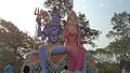
Bhandara at Baba Balak Das Ashram, Stage (2011)

Bhandara at Baba Balak Das Ashram (2011)
Hanuman Mandir, Madhopur


Notable people[]
- Manoj Muntashir is an Indian lyricist, poet and screenwriter was born in this town.
- Deepak Singh, politician and member of Uttar Pradesh Legislative Council
- Jagdish Piyush, Journalist, writer, author and leader
References[]
- ^ "Uttar Pradesh Legislative Assembly (UPLA): Member info". www.upvidhansabhaproceedings.gov.in. Retrieved 14 October 2019.
- ^ a b "52nd Report of the Commissioner for Linguistic Minorities in India" (PDF). nclm.nic.in. Ministry of Minority Affairs. Archived from the original (PDF) on 25 May 2017. Retrieved 11 January 2018.
- ^ a b c d e Census 1961: District Census Handbook, Uttar Pradesh (44 - Sultanpur District) (PDF). Lucknow. 1965. pp. 118, 121–2, 147, xxxviii–xxxix. Retrieved 13 December 2021.
- ^ a b c d e f g h Nevill, H.R. (1903). Sultanpur: A Gazetteer, Being Volume XLVI Of The District Gazetteers Of The United Provinces Of Agra And Oudh. Allahabad: Government Press. pp. 178–9. Retrieved 13 December 2021.
- ^ Census of India, 1951: District Census Handbook Uttar Pradesh (49 - Rae Bareli District) (PDF). Allahabad. 1955. p. 198. Retrieved 13 December 2021.
- ^ "Census of India 2011: Uttar Pradesh District Census Handbook - Sultanpur, Part A (Village and Town Directory)" (PDF). Census 2011 India. pp. 181–98. Retrieved 13 December 2021.
- Cities and towns in Amethi district