Gaztambide (Madrid)
Gaztambide | |
|---|---|
Ward of Madrid | |
 | |
 | |
| Country | Spain |
| Autonomous community | Madrid |
| Municipality | Madrid |
| District | Chamberí |
| Area | |
| • Total | 0.506596 km2 (0.195598 sq mi) |
| Population | 23,038 |
| • Density | 45,000/km2 (120,000/sq mi) |
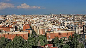
Gaztambide is an administrative neighborhood (barrio) of Madrid belonging to the district of Chamberí. It has an area of 0.506596 km2 (0.195598 sq mi).[1] As of 1 February 2021, it has a population of 23,038.[2]
| Wikimedia Commons has media related to Gaztambide neighborhood, Madrid. |
References[]
- ^ "Callejero vigente. Barrios". Ayuntamiento de Madrid. Retrieved 2 March 2021.
{{cite web}}: CS1 maint: url-status (link) - ^ "Población por distrito y barrio". Ayuntamiento de Madrid. Retrieved 2 March 2021.
{{cite web}}: CS1 maint: url-status (link)
Coordinates: 40°26′5″N 3°42′53″W / 40.43472°N 3.71472°W

This article about a location in the Community of Madrid, Spain is a stub. You can help Wikipedia by . |
Categories:
- Wards of Madrid
- Chamberí
- Gaztambide neighborhood, Madrid
- Madrid geography stubs