Gebsattel
Gebsattel | |
|---|---|
 Gebsattel Castle | |
 Coat of arms | |
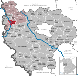
show Location of Gebsattel within Ansbach district | |
 Gebsattel | |
| Coordinates: 49°21′N 10°11′E / 49.350°N 10.183°ECoordinates: 49°21′N 10°11′E / 49.350°N 10.183°E | |
| Country | Germany |
| State | Bavaria |
| Admin. region | Mittelfranken |
| District | Ansbach |
| Municipal assoc. | Rothenburg ob der Tauber |
| Subdivisions | 3 Ortsteile |
| Government | |
| • Mayor (2020–26) | Gerd Rößler[1] |
| Area | |
| • Total | 19.12 km2 (7.38 sq mi) |
| Elevation | 378 m (1,240 ft) |
| Population (2020-12-31)[2] | |
| • Total | 1,731 |
| • Density | 91/km2 (230/sq mi) |
| Time zone | UTC+01:00 (CET) |
| • Summer (DST) | UTC+02:00 (CEST) |
| Postal codes | 91607 |
| Dialling codes | 09861 |
| Vehicle registration | AN |
| Website | www.gebsattel.de |


Gebsattel is a municipality in the district of Ansbach in Bavaria in Germany. It lies on the Tauber River.
Main sights[]

Catholic church of Saint Laurentius
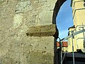
One of the old gates


Neighborhoods, districts[]
Gebsattel has nine neighborhoods or districts:[3]
- Bockenfeld
- Eckartshof
- Gebsattel
- Kirnberg
- Pleikartshof
- Rödersdorf
- Speierhof
- Wasenmühle
- Wildenhof
References[]
- ^ Liste der ersten Bürgermeister/Oberbürgermeister in kreisangehörigen Gemeinden, Bayerisches Landesamt für Statistik, 15 July 2021.
- ^ "Tabellenblatt "Daten 2", Statistischer Bericht A1200C 202041 Einwohnerzahlen der Gemeinden, Kreise und Regierungsbezirke". Bayerisches Landesamt für Statistik (in German). June 2021.
- ^ http://www.bayerische-landesbibliothek-online.de/orte/ortssuche_action.html?val=1338&attr=590&modus=automat&tempus=20110504/113342&hodie=20110807/165238
External links[]
| Wikimedia Commons has media related to Gebsattel. |
- Map of the municipality
- "Gebsattel: History of the coat-of-arms" (in German). Haus der Bayerischen Geschichte.
- Gebsattel: Official statistics compiled by the Bavarian State Office of Statistics (LfStat)
| show Towns and municipalities in Ansbach (district) |
|---|
| Authority control |
|---|
This Ansbach district location article is a stub. You can help Wikipedia by . |
Categories:
- Municipalities in Bavaria
- Ansbach (district)
- Middle Franconia geography stubs