Geldermalsen
Geldermalsen | |
|---|---|
Former municipality, town | |
 | |
 Flag Coat of arms | |
 Location in Gelderland | |
| Coordinates: 51°53′N 5°17′E / 51.883°N 5.283°ECoordinates: 51°53′N 5°17′E / 51.883°N 5.283°E | |
| Country | Netherlands |
| Province | Gelderland |
| Municipality | West Betuwe |
| Merged | 2019 |
| Area | |
| • Total | 101.73 km2 (39.28 sq mi) |
| • Land | 99.98 km2 (38.60 sq mi) |
| • Water | 1.75 km2 (0.68 sq mi) |
| Elevation | 4 m (13 ft) |
| Time zone | UTC+1 (CET) |
| • Summer (DST) | UTC+2 (CEST) |
| Postcode | 4150–4158, 4190–4197 |
| Area code | 0345 |
| Website | www |


Geldermalsen (Dutch pronunciation: [ˌɣɛldərˈmɑlsə(n)] (![]() listen)) is a town and former municipality in the province of Gelderland in the Netherlands.
listen)) is a town and former municipality in the province of Gelderland in the Netherlands.
Municipality of Geldermalsen[]
The municipality of Geldermalsen was formed on January 1, 1978, when the former municipalities of Beesd, Buurmalsen, Deil and Geldermalsen were combined. The municipality had an area of 101.73 km2 (39.28 sq mi) and was one of the largest municipalities in the Betuwe. The municipality had a population of in 2019. On 1 January 2019 it merged with Neerijnen en Lingewaal to form the new municipality West Betuwe.
The river Linge flows through the municipality and town of Geldermalsen.
Population centres[]
Town of Geldermalsen[]
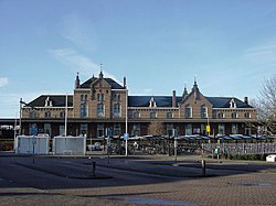
The town centre of Geldermalsen contains a two-aisled Gothic church dating from the 15th century, with a Romanesque tower dating from the 13th century. The town contains two windmills: De Watermolen, which was built in 1772, and De Bouwing, which was built in 1848. Located in the east side there is a graveyard.
Public high-school 'The Lingeborgh' is located in the west.
Demographics[]
Ethnic composition of Geldermalsen in 2010:
See also[]
References[]
- ^ "Kerncijfers wijken en buurten 2020" [Key figures for neighbourhoods 2020]. StatLine (in Dutch). CBS. 24 July 2020. Retrieved 19 September 2020.
- ^ "Postcodetool for 4191KH". Actueel Hoogtebestand Nederland (in Dutch). Het Waterschapshuis. Archived from the original on 21 September 2013. Retrieved 3 July 2014.
- ^ "Bevolkingsontwikkeling; regio per maand" [Population growth; regions per month]. CBS Statline (in Dutch). CBS. 1 January 2019. Retrieved 1 January 2019.
- ^ "Niet-westerse allochtonen per gemeente 2010-2040 - Nationale Atlas Volksgezondheid". Zorgatlas.nl. Archived from the original on 2016-10-02. Retrieved 2014-03-27.
External links[]
 Media related to Geldermalsen at Wikimedia Commons
- Official website
| show Places adjacent to Geldermalsen |
|---|
| show Authority control |
|---|
- West Betuwe
- Former municipalities of Gelderland
- Populated places in Gelderland
- States and territories established in 1978