Geography of Venezuela
 | |
| Continent | South America |
|---|---|
| Region | Caribbean |
| Coordinates | 8°00′N 66°00′W / 8.000°N 66.000°W |
| Area | Ranked 32nd |
| • Total | 912,050[1] km2 (352,140 sq mi) |
| • Land | 96.71% |
| • Water | 3.29% |
| Coastline | 2,800[1] km (1,700 mi) |
| Borders | 5,267 km (3,273 mi)[1] |
| Highest point | Pico Bolívar 4,978 m (16,332 ft)[1] |
| Lowest point | Caribbean Sea 0 metres (0 ft)[1] |
| Exclusive economic zone | 471,507 km2 (182,050 sq mi) |


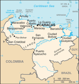
Venezuela is a country in South America, bordering the Caribbean Sea and the North Atlantic Ocean, between Colombia and Guyana. It is situated on major sea and air routes linking North and South America. Located at the northernmost end of South America, Venezuela has a total area of 912,050 km2 (352,140 sq mi) and a land area of 882,050 km2 (340,560 sq mi).[2][1] It is the 32nd largest country and is slightly smaller than Egypt, or half the size of Mexico. Shaped roughly like an inverted triangle, the country has a 2,800 km (1,700 mi) long coastline.[2][1] It is bound on the north by the Caribbean Sea and the Atlantic Ocean, on the east by Guyana, on the south by Brazil, and on the west by Colombia.[2] It has the 55th largest Exclusive Economic Zone of 471,507 km2 (182,050 sq mi). Its maritime territory borders Trinidad and Tobago, Dominica, the Dominican Republic, Grenada, St. Kitts and Nevis, St. Vincent and the Grenadines, France, the United Kingdom, the Netherlands, and the United States. Venezuela also claims the region of Guayana Esequiba, currently under the control of Guyana.
Topography[]
Most observers describe Venezuela in terms of four fairly well-defined regions: the Maracaibo lowlands in the northwest, the northern mountains extending in a broad east–west arc from the Colombian border along the Caribbean Sea, the wide Orinoco plains (Llanos) in central Venezuela, and rank highly dissected Guiana highlands in the southeast.[2]
The Maracaibo lowlands form a large spoon-shaped oval bounded by mountains on three sides and open to the Caribbean on the north.[2] The area is remarkably flat with only a gentle slope toward the center and away from the mountains that border the region.[2] Lake Maracaibo occupies much of the lower-lying territory.[2] Areas around the southern part of Lake Maracaibo are swampy, and, despite the rich agricultural land and significant petroleum deposits, the area was still thinly populated as of 1990.[2][needs update]
The mountains bordering the Caribbean Sea are actually the northeasternmost extension of the Andes chain.[2] Broken by several gaps, these high mountains have peaks over 4,500 metres (14,800 ft); the fertile valleys between the ranges contain most of Venezuela's population, industry, and agriculture.[2] The discontinuous westernmost range runs along the Colombian border and is the least densely populated part of this region.[2] The ranges southeast of Lake Maracaibo contain some of the highest peaks in the country (Pico Bolivar reaches 4,978 m (16,332 ft)), a few of which are snowcapped year-round.[2][1]
A broad gap separates this mountainous area from another rugged pair of ranges that parallel the north-central coast.[2] The series of valleys between these two parallel ranges constitute the core area of the country; as the site of burgeoning metropolitan Caracas, this comparatively small area hosts the country's densest population, the most intensive agriculture, and the best transportation network.[2] Another broad gap separates this area from the easternmost group of mountains, a series of dissected hills and uplands that rise steeply from the Caribbean and extend eastward almost to Trinidad.[2]
The great expanse of lowlands known as the Orinoco plains extends westward from the Caribbean coast to the Colombian border between the northern mountains and the Rio Orinoco.[2] This region is commonly known as the llanos, although it also contains large stretches of swampland in the Orinoco Delta and near the Colombian border.[2] The area slopes gradually away from the highland areas that surround it; elevations in the llanos never exceed 200 metres (660 ft).[2] North of the Rio Apure, rivers flowing out of the northern mountains cut shallow valleys, leaving eroded ridges that give the land a gently rolling appearance.[2] South of the Apure, the terrain is flatter and elevations lower.[2]
One of the oldest land forms in South America, the Guiana highlands rise almost immediately south and east of the Rio Orinoco.[2] Erosion has created unusual formations in this region.[2] Comprising over half of the country, the highlands consist primarily of plateau areas scored by swiftly running tributaries of the Orinoco.[2] The most conspicuous topographical feature of the region is the Gran Sabana, a large, deeply eroded high plateau that rises from surrounding areas in abrupt cliffs up to 800 metres (2,600 ft).[2] Above the rolling surface of the Gran Sabana, massive, flat-topped bluffs emerge; many of these bluffs (referred to as tepuis by the Venezuelans) reach considerable altitudes.[2] The most famous tepui contains Angel Falls, the world's highest waterfall.[2]
Climate[]
Although the country lies wholly within the tropics, its climate varies from tropical humid to alpine, depending on the elevation, topography, and the direction and intensity of prevailing winds.[2] Seasonal variations are marked less by temperature than by rainfall.[2] Most of the country has a distinct rainy season; the rainy period (May through November) is commonly referred to as winter and the remainder of the year as summer.[2]
Average yearly rainfall amounts in the lowlands and plains range from an arid 180 mm (7 in) in the Paraguaná Peninsula – the driest part of South America outside the Arid Diagonal[citation needed] – to around 1,000 mm (39 in) in the Orinoco Delta[2] and 2,200 mm (87 in) or more in Los Llanos and Amazonas.[citation needed] Rainfall in mountainous areas varies considerably; sheltered valleys receive little rain, but slopes exposed to the northeast trade winds experience heavy rainfall.[2] Caracas averages 800 mm (31 in) of precipitation annually, with very little rain falling from December to April.[2][3]
The country falls into four temperature zones based primarily on elevation. In the tropical zone—below 800 m (2,600 ft)—temperatures are hot, with yearly averages ranging between 26 and 28 °C (79 and 82 °F).[2] The temperate zone ranges between 800 and 2,000 m (2,600 and 6,600 ft) with averages from 12 to 25 °C (54 to 77 °F); many of Venezuela's cities, including the capital, lie in this region.[2] Colder conditions with temperatures from 9 to 11 °C (48 to 52 °F) are found in the cool zone between 2,000 and 3,000 m (6,600 and 9,800 ft).[2] Pastureland and permanent snowfield with yearly averages below 8 °C (46 °F) cover land above 3,000 m (9,800 ft) in the high mountain areas known as the páramos.[2]
Hydrography[]
The Orinoco is by far the most important of the more than 1,000 rivers in the country.[2] Flowing more than 2,500 kilometers to the Atlantic from its source in the Guiana highlands at the Brazilian border, the Orinoco is the world's eighth largest river and the largest in South America after the Amazon.[2] Its flow varies substantially by season, with the high water level in August exceeding by as much as thirteen meters the low levels of March and April.[2] During low water periods, the river experiences high and low tides for more than 100 kilometers upstream from Ciudad Guayana.[2]
For most of the river's course, the gradient is slight.[2] Downstream from its headwaters, it splits into two; one-third of its flow passes through the Brazo Casiquiare (Casiquiare Channel) into a tributary of the Amazon, and the remainder passes into the main Orinoco channel. This passageway allows vessels with shallow drafts to navigate from the lower Orinoco to the Amazon River system after unloading and reloading on either side of two falls on the Orinoco along the Colombian border.[2]
Most of the rivers rising in the northern mountains flow southeastward to the Río Apure, a tributary of the Orinoco. From its headwater, the Apure crosses the llanos in a generally eastward direction.[2] Few rivers flow into it from the poorly drained region south of the river and much of this area near the Colombian border is swampland.[2]
The other major Venezuelan river is the fast-flowing Caroní, which originates in the Guiana highlands and flows northward into the Orinoco upstream from Ciudad Guyana.[2] The Caroní is capable of producing as much hydroelectric power as any river in Latin America and has contributed significantly to the nation's electric power production. Electricity generated by the Caroní was one of the factors encouraging industrialization of the northern part of the Guiana highlands and the lower Orinoco valley.[2]
Lake Maracaibo occupies the central 13,500 square kilometers of the Maracaibo lowlands.[2] The low swampy shores of the lake and areas beneath the lake itself hold most of Venezuela's rich petroleum deposits.[2] The lake is shallow, with an average depth of ten meters, and separated from the Caribbean by a series of islands and sandbars.[2] In 1955 a 7.5-meter channel was cut through the sandbars to facilitate shipping between the lake and the Caribbean.[2] The channel also allows salt water to mix with the yellowish fresh water of the lake, making the northern parts brackish and unsuited for drinking or irrigation.[2]
A recent global remote sensing analysis suggested that there were 732 km2 (283 sq mi) of tidal flats in Venezuela, making it the 36th ranked country in terms of tidal flat extent.[4]
Extreme points[]
- Northernmost point – Isla Aves
- Northernmost point (mainland) – Cape San Román
- Southernmost point – Border with Brazil, Río Negro Municipality, Amazonas
- Westernmost point – Border with Colombia, Zulia State
- Easternmost point – Border with Guyana, near Caribbean sea coast, Delta Amacuro State
- Highest point – Pico Bolívar: 4,978 m (16,332 ft)[1]
- Lowest point – Caribbean Sea: 0 m[1]
References[]
- ^ a b c d e f g h i j "Venezuela", The World Factbook, Central Intelligence Agency, 12 November 2021, retrieved 12 November 2021.
 This article incorporates text from this source, which is in the public domain.
- ^ a b c d e f g h i j k l m n o p q r s t u v w x y z aa ab ac ad ae af ag ah ai aj ak al am an ao ap aq ar as at au av aw ax ay Haggerty, Richard A., ed. (1993). Venezuela: a country study (4th ed.). Washington, D.C.: Federal Research Division, Library of Congress. ISBN 0-8444-0747-X. OCLC 25633004. This article incorporates text from this source, which is in the public domain.
{{cite encyclopedia}}: CS1 maint: postscript (link) - ^ Kent, Robert B. (2016). Latin America: Regions and People (2nd ed.). Guilford Publications. p. 135. ISBN 978-1-4625-2550-8.
- ^ Murray, N.J.; Phinn, S.R.; DeWitt, M.; Ferrari, R.; Johnston, R.; Lyons, M.B.; Clinton, N.; Thau, D.; Fuller, R.A. (2019). "The global distribution and trajectory of tidal flats". Nature. 565 (7738): 222–225. doi:10.1038/s41586-018-0805-8. PMID 30568300. S2CID 56481043.

- Geography of Venezuela