Geography of Vojvodina
This article does not cite any sources. (November 2012) |

Vojvodina general map

Map showing main geographical regions in Vojvodina, as well as cities and towns.

Geographical-historical borders of Vojvodina and geographical sub-regions in Vojvodina

Detailed map of the south-eastern part of Pannonian Sea (modern territory of Vojvodina) during the Miocene Epoch.
Vojvodina is an autonomous region within Serbia located in the Pannonian plain, a region of central Europe. It shares borders with Romania in the east, Hungary in the north, Croatia in the west, and Bosnia and Herzegovina in the southwest. The southern border is administrative line to Šumadija and Western Serbia, Belgrade, and Southern and Eastern Serbia.
Geographical regions of Vojvodina[]
Mountains and hills[]
Sands[]
Rivers[]
Canals[]
- Canal Danube-Tisa-Danube, and some larger canals part of DTD system:
- Begej canal
- Jegrička canal
- Jarčina canal
Lakes and bogs[]
- Palićko lake
- Ludoško lake
- Ledinačko lake
- Obedska bog
Gallery[]
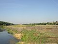
A landscape from Vojvodina, near the village of Skorenovac
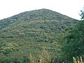
The highest point in Vojvodina

Typical plains landscape of Vojvodina


External links[]
| Wikimedia Commons has media related to Geography of Vojvodina. |
Categories:
- Geography of Vojvodina