Bosut (river)
| Bosut | |
|---|---|
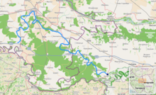
 Bosut between Rokovci and Andrijaševci | |
 Bosut location [1] | |
| Location | |
| Countries | |
| Physical characteristics | |
| Source | |
| • location | Dilj/Cerna, Croatia |
| Mouth | |
• location | Sava at the village of Bosut, Serbia |
• coordinates | 44°56′28″N 19°22′14″E / 44.9411°N 19.3706°ECoordinates: 44°56′28″N 19°22′14″E / 44.9411°N 19.3706°E |
| Length | 186 km (116 mi) [1] |
| Basin size | 2,943 km2 (1,136 sq mi) [1] |
| Basin features | |
| Progression | Sava→ Danube→ Black Sea |

The Bosut (Serbian Cyrillic: Босут) is a river in eastern Croatia and northwestern Serbia, a 186 km long left tributary of the Sava river.[2] Its name from the Indo-European root *bhogj, meaning "to flow". The same root is seen in hydronym "Bosna".[3]
Course[]
Headwaters[]
The Bosut originates as the Biđ (or Bič) river in central Slavonia region, on the southern slopes of the Dilj mountain, northwest of the city of Slavonski Brod. Generally flowing to the northeast, it has no major settlements though some larger villages are in the vicinity of the river (Donji Andrijevci, Vrpolje and Strizivojna). Biđ is 66 km (41 mi) long.[4]
The Berava is a small river that rises south of Velika Kopanica, meanders eastwards near Gundinci and Babina Greda, and turns north near Gradište, south of Cerna.
Downstream of Cerna[]
In the village of Cerna, the Biđ receives the river Berava from the south and from this point it is known as the Bosut. Some maps though, indicate that name Bosut is used before the river reaches Cerna, and some other apply the name also for the lowest part of the Berava's course, between Gradište and Cerna.[citation needed]
Turning north from there, the river flows into the region of Syrmia, and the villages of Andrijaševci and Rokovci, reaching the biggest settlement on its course, the city of Vinkovci. From there, the rivers turns to the southeast, which is the direction it will follow for the rest of its course, except for a large U-bend south of Vinkovci. It passes through , Nijemci, Podgrađe, Apševci and Lipovac, where it receives the river Spačva from the right, and after the flow of 151 km through Croatia,[2] crosses the Serbian border.
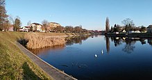
The Bosut enters Serbia at the village of Batrovci and flows through the southwesternmost part of the province of Vojvodina. It continues through the villages of Morović (where it receives the river Studva from the right, its major tributary in Serbia) and Višnjićevo, makes a turn north of Sremska Rača and, after 28 km in Serbia, empties into the Sava at the village of Bosut. A pond, near Morović, is located in the river's valley.
Characteristics[]
The Bosut belongs to the Black Sea drainage basin, with its own drainage area of 3,097 km2 (1,196 sq mi) (of which 2,572 km2 (993 sq mi) in Croatia).[2] For some 40 km it is navigable for smaller vessels.
The river is known as meandering and extremely slow, and it has a very small inclination in its basin - less than 10 m from Vinkovci until its mouth. Bosut is known for a phenomenon of being 'the river that flows backwards', because sometimes, with strong winds and being so slow, it appears as if the water is flowing backwards.
The whole valley of the Biđ-Bosut is actually an old, fossil river bed of the Sava. It is also known as a region with the highest evaporation in both Croatia and Serbia. In its lower course, Bosut flows through a forested area in the region of Spačva. The river is generally known for its abundance of fish.
See also[]
References[]
- ^ Jump up to: a b "Sava River Basin Analysis Report" (PDF, 9.98 MB). International Sava River Basin Commission. September 2009. p. 14. Retrieved 2018-05-18.
- ^ Jump up to: a b c Ostroški, Ljiljana, ed. (December 2015). Statistički ljetopis Republike Hrvatske 2015 [Statistical Yearbook of the Republic of Croatia 2015] (PDF). Statistical Yearbook of the Republic of Croatia (in Croatian and English). 47. Zagreb: Croatian Bureau of Statistics. p. 49. ISSN 1333-3305. Retrieved 27 December 2015.
- ^ http://hrcak.srce.hr/file/76828
- ^ "Statistic description of Brod Regimente in third decade of 19th century". Scrinia Slavonica (in Croatian). 3 (1). November 2003.
- Mala Prosvetina Enciklopedija, Third edition (1985); Prosveta; ISBN 86-07-00001-2
- Jovan Đ. Marković (1990): "Enciklopedijski geografski leksikon Jugoslavije"; Svjetlost-Sarajevo; ISBN 86-01-02651-6
External links[]
| Wikimedia Commons has media related to Bosut River. |

| show Šid Municipality |
|---|

- Tributaries of the Sava
- Rivers of Croatia
- Rivers of Serbia
- Geography of Vojvodina
- International rivers of Europe
- Slavonia
- Syrmia
- Geography of Vukovar-Syrmia County