Geology of Indonesia
This article includes a list of general references, but it remains largely unverified because it lacks sufficient corresponding inline citations. (September 2016) |

This is a brief summary of the geology of Indonesia. Indonesia is located between two tectonic plates. The Eurasian Plates and the Australian Plates.
Tectonics[]
The tectonics of Indonesia are very complex, as it is a meeting point of several tectonic plates. Indonesia is located between two continental plates: the Eurasian Plate (Sunda Plate) and Australian Plate (Sahul Shelf); and between two oceanic plates: the Philippine Sea Plate and Pacific Plate.
The subduction of the Indian oceanic plate beneath the Eurasian continental plate formed the volcanic arc in western Indonesia, one of the most seismically active areas on the planet with a long history of powerful eruptions and earthquakes. This chain of active volcanoes formed Sumatra, Java, Bali, and Nusa Tenggara islands, most of which, particularly Java and Bali, emerged within the last 2–3 million years. The Pacific and Australian plate movements controlled the tectonics of the eastern portion of Indonesia.
Structural geology[]
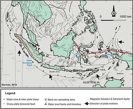
The tectonics processes in Indonesia formed major structures in Indonesia. The most prominent fault in the west of Indonesia is the Semangko Fault or the Great Sumatran Fault, a dextral strike-slip fault along Sumatra Island (about 1900 km). The formation of this fault zone is related to the subduction zone in the west of Sumatra.
Palu-Koro fault is another major structural feature formed in the central part of Indonesia. This fault runs across the central part of Sulawesi Island and extends offshore to the west across Makassar Strait and ends in the Mangkalihat Peninsula in Borneo. The fault is named after the capital city of Central Sulawesi, Palu, on the west coast of Sulawesi and the Koro River, which is formed by the fault zone.
Sorong fault is a significant left lateral fault in the eastern part of Indonesia, named after Sorong City. It has east-west orientation and extends from the northern part of West Papua to East Sulawesi for about 2000 km.
Indonesian Seaway[]
The various formations in the Indonesian archipelago and New Guinea's Torres Strait form geologic choke points to shipping and aqueous transport, particularly at depths below 100m (where said aqueous transport is largely closed); such routes, whether closed or still extant, collectively comprise the Indonesian Seaway between the Pacific and Indian Oceans. Tectonic uplift of the region, exacerbated by lowered sea levels during recent glaciation, is hypothesized to have altered the regional climate, especially with respect to monsoons, beginning ~4 million years ago.[1]
Stratigraphy[]
The stratigraphy of the western part of Indonesia is dominated by Cenozoic age formations, ranging from Paleogene to Quaternary. Minor Mesozoic and Paleozoic formations were found in places. Devonian limestones were found in Telen River, East Kalimantan, as fragments within Paleogene clastic sediments.
Eastern Indonesia has generally older stratigraphy compared to the western part. The stratigraphy ranges from Permian to Tertiary. Ichthyosaur fossils were found in the mud volcanoes in Kai Island, indicating Mesozoic deposition in the subsurface (Charlton, 1992). Mesozoic macrofossils were studied in Misool Island by Fauzie Hasibuan (1996)

See also[]
- Volcanology of Indonesia
- List of earthquakes in Indonesia
References[]
- ^ Cane1, Mark A.; Molnar, Peter (10 May 2001). "Closing of the Indonesian seaway as a precursor to east African aridification around 3–4 million years ago". Nature. Nature Research. 411 (6834): 157–162. doi:10.1038/35075500. PMID 11346785.
- Bemmelen, R. W. van (Reinout Willem van) The Geology of Indonesia The Hague : Govt. Printing Office, 1949. 2 volumes.
- Charlton, T., 2004, The petroleum potential of inversion anticlines in the Banda Arc, AAPG Bulletin, V. 88, No. 5 (May 2004), P. 565-585.
- Darman, H. & Sidi, H. (eds.), 2000, An Outline of the Geology of Indonesia, Indonesian Geologists Association publication.
- Hasibuan F., 2012, Mesozoic Geology and Paleontology of Misool Archipelago, Eastern Indonesia, Geological Agency, Ministry of Energy and Mineral Resources, Republic of Indonesia.
External links[]
| Wikimedia Commons has media related to Geology of Indonesia. |
- Seismic Atlas of SE Asia Basins
- The Geology of Indonesia: Wikibook Edition (online)
- IAGI, Ikatan Ahli Geologi Indonesia (the Indonesian Association of Geologists)
- FOSI, Forum Sedimentologiwan Indonesia (the Indonesian Sedimentologists Forum)
- Geology of Indonesia Blog
| Wikibooks has a book on the topic of: The Geology of Indonesia |

| show Geology of Asia |
|---|
- Geology of Indonesia
- Natural history of Indonesia
- Geology by country