Geology of the Western Carpathians
The Western Carpathians are an arc-shaped mountain range, the northern branch of the Alpine-Himalayan fold and thrust system called the Alpide belt, which evolved during the Alpine orogeny. In particular, their pre-Cenozoic evolution is very similar to that of the Eastern Alps, and they constitute a transition between the Eastern Alps and the Eastern Carpathians.
The geological evolution of individual parts of the chain is complex, a result of tectonic processes like folding, thrusting and the formation of sedimentary basins of various types during the Mesozoic and Cenozoic. These processes sometimes affected not only the sedimentary fill of the basins, but also, in some cases, the former basement.
Many aspects of the geological structure of the Western Carpathians have not been completely studied and are subject to ongoing research and debate. The appropriate classification of a number of specific is still not clear.
Geological definition[]

The Western Carpathians are separated from the Alps by the valley of the river Danube (only from the geographical point of view; the geological boundary is the so-called ) and the .[1] To the east, the boundary with the Eastern Carpathians is placed formally in the valley of the river Uzh, but many tectonic divisions consider the on the line Košice – Prešov the real geological boundary.[1] The northern boundary is the that separates the nappes from the . In Bohemia the line Znojmo-Přerov-Karviná approximately forms the western boundary of the Western Carpathians.[2] The southern boundary is not distinct (because of the interfingering boundary between the Carpathians and lowlands of the Pannonian Basin). According to some views it is south of the Bükk and Mátra mountains in Hungary.
Geological structure[]
There are several interpretations of the tectonic structure of the Western Carpathians. For quite a long time, the triple division has been used (Outer, and Inner Western Carpathians),[3][4][5][6] while some geologists prefer the classical double division (Outer and Inner Carpathians).[7][8][9] Other ideas of division may differ, such as morphotectonic (based on geology and geomorphology[3][8]) or regional geology.[5] Tectonic division applied in this article is based on the division of and others[5] in 1997, later modified in 1999[6] and in 2002 together with ,[10] although it cannot be considered definitive.
The three main areas of the Inner, Central, and Outer Western Carpathians are divided by two sutures. The Meliata suture is an area of closure of the Triassic-Jurassic during the Kimmerian phase. It constitutes the boundary between the and Inner Western Carpathians. The position of the boundary is disputable; different authors place the Meliata suture in different areas. It is identified with the , , or possibly placed even more to the South. The second important suture is called the , roughly copying the structure of Pieniny Klippen Belt. This important dislocation divides the Central and Outer Western Carpathians. Deeper under the sediments it constitutes the boundary between the Central Carpathian basement rocks and the foreland – the Bohemian Massif and East European craton (). Since the 1980s the dividing line has been considered the suture of the – the Eastern continuation of the Piemont-Liguria Ocean.[4]

Foreland[]
The foreland of the Western Carpathians in the West and North is composed of the Bohemian Massif and . In the Northeast it is formed by the rock of the East European craton. These areas were consolidated earlier than the Carpathians. The Bohemian Massif, which is the youngest part of the foreland, evolved during the Hercynian orogeny about 200 million years before the orogeny in the Carpathians.
Outer Western Carpathians[]
The Outer Western Carpathians were formed during orogeny that took part since the Upper Cretaceous (Senonian) and Miocene periods, which is later than the . Pieniny Klippen Belt was affected by thrusting together with the Central Carpathians and later folded and thrusted again together with the Flysch Belt.
Foredeep[]
Thrust of the Carpathians on their foreland caused a flexure of the lower continental plate under the frontal part of the nappes.[10] This area, called the , was filled by thick formations of molasse, prevailingly marls, sandstones and conglomerates that were formed in the Oligocene to Miocene periods by erosion of the growing Carpathians. Nevertheless, the foredeep is not generally folded; flysch nappes thrusted from the south partially folded the rock underneath. The whole zone of the foredeep is developed in the foreland of the Alps, and runs through the Moravia to the Ostrava Basin and further East to Poland, Ukraine, and Romania.
Flysch Belt[]

The Flysch Belt was named after a characteristic alteration of sandstone and claystone, so called flysch, occurring in the Cretaceous to Paleogene (possibly Miocene) age in the area. The belt is the accretionary wedge of the Carpathians. The Flysch Belt also contains a small volume of Cenozoic volcanic rocks. The zone originally consisted of a set of more sedimentary basins that were in constant tectonic transformation. Raised parts of the basins formed elevations, which were eroded and supplied deeper parts of the basin with clastic sediments that were brought by turbidity currents. Orogeny affected the area at the end of the Paleogene and in the beginning of the Neogene in the so-called Savian phase. Other portions were also affected by the Styrian phase, which caused partial thrusting over the Foredeep. Nappes were formed by gradual compression of the sedimentary basins that caused their inversion and separation of sedimentary successions from their basement and their movement for distance of 20 – 30 km, and possibly more. Nappes were formed in two phases: the outer (Northern) or lower group of nappes called the , and the overriding internal (Southern) . Nappes are thrust over their foreland in the form of tectonic slices. At least part of the Flysch Belt was an Eastern continuation of the Alpine , probably the Valais branch. A direct continuation of the Alpine can be seen.[10] The Flysch Belt continues through Bohemia, Slovakia, and Poland, and joins the in the Ukraine and Romania.
Central Western Carpathians[]
The Central Western Carpathians, sometimes referred as the Slovakocarpathian system,[6] are a zone bounded by the Pieniny Klippen Belt from the North and the from the South. The Pieniny Klippen Belt is a relatively thin but important dividing line separating the Outer Western Carpathians from the internal zones of orogeny. Together with the similar units of the it constitutes the . The largest portion of the Western Carpathians consists of the zone built of granitic and metamorphic rock (that metamorphic grade is generally higher in the North and lower in the South), and sedimentary cover overridden by thrust nappes of Mesozoic carbonate rocks. The zone consists of the Tatra-Fatra Belt of core mountains, the , and the . In their predominantly crystalline basement zones called the , , and , thrusting (thick-skinned) is also present, but not as apparent. Geophysical investigation confirmed that the Gemeric is thrusted over the Veporic, and the Veporic over the Tatric.[11] The Central Western Carpathians formerly constituted a portion of the East European craton continental shelf, and were situated more to the West, in the area of the present Switzerland, laterally joining the Outer Carpathians (represented by the ). During the release of tension within the Alpine collision tectonic events, the stress was released to the flanks of the thrust belt, which caused the tectonic escape of the material. Central Western Carpathians were consequently pushed in the Northeast direction from the Alpine to Carpathian domain.
Považie-Pieniny Belt[]
The Považie-Pieniny Belt has a complicated imbricated structure, represented especially by the Pieniny Klippen Belt.[6] It consists of , , and , as well as Inner-Carpathian units (e.g. and etc.). Placement of the Pieniny Klippen Belt into the Central Western Carpathians is ambiguous, because most authors consider Pieniny Klippen Belt as part of the Outer Carpathians.[3] The Považie-Pieniny Belt is divided into three zones: the Brezová, Peri-Klippen, and Klippen zones.

Relatively thin and complicated, the Pieniny Klippen Belt creates a boundary, a tectonic suture, between the Outer and . Only rock younger than the Triassic is known in this zone. Exclusively nonmetamorphic sedimentary successions are composed especially of limestones and marls. In the Jurassic period, the ocean that opened in the area of the Pieniny Klippen Belt is called the (or the South Penninic). Its preserved sedimentary successions are in the present erosion cut known only from the unit. The Vahic domain was bounded from the North by the slopes of the , and from the South by the unit. The subsiding part of the Oravic unit formed the . The most shallow part of the Oravic unit was characterized by deposition of shallow water limestones of . To the South, closer to the deep water Kysuca Basin, other transitional units were deposited. In the deepest part of the Kysuca Basin, sediments of were deposited.[7] The Vahic domain had extended and deepened during its history. In the Upper Cretaceous to Paleocene, the thrusting of the southern units of Tatric caused inversion or subduction of the Vahic Ocean that was followed by collision of the Oravic and Tatric units. As a result of these processes, deformation and North vergent thrusting of the Oravic units in the form of nappes occurred. After the end of compression, marly and flysch-like sedimentation (so-called klippe envelope sediments) continued on the top of the nappe stack. Later in the Paleogene, another phase of orogeny affected the Pieniny Klippen Belt. It squeezed the former nappe stack and the rocks of different rheology (competent limestones, soft flysch, and marls) were deformed in different ways, which caused the rupture of more dense rock and ductile deformation of the less dense rock. Complicated arrangement of particular tectonic units was later affected by strike-slip motion in the area of the in the Miocene. Consequent erosion dissected the rigid limestone tectonic lenses to the shape of protruding klippes (e.g. in Western Slovakia). The zone of klippes stretches almost uninterrupted from the Podbranč in Western Slovakia to the in Northeastern Romanian.
Tatra-Fatra Belt of core mountains[]

South of the Pieniny Klippen Belt, the zone of core mountains is present. The core is formed by the unit composed predominantly by Paleozoic metamorphic rock, younger plutonic rock, and Carboniferous to Mesozoic sedimentary cover. Basement rock was formed during the Hercynian orogeny when a strong regional metamorphism affected the area. Paragneisses and amphibolites are most abundant, but low grade metamorphic rock is also present.[7] Later, at the end of Hercynian orogeny in the Carboniferous and Permian, the area was intruded by granitic rock and strongly affected by erosion, which affected even the deeply situated granites. The autochthonous Carboniferous, Permian and most commonly Mesozoic sediments are onlapping the crystalline basement. They are represented by greywackes, quartz sandstones, shales, limestones, and marls. Sedimentary cover of the Tatric unit is overridden by Mesozoic nappes. Nappes are large slabs of the Mesozoic carbonate rock with similar sedimentary sequence as present in the Tatric cover. There are two so-called : the lower called the (or the ) and the upper called (or the ). The Fatric is characterised by the occurrence of thicker formations of the .[4] The Hronic is typical with the occurrence of Permian andesitic-basalts[4] (so called ) and a larger thickness of variable Triassic carbonate rock.[7] Thrusting of the nappes took place in the Upper Cretaceous, probably during the Turonian. The whole area was not so rangy as it is today. Uplift of the mountains took place at the end of the Oligocene and in the Miocene. It caused the uplift of the horsts, usually asymmetric, on the South flank, steeply bounded by normal faults and slightly declining to the North flank. The crystalline basement is usually uncovered on the South flank of the horsts. The horsts form two rows of mountains. The northern (outer) row consists of the Malé Karpaty Mts. ( part and ), Považský Inovec Mts., Strážovské vrchy Mts., Malá Fatra Mts., and Tatra Mts. The Southern row of core mountains includes the Tríbeč Mts., Žiar Mts., Veľká Fatra Mts., Chočské vrchy Mts., The Eastern part of Nízke Tatry Mts. (so called Ďumbierske Tatry) and .[12]
Vepor Belt[]
The is a zone South of the belt of core mountains. The dividing line is called the . A characteristic feature of the Vepor belt is medium Alpine regional metamorphism. The largest area of this zone is formed by the unit. Crystalline basement rock is most abundant in this area, and the largest granitic pluton in the Western Carpathians is present here. It was formed during the Hercynian orogeny. Mesozoic sedimentary cover is preserved only locally. The Veporic unit was the root area of the () that was formerly situated in the inverted on the northern rim of the Veporic, close to the . Inversion of the basin took place in the Upper Cretaceous and was accompanied by intrusion of a small body of granite. In addition to nappe outliers of the (Hronic) and part of the (Fatric), there is also a large body of ().[3] The Veporic is partially thrusted over the Tatric and lies under the unit. The nappe stack of the Veporic and Gemeric later collapsed and evolved in the Veporic metamorphic core complex. The Vepor Belt forms the Eastern part of the Nízke Tatry Mts. (), Vepor Mts., Kozie chrbty Mts., southern portion of the Branisko Mts. and .[12] On the South it is divided from the Slovak Ore Mountains by the that is a gently dipping thrust fault.
Gemer Belt[]
The is a zone of predominantly crystalline rock, partially thrusted over the Veporic. The most important portion of the zone is the unit, unlike the other Carpathian units with signs of low grade (greenschist facies) Hercynian metamorphic overprint. The Gemeric is the uppermost basement-involved unit of the Central Western Carpathians. It is made by phyllites, quartzites, porphyries and limestones commonly metamorphosed to siderite and magnesite. Granites are less abundant. Permian volcanic activity formed the uraninite mineralization. Later, during the Mesozoic, limestones and dolomite were deposited. In the Upper Jurassic, after the closure of the , nappes of the and were thrust from the South. In the Upper Cretaceous, nappe was thrust over the previous. At the end of Paleogene, the Gemeric Belt was deformed and uplifted. This zone forms the Slovak Ore Mountains, , and Slovak Karst.[12]
Internal Western Carpathians[]
The are divided from the Central Western Carpathians by the , which is partly covered by the décollement nappes. The Rožňava line is largely a conceptual one and is perceived differently by different authors. According to assumptions, the fault joins the on the West. Other problem of exact definition of boundary between the Internal and Central Western Carpathians are views of the structure of the . The Internal Western Carpathians are composed generally of the tectonic units originating from the area of the former or South of it. This zone is built of the , , , and . There are large nappes of Mesozoic carbonates (, , ), which are not affected by metamorphism and are characteristic with typical affinity to the South Alps-Dinaride facies.[6]
Meliata Belt[]
The is a remnant of the Triassic-Jurassic (or back-arc basin). The principal structural unit of the belt is , composed of rocks of the subduction mélange – deep water shales, radiolarites, basalts of oceanic type and marbles. The unit of the uncertain arrangement, which is according to some authors part of the Meliatic, is the , composed of the obducted blueschists. The and probably originate from the Southern continental shelf of the Meliata Ocean. The is the nappe characteristic with larger thickness of shallow water limestones[4] of Wetterstein facies. The nappe was probably a transitional area between the Silicic and Meliatic.[7] Nappes in the Meliata Belt were thrust to the North and now consist mostly of outliers lying on the and units, constituting the Slovak Karst and Aggtelek Karst on the Slovak-Hungarian border.
Bükk Belt[]
To the south of the previous area there is the unit, which bears the signs of the transitional zone between the Western Carpathians and the Dinarides. Rock of the Bükkic occurs in the north Hungarian mountain Bükk. It consists generally of the Paleozoic shales, carbonates, and sandstones, but also overlying younger Mesozoic carbonates and volcanic rocks. Sedimentation continued to the Jurassic when the nappes of unclear vergence were thrust.[5] The zone was later in the Cretaceous affected by low grade metamorphism. During the subduction of the Meliata-Halstatt Ocean in the Upper Jurassic, the back-arc basin evolved. This basin was later inverted and it was probably the root zone of the .[10]
Transdanubian Belt[]
The Transdanubian or the Bakony Belt principal tectonic unit called the occurs in the Transdanubian Mountains (Bakony, Gerecse, Vértes, and ). It consists of the low grade metamorphic Paleozoic and Mesozoic rock and Cenozoic sedimentary cover.[10]
Zemplín Belt[]
A tectonic unit of uncertain position is the in the horst of the Zemplín Mts., emerging from the Cenozoic sedimentary fill of the . The Zemplinic is according to some authors either assigned to the separate belts (Zemplín Belt or Sub-Vihorlat Belt) or considered as a part of the separate terrane . Some geologists assign it to the Southern ,[13] the unit, or even to the Eastern Carpathians. The Zemplinic is the only place of occurrence of the Precambrian rock in the Western Carpathians. They are composed of the paragneisses, amphibolites, and migmatites, together with Post-Hercynian Carboniferous and Permian conglomerates and thin beds of black coal.[3]
Post-nappe units[]
The Jurassic-Cretaceous tectonic structure was later changed by various types of the overstep complexes: the , , Vienna Basin (Neogene, pull-apart type), Pannonian Basin (or the Danube Basin), and the volcanic complexes: (or just Neovolcanis).[12]
Volcanism[]
Paleozoic and Mesozoic volcanism[]

The oldest forms of volcanism, which affected the area of the Western Carpathians, are hardly recognized because of later tectonic processes and destruction by erosion.
Significant volcanic activity took place in the Lower Paleozoic in the Malé Karpaty Mts., where the relicts are seen in the rock of the with typical basic volcanism.[14] Large volumes of volcanic rock, considered a product of stratovolcanos, significantly changed by metamorphism, are present in the . Basic volcanism is recognized in the Carboniferous and Permian rock. Among the Permian rock the of the nappe is best known. The lower part of the group is called the . It is characteristic of synsedimentary dacite to andesite volcanism in the lower part and andesitic-basalts close to the Tholeitic type in the upper part. Nodules of hydrothermal agate are common in the cavities of these rocks, widely known as the melaphyres. According to some authors, Permian volcanism in Hronic has polyphase linear character.[13]
Mesozoic volcanic processes are more distinct and known from all zones of the Western Carpathians. There are Triassic effusives in the rock of Fatric and Hronic of the Malá Fatra Mts. and Nízke Tatry Mts. Picrites are known around Banská Bystrica. Cretaceous (subvolcanic alkalic gabbro) were found in the Slesian zone of the Flysch Belt.[15] Remnants of destructed ophiolites with N-MORB basalts in the upper part are present in the rock of the .[16]
Cenozoic volcanism[]
Post nappe volcanic activity in the Carpathians is simply called neovolcanism. It took place from the Neogene (Lower ) to the Quaternary, mostly in the internal portion of the Carpathian arc (on a smaller scale also in the external Carpathians). Three main phases of the volcanic activity are distinguished:
- Acid volcanism – began in the lower Miocene in northern Hungary and later extended into the territory of present Slovakia. It is represented by rhyodacite to rhyolitic rock. This type of volcanism is called the areal type, because of its large areal extent.[8] In central Slovakia, volcanic rock formed the Poľana, Kremnica, and Vtáčnik Mts.. Rhyodacite tuffs in sediments of Lower Badenian are known in the Zemplín region of Eastern Slovakia.[17]
- Intermediate volcanism – started in the Lower , and from a petrological point of view it represents calc-alcaline andesites to dacites, related to subduction of the ocean floor in the Flysch Belt and related formation of the volcanic arc. Volcanism started in a sub-aquatic environment near the Šahy- zone of the . Later a massive stratovolcano of the Poľana, , , , and particularly the and volcano in the Kremnica Mountains. After a period of strong erosion, the volcanic activity restored in Upper Badenian. Restored volcanism was more explosive. In the Slovak Ore Mountains (in the area of Tisovec and ) significantly eroded remnants of former stratovolcanoes comparable to the Central Slovakia ones were found. In the lower Sarmatian, a subduction process in the present Eastern Slovakia resulted in the formation of a line of geomorphologically simple stratovolcanoes of the Slanské vrchy Mts.. Volcanoes of this phase are found also in Romania. The younger phase of volcanism is known in the area of Vihorlat Mts.[17]
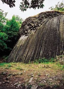
- Basic volcanism – represented by alcaline rock, is found in Central and Southern Slovakia and Hungary. The prevailing rock type is basalt with phenocrysts of olivine or nepheline (basalts in the area of Banská Štiavnica). There were lava flows in the vicinity of the Ostrá Lúka near Zvolen and Devičie near Krupina, lava flows and maars in the vicinity of Pinciná, Jelšovec, lava flows, necks, dikes, and maars in , and the youngest cinder cone, the , near the Nová Baňa.[9]
Metamorphism[]
The occurrence of metamorphosed crystalline rock in the Western Carpathians is known from the , , , and zones. Existing research has clearly demonstrated traces of the Hercynian and Alpine orogeny. Although some authors suggest the possible presence of the older Cadomian or Caledonian metamorphic cycles,[18] existence of the Precambrian metamorphic cycles was not confirmed because of the later metamorphic overprint.[19]
Caledonian metamorphism has not been clearly proved, but some signs are present in amphibolites of the Malé Karpaty Mts. (about 395 million years old) or the granite of Sihla type in the (about 370–380 million years old). More common is the Hercynian metamorphism, which is associated with regional and periplutonic metamorphism caused by intrusions of granitic rock, and low grade metamorphism of volcanosedimentary formations of several tectonic units to the greenschist facies. Signs of the Alpine metamorphism, which took place 75–107 million years ago, are well preserved in the Mesozoic formations of the , , and especially .[20] Special subduction related metamorphism to blueschist facies is known from the .[16]
Earthquakes[]
The Western Carpathians are from the neotectonic point of view part of the block. Main earthquakes in the ALCAPA were located in the subduction arc of the Hellenides and . Deep focus earthquakes are known only from the zone of Vrancea, where the subduction is still active. No deep focused earthquakes related to subduction were recorded in the Western Carpathians. A period of significant continental collision and shortening of the crust affected the area in the Miocene.[21] Later, primarily extensional and strike-slip movement in the Neogene generated new or reactivated older faults. There are five principal earthquake zones located in the area of the Western Carpathians: the Pezinok-Pernek zone, which is a continuation of the faults responsible for formation of the Vienna Basin, the Dobrá Voda zone with the most intensive and most shallow earthquakes around the , the Komáro zone of earthquakes, which joins the Rába-Hurbanovo-Darnó fault (also known as ), separating the Pelso unit from the Inner Carpathian crystalline basement, the Žilina zone of earthquakes, related to the ongoing collision and strike-slip movement in the Pieniny Klippen Belt, and the Central Slovakia zone, which is probably the result of tectonic activity of the .
Quaternary deposits[]
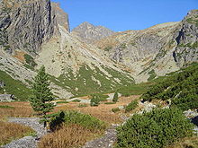
The Quaternary glaciations identified in the Western Carpathians are, from oldest to youngest: Donau, Günz, Mindel, Riss and Würm.[22] During these glaciations glaciers extender downhill from the High Tatras and nonglaciated uplands were subject to frost weathering and solifluction.[22] Deflation of soils is also evident in mountaineous locations.[22] Glaciofluvial cones formed in the forelands of the Western Carpathians in connection to the last glaciation.[22] Four systems of terminal and lateral moraines formed during the last glaciation and its inmediate aftermath have been recognised in the Slovak Carpathians.[22]
References[]
- ^ Jump up to: a b Mísař, Z., 1987: Regionální geologie světa. Academia, Praha, 708 pp.
- ^ "On-line geologická encyklopedie". geology.cz. 03-07-2008. Check date values in:
|date=(help) - ^ Jump up to: a b c d e Mišík, M., Chlupáč, I., Cicha, I., 1984: Historická a stratigrafická geológia. Slovenské pedagogické nakladateľstvo, Bratislava, 541 pp.
- ^ Jump up to: a b c d e Maheľ, M., 1986: Geologická stavba československých Karpát. Paleoalpínske jednotky 1. Veda, Bratislava, 503 pp.
- ^ Jump up to: a b c d Plašienka, D., Grecula, P., Putiš, M., Kováč, M. a Hovorka, D., 1997: Evolution and structure of the Western Carpathians: an overview. Archived 2011-08-26 at the Wayback Machine in Grecula, P., Hovorka, D., Putiš, M. (Eds.) Geological evolution of the Western Carpathians. Mineralia Slovaca - Monograph, Košice, pp. 1 – 24
- ^ Jump up to: a b c d e Plašienka, D., 1999: Tektochronológia a paleotektonický model jursko-kriedového vývoja centrálnych Západných Karpát. Veda, 125 pp.
- ^ Jump up to: a b c d e Biely, A. (Editor) 1996: Explanation to geological map of Slovakia. Dionýz Štúr Publishers, Bratislava, 76 pp.
- ^ Jump up to: a b c Hók, J., Kahan, Š., Aubrecht, R., 2001: Geológia Slovenska. Archived 2011-07-19 at the Wayback Machine Univerzita Komenského, Bratislava, 43 pp.
- ^ Jump up to: a b Vozár, J., Vojtko, R., Sliva, Ľ., (Editors) 2002: Guide to geological excursion. XVIIth Congress of Carpathian-Balkan Geological Association. Dionýz Štúr Publishers, Geological survey of Slovak republic, Bratislava, 163 pp.
- ^ Jump up to: a b c d e Kováč, M., Plašianka, D., 2002: Geological structure of the Alpine-Carpathian-Pannonian junction and neighbouring slopes of the Bohemian Massif. Comenius University, Bratislava, 88 pp.
- ^ Tomek, Č., 1993: Deep crustal structure beneath the central and inner West Carpathians. Tectonophysics, 226, pp. 417–431
- ^ Jump up to: a b c d Plašienka, D. 2006: Princípy regionalizácie geologickej stavby Malých Karpát a Považského Inovca. In: Kováč, M., Dubíková, K., Nové metódy a výsledky v geológii Západných Karpát. Zborník 2006, pp. 51 – 56
- ^ Jump up to: a b Vozárová, A., Vozár, J., 1988: Late paleozoic in Western Carpathians. Geologický ústav Dionýza Štúra, Bratislava, 303 pp.
- ^ Putiš, M., Hrdlička, M. a Uher, P., 2004: Litológia a granitoidný magmatizmus staršieho paleozoika Malých Karpát. Mineralia Slovaca, 36, pp. 183 – 194
- ^ Hovorka, D., 1990: Sopky. Veda, Bratislava, 147 pp.
- ^ Jump up to: a b Ivan, P., 2002: Relics of the Meliata ocean crust: Geodynamic implications of mineralogical, petrological and geochmical proxies. Geologica Carpathica, 53, 4, s. 245–256
- ^ Jump up to: a b Konečný, V., Lexa, J., Šimon, L., Dublan, L., 2001: Neogénny vulkanizmus stredného Slovenska. Mineralia Slovaca 33, pp. 159–178
- ^ Putiš, M., Segeev, S., Ondrejka, M., Larionov, A., Siman, P., Spišiak, J., Uher, P., Paderin, I., 2008: Cambrian-Ordovician metaigneous rocks associated with Cadomian fragments in the West-Carpathian basement dated by SHRIMP on zircons: a record from the Gondwana active margin setting. Geologica Carpathica, 59, 1, pp. 3–18
- ^ Krist, E., Krivý, M., 1985: Petrológia. Alfa, Bratislava, 464 pp.
- ^ Krist, E., Korikovskij, S.P., Putiš, M., Janák, M., Faryad, S.W, 1992: Geology and petrology of metamorphic rocks of the Western Carpathian crystalline complexes. Comenius University Press, Bratislava, 324 pp.
- ^ Marko, F., 2004: Fault controlled evolution of the ALCAPA region. Geolines, 17, pp. 68–69
- ^ Jump up to: a b c d e Vaškovský, Imrich; Vaškovská, Eugenia (1981). "The development of the natural landscape in Slovakia during the Quaternary". Biuletyn Peryglacjalny. 28: 249–258.
External links[]
| show Geology of Europe |
|---|

- Western Carpathians
- Geology of the Carpathians
- Geology of Austria
- Geology of Hungary
- Geology of Poland
- Geology of Slovakia
- Geology of the Czech Republic