Gerecse Mountains
| Gerecse | |
|---|---|
 | |
| Highest point | |
| Peak | Nagy-Gerecse |
| Elevation | 634 m (2,080 ft) |
| Dimensions | |
| Area | 850 km2 (330 sq mi) |
| Geography | |
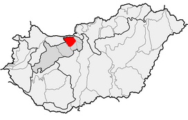 Location of Gerecse Mountains within physical subdivisions of Hungary
 | |
| Country | Hungary |
| County | Komárom-Esztergom County |
| Range coordinates | 47°38.6′N 18°24.3′E / 47.6433°N 18.4050°ECoordinates: 47°38.6′N 18°24.3′E / 47.6433°N 18.4050°E |
| Geology | |
| Orogeny | Transdanubian Mountains |
| Type of rock | chalk, limestone |

Gerecse is a mountain range in north-western Hungary,[clarification needed] that belongs to the Transdanubian Mountains
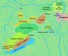
Geography[]
The range lies in the and connects Vértes Hills with Pilis Mountains in Komárom-Esztergom County, between the town of Tatabánya and the Danube River. Gerecse occupies an area of 850 km2 (20,300 ha). The highest point is Nagy-Gerecse at 634 m.[1] The main rock is limestone and chalk.
Biology[]
Deciduous oak forests cover the lower slopes, with submontane species of Quercus, Carpinus, Fagus, and at higher altitudes karst scrub. The area is 70% forest, 5% scrubland, 10% grassland, and 15% artificial landscapes.[1] Yearly sunshine duration is around 1,980 hours. The average annual temperature above the height of 350 meters is 9.5 C (in January -2,8 C). The average annual precipitation is 640 millimeters.
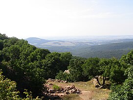
Gallery[]

Farkasvölgy (Wolf-valley)

Forest in the Gerecse

The monument of the Battle of , 1526

Gerecse near


See also[]
References[]
- ^ a b "Gerecse mountains". HungarianBirdwatching.com. 2004. Archived from the original on 2011-07-12. Retrieved 2010-11-22.
External links[]
- http://www.kektura.click.hu/keret.cgi?/OKT/szovegek/angol/tour_05.htm
- gerecse.lap.hu (in Hungarian)
- Gerecse (in Hungarian)
- Gerecse barlangjai (in Hungarian)
- Gerecsei Tájvédelmi Körzet (in Hungarian)

- Transdanubian Mountains