Velence Hills
| Velence Hills | |
|---|---|
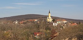 Nadap on the Velence Hills | |
| Highest point | |
| Peak | Meleg-hegy, 47°15′33″N 18°35′47″E / 47.259038°N 18.596496°ECoordinates: 47°15′33″N 18°35′47″E / 47.259038°N 18.596496°E |
| Elevation | 352 m (1,155 ft) |
| Geography | |
  | |
| Country | Hungary |
| County | Fejér County |
| Geology | |
| Orogeny | Transdanubian Mountains |

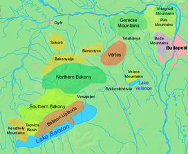
Velence Hills (Hungarian: Velencei-hegység) is a low mountain range in north-western Hungary, in the Central Transdanubian region. It lies to the north of Lake Velence, some 15 km to the east of city of Székesfehérvár. The Velence Hills are part of the Transdanubian Mountains. Village of Nadap lies in the central part of the hills and is the point of departure of excursions to the countryside.[1] The highest point, Meleg-hegy ("Hot hill") (352 m) lies above the village.[2]
Gallery[]


References[]
- ^ "Nadap". 1Hungary. Retrieved 11 August 2017.
- ^ "A település bemutatása". Official website of Nadap (in Hungarian). Retrieved 11 August 2017.
External links[]
 Media related to Velence Hills at Wikimedia Commons

| show Authority control |
|---|
This Fejér location article is a stub. You can help Wikipedia by . |
Categories:
- Transdanubian Mountains
- Fejér geography stubs